Haalderen
Haalderen is a village in the Netherlands, in the province of Gelderland. The village is located in the Betuwe region, and belongs to the municipality of Lingewaard.[1][2] Haalderen is situated along the rivers Waal and Linge.[3] It has a population of 2,061 (1 January 2020).[1]
Haalderen | |
|---|---|
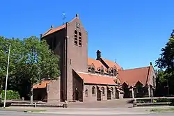 Church of Haalderen | |
 Haalderen | |
| Coordinates: 51°53′12″N 5°55′48″E | |
| Country | Netherlands |
| Province | Gelderland |
| Municipality | Lingewaard |
| Area | |
| • Total | 2.55 km2 (0.98 sq mi) |
| Elevation | 9 m (30 ft) |
| Population (2020) | |
| • Total | 2,061 |
| • Density | 810/km2 (2,100/sq mi) |
| Demonym(s) | Haaldernaar |
Physical geography
The territory of Haalderen is mainly located on river deposits. In the southwest of Haalderen there are river forelands of the Waal. Due to several levee breaches in the past, tree kolks (named Grote Kolk, Kleine Kolk and Groene Kolk) are still clearly visible in the current landscape of Haalderen. There is also a kolk lake in the border area of Haalderen and Bemmel (named Ronduit). Typical herbs that grow along the kolks of Haalderen are Inula britannica and Limosella aquatica.
Education
The village has one primary school: De Wieling. The school has about 250 pupils.
Notable residents
Notable people from Haalderen include:
- Joop Puntman (1934–2013), a Dutch ceramist and sculptor.[4]
Photo gallery
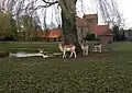 Deer Park Haalderen
_oorlogsmonument.JPG.webp) The war memorial
The war memorial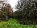 Haalders Bos
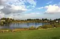 Kleine Kolk (kolk)
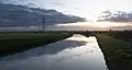 The Linge river
References
- Gemeente Lingewaard Feiten en cijfers (2020)
- City Population Haalderen in Lingewaard, Gelderland
- Maplandia.com Haalderen Map: Satellite Images of Haalderen
- RKD Joop Puntman Biographical Data
| Wikimedia Commons has media related to Haalderen. |
