Hailuoto
Hailuoto (Finnish: [ˈhɑi̯ˌluo̞̯t̪o̞]; Swedish: Karlö) is an island and a municipality in Northern Ostrobothnia region, Finland. The population of Hailuoto is 958 (July 31, 2020),[2] which make it the smallest municipality in Northern Ostrobothnia and the former Oulu Province in terms of population. The municipality covers an area of 200.53 km2 (77.43 sq mi) (excluding sea areas) of which 1.70 km2 (0.66 sq mi) is inland water (January 1, 2018).[1] The population density is 4.78/km2 (12.4/sq mi). Of all the Finnish islands in Finland's sea areas, Hailuoto is the third largest after Fasta Åland and Kimitoön.[7]
Hailuoto
Karlö | |
|---|---|
Municipality | |
| Hailuodon kunta Karlö kommun | |
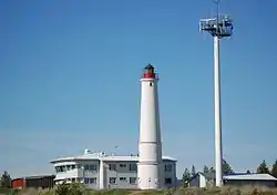 Pilot station and lighthouse in Marjaniemi | |
 Coat of arms | |
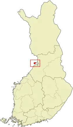 Location of Hailuoto in Finland | |
| Coordinates: 65°01′N 024°43′E | |
| Country | |
| Region | Northern Ostrobothnia |
| Sub-region | Oulu sub-region |
| Government | |
| • Municipal manager | Ari Nurkkala |
| Area (2018-01-01)[1] | |
| • Total | 1,082.70 km2 (418.03 sq mi) |
| • Land | 200.53 km2 (77.43 sq mi) |
| • Water | 882.17 km2 (340.61 sq mi) |
| Area rank | 261st largest in Finland |
| Population (2020-07-31)[2] | |
| • Total | 958 |
| • Rank | 298th largest in Finland |
| • Density | 4.78/km2 (12.4/sq mi) |
| Population by native language | |
| • Finnish | 99.1% (official) |
| • Swedish | 0.1% |
| • Others | 0.8% |
| Population by age | |
| • 0 to 14 | 13.9% |
| • 15 to 64 | 61.5% |
| • 65 or older | 24.6% |
| Time zone | UTC+02:00 (EET) |
| • Summer (DST) | UTC+03:00 (EEST) |
| Municipal tax rate[5] | 19.25% |
| Website | www.hailuoto.fi |
| Official name | Bird Wetlands of Hailuoto Island |
| Designated | 2 February 2004 |
| Reference no. | 1505[6] |
Hailuoto is located on an island of the same name opposite the city of Oulu in the Gulf of Bothnia. The distance between Oulu and Hailuoto is 53 kilometres (33 mi), and the sea area between them is called Luodonselkä (literally "the back of islet").[8] A ferry operates regularly between Hailuoto and Oulunsalo. In winter an official ice road connects the island to the mainland. Hailuoto also has a small airfield, Hailuoto Airfield, about 6 kilometres (4 mi) south of central village.[9]
Land in the region is constantly rising due to post-glacial rebound. It is estimated that the first parts of Hailuoto appeared from the Baltic Sea about 1700 years ago. The current island of Hailuoto was formed from many smaller islands. Two large sections, Santonen and Hanhinen merged into the main island (Luoto) only about two centuries ago. The island is continuously expanding and eventually it will join with the continent. Kirkkosalmi, a wetland region between Hanhinen and Luoto is renowned for being an important bird refuge where rare bird species are observed.
History
The permanent settlement of Hailuoto apparently began in the 12th century. Residents came from many directions, especially from Karelia. The Swedes, who competed for its fishing waters, gave the island the name Karelö (which was transformed into Karlö), which means freely translated "Karelian Island". The first permanent residents of Hailuoto were mostly from Western Finland, but some also came from Eastern Finland. In 1548 there were 43 houses on the island, and by 1570 the number of houses had grown to 60. Queen Christina of Sweden donated the entire island of Hailuoto in 1652 to Colonel Berndt Taube, from whose heirs it was returned to the crown in 1675.[10]
Hailuoto first belonged to the high parish of Saloinen (nowadays part of Raahe), from which it separated into an independent parish in 1587. The church, built in 1610–1620, was for a long time the oldest wooden church in use in Finland until it burned down in 1968.[11] The current church was completed in 1972.[12]
During the Great Famine of 1695–1697, 88 inhabitants of Hailuoto died.[10] During the Great Northern War (1713–1721), 200 Cossacks of the Tsardom of Russia killed about 800 people in Hailuoto with an ax on September 29, 1714. Many of the victims had sought protection on the island, as Hailuoto had a population of less than 300 at that time. The bloodshed done overnight was the greatest of the Great Northern War.[13] According to tradition, the bells of Hailuoto Church were drowned in Lake Kirkonjärvi during the Great Northern War, where they were never found again.[10]
Villages
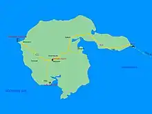
Järventakusta, Hailuoto, Koivukylä, Marjaniemi, Ojakylä, Pöllä, Ulkokarvo and Vaski.
Services
In the center village of Hailuoto there is a comprehensive school,[14] two grocery stores (K-Market and Sale), a bank (Osuuspankki), a barber shop and a filling station (SEO).[15]
The Arctic Light House Hotel for tourists is located right next to the Marjaniemi Lighthouse.[16]
Religion
According to the 2018 regional division, the only parishes in the municipality are the Hailuoto Parish of the Finnish Evangelical Lutheran Church[17] and the Oulu Orthodox Parish of the Finnish Orthodox Church.[18] Of the revival movements within the church, Conservative Laestadianism operates in the locality, which has the Hailuoto Peace Association (Hailuodon Rauhanyhdistys).[19]
Culture
The entire island of Hailuoto is classified as one of Finland's nationally significant built cultural environments.[20] The unique landscape and natural conditions have made Hailuoto, the largest island in the Bay of Bothnia, one of Finland's national landscapes.
Food
In the 1980s, fish potatoes made from European whitefish were named traditional food of the Hailuoto parish.[21]
Gallery
 Tourist Info Office
 Typical forest in Hailuoto
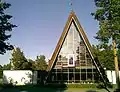 Hailuoto Church, built in 1972
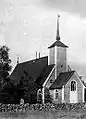 Old church, built in the 1610s, destroyed by fire in 1968
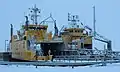 The ferries Meriluoto and Merisilta
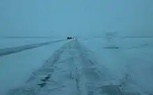 The ice road between the island and the mainland
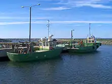 Fishing boats in Marjaniemi
See also
References
- "Area of Finnish Municipalities 1.1.2018" (PDF). National Land Survey of Finland. Retrieved 30 January 2018.
- "Suomen virallinen tilasto (SVT): Väestön ennakkotilasto [verkkojulkaisu]. Heinäkuu 2020" (in Finnish). Statistics Finland. Retrieved 13 September 2020.
- "Population according to language and the number of foreigners and land area km2 by area as of 31 December 2008". Statistics Finland's PX-Web databases. Statistics Finland. Retrieved 29 March 2009.
- "Population according to age and gender by area as of 31 December 2008". Statistics Finland's PX-Web databases. Statistics Finland. Retrieved 28 April 2009.
- "List of municipal and parish tax rates in 2011". Tax Administration of Finland. 29 November 2010. Retrieved 13 March 2011.
- "Bird Wetlands of Hailuoto Island". Ramsar Sites Information Service. Retrieved 25 April 2018.
- "Suomen merialueiden sata suurinta saarta" (in Finnish). Suomen Kuvalehti. June 15, 1987. p. 64. Cite magazine requires
|magazine=(help) - Facta 2001, WSOY, 1984 (in Finnish)
- "Hailuoto, Finland – EFHL". VFR Suomi / Finland. Vantaa: Finavia. 18 November 2010. Archived from the original on 21 April 2012. Retrieved 8 October 2020.
- Hannu Tarmio, Pentti Papunen & Kalevi Korpela: Suomenmaa 1: maantieteellis-yhteiskunnallinen tieto- ja hakuteos, p. 217–220. Porvoo-Helsinki: WSOY, 1967. (in Finnish)
- Kalevi Rikkinen (1986). Finlandia, Otavan iso maammekirja 8 (in Finnish). Helsinki: Otava. ISBN 951-1-09142-5.
- "Hailuodon seurakunta Hiski-tietokannassa" (in Finnish). Retrieved January 8, 2021.
- Kaitasuo, Pia (August 15, 2015). "Pietari Suuren synkkä tuhon kylvö". Kaleva (in Finnish). No. 221. Oulu: Kaleva Oy. pp. 34–35. ISSN 0356-1356.
- Comprehensive school – Hailuoto Website
- Stores and other services – Hsiluoto Website
- Hotel accommodation – Hailuoto Website
- Yhteystiedot - Suomen evankelis-luterilainen kirkko (in Finnish)
- Oulun ortodoksinen seurakunta (in Finnish)
- Hailuodon Rauhanyhdistys (in Finnish)
- Hailuoto - Pohjois-Pohjanmaa (in Finnish). Finnish Heritage Agency. Retrieved 8 January 2021.
- Jaakko Kolmonen (1988). Kotomaamme ruoka-aitta: Suomen, Karjalan ja Petsamon pitäjäruoat (in Finnish). Helsinki: Patakolmonen. p. 168. ISBN 951-96047-3-1.
External links
 Media related to Hailuoto at Wikimedia Commons
- hailuototourism.fi
- Municipality of Hailuoto – Official site (in English)
 Hailuoto travel guide from Wikivoyage
- Ferry timetables (in Finnish)
- Bothnian Bay Research Station of the University of Oulu
- Live webcam from the ferry
| Municipalities |  | |
|---|---|---|
| Former |
| |
