Kalajoki
Kalajoki is a coastal town and municipality of Finland. It is located in the province of Oulu and is part of the Northern Ostrobothnia region.
Kalajoki | |
|---|---|
Town | |
| Kalajoen kaupunki Kalajoki stad | |
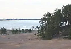 Sandy beaches of Kalajoki | |
 Coat of arms | |
 Location of Kalajoki in Finland | |
| Coordinates: 64°16′N 023°57′E | |
| Country | |
| Region | Northern Ostrobothnia |
| Sub-region | Ylivieska sub-region |
| Charter | 1865 |
| Town privileges | 2002 |
| Government | |
| • Town manager | Jukka Puoskari |
| Area (2018-01-01)[1] | |
| • Total | 2,391.30 km2 (923.29 sq mi) |
| • Land | 922.16 km2 (356.05 sq mi) |
| • Water | 1,469.15 km2 (567.24 sq mi) |
| Area rank | 84th largest in Finland |
| Population (2020-07-31)[2] | |
| • Total | 12,428 |
| • Rank | 82nd largest in Finland |
| • Density | 13.48/km2 (34.9/sq mi) |
| Population by native language | |
| • Finnish | 98.8% (official) |
| • Swedish | 0.2% |
| • Others | 1% |
| Population by age | |
| • 0 to 14 | 19.7% |
| • 15 to 64 | 63.2% |
| • 65 or older | 17.1% |
| Time zone | UTC+02:00 (EET) |
| • Summer (DST) | UTC+03:00 (EEST) |
| Municipal tax rate[5] | 19% |
| Website | www.kalajoki.fi |
The town has a population of 12,428 (31 July 2020)[2] and covers an area of 2,391.30 square kilometres (923.29 sq mi) of which 1,469.15 km2 (567.24 sq mi) is water.[1] The population density is 13.48 inhabitants per square kilometre (34.9/sq mi).
The municipality is unilingually Finnish.
History
The first reference to Kalajoki can be found from the beginning of 16th century and it got the status of a parish in 1525, it was designated as a regional parish in 1545. This status ended with the abolishment of the parish form of organization in the early 1860s. Kalajoki was a significant market place and controlled the whole region's tar trading. By the end of 19th century the meaning of tar was diminishing as a good and the importance of Kalajoki was reduced thereafter.
The tar trade was a derivative of the forestry industry, and Kalajoki has long been the location of forestry activities. There are still sawmills in operation in the city today.
In addition to tar trading, Kalajoki has long been a farming community, producing a variety of agricultural products, including wheat and rye. There are many farms still operating in the city, and there is a weekly market during the spring and summer months where local farmers and merchants sell their products.
Government
There were many attempts to reorganize Kalajoki as a city, which would confer additional authorities on the municipality. The first attempt was in 1865, and there were several subsequent attempts throughout the 20th century. Kalajoki was finally reorganized as a city in 2002.
Just like any municipality in Finland, the city of Kalajoki is composed of several sub-units, called a kylä. The following compose the city of Kalajoki: Vasankari, Plassi, Mehtäkylä, Pohjankylä, Pitkäsenkylä, Etelänkylä, Kääntä, Tynkä, Rahja, Kurikkala, Kärkinen, Typpö, Rautio.
Every four years, the voters of Kalajoki elect a city council of 35 members which meets monthly. The Council then elects a governing council of nine members that meets more regularly to transact the business of the city. As of the most recent municipal election in 2004, 19 members of the city council are from the Centre Party, 6 are from the local Pro Kalajoki Party, 4 are from the centre-right National Coalition Party, 3 are from the Left Alliance, 2 are from the centre-left Social Democratic Party, and one member is from the Christian Democrats Party.
The next municipal elections will be held throughout Finland in 2012.
The municipality of Rautio was consolidated with Kalajoki in 1973. The neighboring municipality of Himanka was consolidated with Kalajoki on January 1, 2010.[6]
Tourism
Kalajoki is a well known tourist attraction place in Finland due to long sandy beaches (sea) and related activities.
International relations
People born in Kalajoki
- Kalle Myllylä (1844 – 1923)
- Tuomas Pohjanpalo (1861 – 1933)
- Leonard Typpö (1868 – 1922; born in Rautio)
- Sakari Ainali (1874 – 1938; born in Himanka)
- Vilho Kivioja (1896 – 1977)
- Elias Simojoki (1899 – 1940; born in Rautio)
- Kauko Tuupainen (1940 – )
- Antti Haapakoski (1971 – )
- Rainer Nygård (1972 – )
- Jussi Jokinen (1983 – )
- Juho Jokinen (1986 – )
- Jaakko Rahja (1872 – 1926)
References
- "Area of Finnish Municipalities 1.1.2018" (PDF). National Land Survey of Finland. Retrieved 30 January 2018.
- "Suomen virallinen tilasto (SVT): Väestön ennakkotilasto [verkkojulkaisu]. Heinäkuu 2020" (in Finnish). Statistics Finland. Retrieved 13 September 2020.
- "Population according to language and the number of foreigners and land area km2 by area as of 31 December 2008". Statistics Finland's PX-Web databases. Statistics Finland. Retrieved 29 March 2009.
- "Population according to age and gender by area as of 31 December 2008". Statistics Finland's PX-Web databases. Statistics Finland. Retrieved 28 April 2009.
- "List of municipal and parish tax rates in 2011". Tax Administration of Finland. 29 November 2010. Retrieved 13 March 2011.
- Uusitalo, Heikki (29 April 2008). "Kalajoki ja Himanka virallistivat liittonsa". Kaleva.plus (in Finnish). Kaleva Kustannus Oy. STT. Retrieved 13 March 2009.
External links
| Wikimedia Commons has media related to Kalajoki. |
 Kalajoki travel guide from Wikivoyage
- Town of Kalajoki – Official website
- Kalajoki Tourism Information
| Municipalities |  | |
|---|---|---|
| Former |
| |
| Authority control |
|---|