Halsema Highway
Halsema Highway (also known as the Benguet–Mountain Province Road, Baguio–Bontoc Road or Mountain Trail[1]) is a national secondary highway in the Philippines. Situated within the Cordillera Central range in northern Luzon, it stretches from the city limit[2] of Baguio to the municipality of Bontoc.[3] Its highest point is at 7,400 feet (2,300 m) above sea level in the municipality of Atok.[4] It was officially recognized as the highest altitude highway in the Philippines[5] until 2019 when the 2,428.66 m (7,968.0 ft) high point Kiangan–Tinoc–Buguias Road in Tinoc, Ifugao was recognized as the new holder of the distinction.[6]
.svg.png.webp) | |
|---|---|
| Benguet–Mountain Province Road Baguio–Bontoc Road Mountain Trail | |
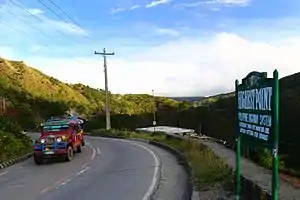 Highest point marker in Atok, Benguet | |
| Route information | |
| Length | 150.0 km (93.2 mi) |
| Component highways | |
| Major junctions | |
| North end | |
| |
| South end | Bokawkan Road in Baguio |
| Location | |
| Major cities | Baguio |
| Towns | |
| Highway system | |
| |
The 150-kilometre (93.2 mi)[5] highway covers 95 kilometres (59 mi)[7] of Benguet province and traverses eight of its municipalities (La Trinidad, Tublay, Atok, Bokod, Kabayan, Buguias, Bakun, and Mankayan). It also covers four Mountain Province towns (Bauko, Sabangan, Bontoc, and Sagada).[8] The road splits into two upon reaching the village of Dantay, in Bontoc. One road leads to downtown Bontoc,[4] while the other leads to the town of Sagada, 29 kilometres (18.0 mi) farther from the junction.
The entire highway forms a component of the National Route 204 (N204) of the Philippine highway network.
History
The highway was named after an American engineer, named Eusebius Julius Halsema,[1][9] who served as the mayor of Baguio City from 1920–1937. Under Halsema's term, its construction commenced in 1922 with the help of locals and was completed in 1930 as a foot trail.
Halsema Highway has been a crucial part of Cordillera's history and transportation. It's the only existing link between Baguio and Cordillera's most remote areas. It is the only route that vegetable farmers take to distribute vegetables in Baguio's markets.
Hazards
Parts of the highway are dangerous, especially during the rainy season, when landslides are common and asphalted portions become slippery.[5][9]
In March 2013, List25 included the highway at #9 in its 25 Most Dangerous Roads in the World.[5][10]
It was shown in Discovery World's show, Hot Roads - World's Most Dangerous Roads.
See also
References
- Halsema, James. "History and Biography of Euseibus Julius Halsema". Halsema.org. Retrieved 29 September 2014.
- Aure Galacgac, Aure (6 February 2014). "Halsema Highway to be made 'tourist friendly'". Sun.Star Baguio. Retrieved 29 September 2014.
- Sy, Marvin (9 June 2010). "NEDA: Vegetable prices to rise during rainy season". The Philippine Star. Retrieved 30 September 2014.
- Caluza, Desiree (26 May 2014). "Mountain Trail leads to culture, nature hubs". Philippine Daily Inquirer. Retrieved 30 September 2014.
- "Halsema Highway". Dangerous Roads. Retrieved 29 September 2014.
- Cimatu, Frank (20 March 2019). "Halsema Highroad Point dethroned as highest point in PH Highway System". Rappler. Retrieved 20 March 2019.
- "Province of Benguet". Department of Interior and Local Government (Philippines) - Cordillera Administrative Region. DILG-CAR. 7 March 2013. Archived from the original on 6 October 2014. Retrieved 30 September 2014.
- "Halsema Hway". Mapcentral. Retrieved 29 September 2014.
- Glover, Morgan (27 July 2014). "Halsema Highway: Most Dangerous Driving Roads". Elephant Car Hire. Retrieved 29 September 2014.
- "25 Most Dangerous Roads in the World". List25. 11 March 2013. Retrieved 29 September 2014.
| National roads |
| |||||||
|---|---|---|---|---|---|---|---|---|
| Other major roads | ||||||||