Naguilian Road
President Elpidio Quirino Highway (often shortened as Quirino Highway, formerly known and still referred to as Naguilian Road and also known as the Baguio–Bauang Road) is a Philippine major highway in northern Luzon that runs from the city of Baguio in the province of Benguet to the municipality of Bauang in the province of La Union.
.svg.png.webp) | ||||
|---|---|---|---|---|
| Naguilian Road Baguio–Bauang Road | ||||
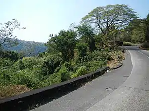 The highway in Burgos, La Union | ||||
| Route information | ||||
| Length | 46.0 km (28.6 mi) | |||
| Component highways | ||||
| Major junctions | ||||
| East end | ||||
| ||||
| West end | ||||
| Location | ||||
| Provinces | Benguet, La Union | |||
| Major cities | Baguio | |||
| Towns | Bauang, Burgos, Naguilian, Sablan, Tuba | |||
| Highway system | ||||
| ||||
The 46-kilometre (29 mi)[1] highway traverses the Benguet municipalities of Tuba and Sablan, and the La Union towns of Burgos, Naguilian and Bauang.[1][2]
The highway serves as a major access route to Baguio.[3] It is primarily used by motorists coming from the port city of San Fernando as well as the northern provinces of the Ilocos Region to get to the city.[1]
Although Quirino Highway is the official name of the road, most people are more used to calling it by its former name Naguilian Road.[4] It is also a component of National Route 54 (N54) of the Philippine highway network, where Kennon Road also belongs.
History
Naguilian Road, as it was once known, was the first and only road connecting the city to the lowlands, until Kennon Road was built in 1901.[5] The highway was renamed into "President Elpidio Quirino Highway", in honor of former Philippine President Elpidio Quirino.[6][7]
Intersections
| Province | Location | Destination[2] | Notes |
|---|---|---|---|
| Benguet | Baguio | Abanao Road | Eastern terminus |
| Shuntug Road | Eastern terminus | ||
| Kayang Street | |||
| Camp Henry T. Allen | |||
| Yandoc Road | |||
| Bokawkan Road | |||
| S. Gaerlan Street | |||
| Ferguson Road | |||
| Escoda Street | |||
| Hamada Street | |||
| Quezon Hill Road 2 | |||
| Dominican Hill Road | |||
| San Roque Road | |||
| S. De Deyra Street | |||
| Asin–Nangalisan–San Pascual Road | |||
| Tuba | Pico-Lamtang Road | ||
| La Union | Naguilian | Cayetano Street | |
| Aglipay Street | |||
| E. Rimando Street | |||
| P. Burgos Street | |||
| Madayag Street | |||
| Bauang | A. Luna Road | ||
| Nera Road | |||
| Western terminus |
See also
 Roads portal
References
- "Baguio's Three Major Access Roads". City of Pines. Archived from the original on 25 September 2014. Retrieved 29 September 2014.
- "Naguilian Rd". Mapcentral. Retrieved 29 September 2014.
- "Baguio Info". City Travel Hotel. Retrieved 29 September 2014.
- "How to Get to Baguio City". GoBaguio!. Retrieved 29 September 2014.
- "Baguio City Centennial Celebration". AMoores (WordPress). 30 August 2009. Retrieved 29 September 2014.
- "14-km circumferential road to spur business in Baguio City". Philippine Times of Southern Nevada. 7 May 2014. Retrieved 29 September 2014.
- "Seminary History". Casiciaco Recoletos. Archived from the original on 6 October 2014. Retrieved 29 September 2014.
| National roads |
| |||||||
|---|---|---|---|---|---|---|---|---|
| Other major roads | ||||||||