Hamadia
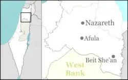
Hamadia (Hebrew: חֲמַדְיָה) is a kibbutz in the Beit She'an Valley, just north of Beit She'an in northern Israel. It belongs to the Valley of Springs Regional Council. In 2019 it had a population of 381.[1]
Hamadia
חֲמַדְיָה | |
|---|---|
 | |
 Hamadia  Hamadia | |
| Coordinates: 32°31′12.72″N 35°31′11.27″E | |
| Country | |
| District | Northern |
| Council | Valley of Springs |
| Affiliation | Kibbutz Movement |
| Founded | 1939 1942 (refoundation) |
| Population (2019)[1] | 381 |
Name
The kibbutz took its name from al-Hamidiyya, an abandoned Arab village north of the kibbutz named for the sultan of Ottoman Empire, Abdul Hamid II.
History
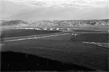
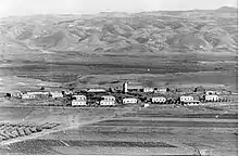
The kibbutz was founded in 1939 as part of the Tower and stockade movement. It was re-established in 1942 by the "Hermonim" pioneers, a garin of native-born Israelis who were part of a youth group.
Archaeology: Hamadiya Neolithic site
The Neolithic site at Kibbutz Hamadiya, known from archaeological literature as Hamadiya, is situated on a terrace of ancient Lake Beisan, 200 metres below sea level,[2] 10 km (6.2 mi) south of the prehistorical site of Munhata.[3] Hamadiya is suggested to date between ca. 5800 and 5400 BCE.[3] Detailed reports have yet to be published.[4]
Hamadiya is a single-layer archaeological site of about 100 m2 (0.010 ha), first reported and excavated by Nehemia Zori in 1958, then again by Jacob Kaplan in 1964.[5] Ovens, pits and fireplaces were found with Yarmukian pottery and an assemblage of many axes, picks, scrapers, "saw" elements and sickles. Large saw elements indicate possible earlier Neolithic occupation which was suggested to date at least to the early Chalcolithic (MOM period 7). A flint sickle workshop was located close to the site with over 300 sickle blades found.[3]

References
- "Population in the Localities 2019" (XLS). Israel Central Bureau of Statistics. Retrieved 16 August 2020.
- Michael Avi-Yonah (1978). Encyclopedia of archaeological excavations in the Holy Land, p. 468. 2. Prentice-Hall. ISBN 978-0-13-275123-0. Retrieved 3 May 2011.
- Francis Hours (1994). Atlas des sites du Proche Orient (14000-5700 BP). Maison de l'Orient méditerranéen. ISBN 978-2-903264-53-6. Retrieved 3 May 2011.
- Garfinkel, Y., The Yarmukian Culture in Israel, Paléorient, Volume 19, 19-1, pp. 115-134, 1993
- British School of Archaeology in Jerusalem (2005). Levant. Retrieved 3 May 2011.