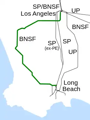
Harbor Subdivision
The Harbor Subdivision is a historic single-track main line of the BNSF Railway which stretches 26 miles (42 km) between rail yards near downtown Los Angeles and the ports of Los Angeles and Long Beach across southwestern Los Angeles County. It was the primary link between two of the world's busiest harbors and the transcontinental rail network. Mostly displaced with the April 15, 2002, opening of the more direct Alameda Corridor, the Harbor Sub takes a far more circuitous route from origin to destination, owing to its growth in segments over the decades. The subdivision was built in this fashion beginning in the early 1880s to serve the ports and the various businesses that developed along it.
| Harbor Subdivision | |||||||||||||||||||||||||||||||||||||||||||||||||||||||||||||||||||||||||||||||||||||||||||||||||||||||||||||||||||||||||||||||||||||||||||||||||||||||||||||||||||||||||||||||
|---|---|---|---|---|---|---|---|---|---|---|---|---|---|---|---|---|---|---|---|---|---|---|---|---|---|---|---|---|---|---|---|---|---|---|---|---|---|---|---|---|---|---|---|---|---|---|---|---|---|---|---|---|---|---|---|---|---|---|---|---|---|---|---|---|---|---|---|---|---|---|---|---|---|---|---|---|---|---|---|---|---|---|---|---|---|---|---|---|---|---|---|---|---|---|---|---|---|---|---|---|---|---|---|---|---|---|---|---|---|---|---|---|---|---|---|---|---|---|---|---|---|---|---|---|---|---|---|---|---|---|---|---|---|---|---|---|---|---|---|---|---|---|---|---|---|---|---|---|---|---|---|---|---|---|---|---|---|---|---|---|---|---|---|---|---|---|---|---|---|---|---|---|---|---|---|
| Overview | |||||||||||||||||||||||||||||||||||||||||||||||||||||||||||||||||||||||||||||||||||||||||||||||||||||||||||||||||||||||||||||||||||||||||||||||||||||||||||||||||||||||||||||||
| Status | operational | ||||||||||||||||||||||||||||||||||||||||||||||||||||||||||||||||||||||||||||||||||||||||||||||||||||||||||||||||||||||||||||||||||||||||||||||||||||||||||||||||||||||||||||||
| Locale | southwestern Los Angeles County, California, USA | ||||||||||||||||||||||||||||||||||||||||||||||||||||||||||||||||||||||||||||||||||||||||||||||||||||||||||||||||||||||||||||||||||||||||||||||||||||||||||||||||||||||||||||||
| Service | |||||||||||||||||||||||||||||||||||||||||||||||||||||||||||||||||||||||||||||||||||||||||||||||||||||||||||||||||||||||||||||||||||||||||||||||||||||||||||||||||||||||||||||||
| Operator(s) | BNSF Railway | ||||||||||||||||||||||||||||||||||||||||||||||||||||||||||||||||||||||||||||||||||||||||||||||||||||||||||||||||||||||||||||||||||||||||||||||||||||||||||||||||||||||||||||||
| Technical | |||||||||||||||||||||||||||||||||||||||||||||||||||||||||||||||||||||||||||||||||||||||||||||||||||||||||||||||||||||||||||||||||||||||||||||||||||||||||||||||||||||||||||||||
| Line length | 26 mi (42 km) | ||||||||||||||||||||||||||||||||||||||||||||||||||||||||||||||||||||||||||||||||||||||||||||||||||||||||||||||||||||||||||||||||||||||||||||||||||||||||||||||||||||||||||||||
| Track gauge | 4 ft 8 1⁄2 in (1,435 mm) standard gauge | ||||||||||||||||||||||||||||||||||||||||||||||||||||||||||||||||||||||||||||||||||||||||||||||||||||||||||||||||||||||||||||||||||||||||||||||||||||||||||||||||||||||||||||||
| |||||||||||||||||||||||||||||||||||||||||||||||||||||||||||||||||||||||||||||||||||||||||||||||||||||||||||||||||||||||||||||||||||||||||||||||||||||||||||||||||||||||||||||||
History
Construction
First built to serve Port Ballona and Santa Monica, located at what is now Playa del Rey, the construction of a larger, better port at Redondo Beach brought an extension to that city in 1888. The early 1900s would see that project eclipsed with the coming of the San Pedro Outer Breakwater and the Port of Los Angeles. By the early 1920s, owing to the development of the area's oil fields, the Harbor Sub was extended through Torrance, Wilmington and on to Long Beach. Development of Watson Yard in Wilmington completed the line. Other than sidings at "Lairport" (along the eastern edge of Los Angeles International Airport next to Aviation Boulevard at 120th Street), "Ironsides" in Torrance and the line's longest siding at the Alcoa, also in Torrance, the Harbor Sub is completely single-track without signals, compensated with track warrant control via a local dispatcher.
Present and potential future uses
The line is currently under control of the Los Angeles County Metropolitan Transportation Authority and is used by BNSF.
A study conducted by the MTA examined the feasibilities of extending the Green Line to Torrance via the Harbor Sub, the creation of a new light rail transit line[1] and even the possibility of a maglev high-speed rail system. [2]
Heavy construction began in June 2014 to convert the southern portion of the Harbor Subdivision to light rail use as part of the Crenshaw/LAX Line, part of the Los Angeles Metro Rail system.[3] When completed, it will run from Jefferson Park in the north and link with the Metro C Line at the south end with revenue service projected to begin by 2021.[4] The Harbor Subdivision overcrossing on Century Blvd. and Aviation Blvd. was demolished in late-July 2014 as part of the construction of the Crenshaw/LAX Line.[5]
References
- Brightwell, Eric (November 13, 2013). "Exploring the South Bay Metro Green Line Extension". Block by Block. KCET. Retrieved February 1, 2016.
- Metro Harbor Subdivision Transit Corridor Alternatives Analysis Report – Final (pdf). Los Angeles County Metropolitan Transportation Authority (Report). November 2009. Retrieved March 25, 2010.
- "Harbor Subdivision". LA Metro.
- "Crenshaw/LAX Transit Corridor (project website)". Metro (LACMTA). June 27, 2013. Retrieved September 11, 2013.
- Karlamangla, Soumya (June 23, 2014). "Officials say 57-hour 'Century Crunch' will close road to LAX in July". Los Angeles Times. Retrieved December 31, 2015.