Hardy Island
Hardy Island is an island of the Northern Gulf Islands archipelago located in the Sunshine Coast region of British Columbia.
| Hardy Island | |
|---|---|
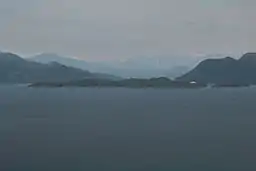 Hardy Island viewed from the west | |
 Location of Hardy Island in British Columbia | |
| Location | Sunshine Coast RD, British Columbia |
| Coordinates | 49°44′31″N 124°11′51″W[1] |
| Part of | Northern Gulf Islands |
| Area | 7.25 km2 (2.80 sq mi) |
Etymology
Hardy Island was named for Sir Thomas Hardy, 1st Baronet who was captain of HMS Victory at the Battle of Trafalgar when Nelson died in his arms.[2]:105
Geography
The island is surrounded by Jervis Inlet to the north and west, Blind Bay to the east, and Malaspina Strait to the south. The northwestern corner of the island forms the eastern part of the outlet of Jervis Inlet as it empties into Malaspina Strait. The northeastern corner of the island lies no more than 0.25 km (0.16 mi) away from Nelson Island.[1]
Blind Bay is an important anchorage for tugboats, tows and marine pleasure craft escaping the weather in Malaspina Strait.
The island is accessible via ferry or private watercraft.
Attractions
Hardy Island Marine Provincial Park is located near the southern tip of the island.
References
- "BC Geographical Names". apps.gov.bc.ca. Retrieved 2020-09-25.
- Akrigg, G.P.V.; Akrigg, Helen B. (1986), British Columbia Place Names (3rd, 1997 ed.), Vancouver: UBC Press, ISBN 0-7748-0636-2