Discovery Island (British Columbia)
Discovery Island is located off the eastern side of Vancouver Island and is viewable from Ten Mile Point, near Cadboro Bay, and Oak Bay. Discovery Island Marine Provincial Park occupies the southern portion of Discovery Island, 3 miles (4.8 km) east of Oak Bay. The northern portion of the island is part of Discovery Island Indian Reserve 3, under the control of the Songhees First Nation.
Discovery island was named in 1846 by surveyors in honour of HMS Discovery, the ship used by 18th-century British Explorer Captain George Vancouver to chart the coastline of British Columbia between 1792 and 1794 (see the Vancouver Expedition). The adjacent Chatham Islands were named after his escort ship, HMS Chatham.
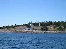
The Lighthouse at Sea Bird Point, the eastern end of Discovery Island, marks the junction of the Haro and Juan De Fuca Straits. These two straits form the border between Canada and the United States. The lighthouse was built in 1886 and manned for 110 years before being fully automated in 1996. The island has two homes for light keepers families, a helicopter pad, a diesel power generation station, a well, a water reservoir, a boathouse and dock. The coast guard used to keep a truck on the island. Sea Bird Point was named after an American paddle steamer which caught fire and was run aground in 1858 to save the lives of the crew.
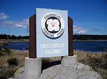
Designated as a park in 1972, the uninhabited and undeveloped 61-hectare Discovery Island Marine Provincial Park was once the home of Captain E.G. Beaumont, who purchased part of the island in 1918. He died in 1967 after living on Discovery Island with his wife for nearly half a century. Beaumont owned roughly 160 acres (half) of Discovery Island, and in his will gave his share of the island to the province of British Columbia (with the exception of 8.71 acres, which was transferred to Scouts Canada and later sold to private owners).[1] Beaumont was an avid seaman and even in his 80s would regularly row his boat from Discovery Island to Ten Mile Point, where he would go for walks in the woods. Evidence of the Beaumonts' beautiful home and gardens overlooking Rudlin Bay can still be seen. The home was designed on a nautical motif by the noted architect Francis Rattenbury.
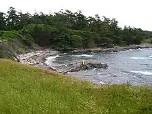
Discovery Island Marine Provincial Park is open year round. There is a camping fee and services provided from May 1 - September 30. During the off-season, there is no fee and no services. There are gravel beaches and a few walking and hiking trails along the shores and through fir and arbutus woodlands. The trail system runs from the lighthouse on Sea Bird Point to Commodore Point and across to the western shore of the park. Hikers can ascend the 38-metre (125 foot) Pandora Hill for improved views of the area and spectacular sweeping views of the Olympic Mountains.
In May 2012 a lone wolf took up residence on Discovery Island. The park was closed and attempts to trap the wolf were made, but these were unsuccessful, and it was decided to reopen the park. The wolf has so far proven safe to humans, and as of March 2019 still inhabited the island.[2] The lone wolf, Takaya, was relocated to an area near Port Renfrew by conservation officers in January 2020. After relocation, Takaya was shot and killed by a hunter in March 2020.[3]
Other flora and fauna on the island include sea lions, seals, mink, mussels, clams, rock crab, morel mushrooms, and blackberries.
Climate
Discovery Island has a Mediterranean climate (Csb) with some of the mildest winters in Canada, if not the mildest, even by British Columbia standards, having a yearly mean of 11.5 °C (52.7 °F), warmer than Victoria's University weather station which has a yearly mean of 11.2 °C (52.2 °F). Snowfall is extremely rare with over three-fourths of years not experiencing a single snowfall, which is a sharp contrast to the rest of the country.
| Climate data for Discovery Island, British Columbia | |||||||||||||
|---|---|---|---|---|---|---|---|---|---|---|---|---|---|
| Month | Jan | Feb | Mar | Apr | May | Jun | Jul | Aug | Sep | Oct | Nov | Dec | Year |
| Record high °C (°F) | 14.5 (58.1) |
14.5 (58.1) |
17.5 (63.5) |
24.5 (76.1) |
27 (81) |
29.5 (85.1) |
32 (90) |
33.5 (92.3) |
32.2 (90.0) |
21.9 (71.4) |
16.5 (61.7) |
14.2 (57.6) |
33.5 (92.3) |
| Average high °C (°F) | 8.9 (48.0) |
9.5 (49.1) |
10.9 (51.6) |
13.4 (56.1) |
15.4 (59.7) |
18 (64) |
19.6 (67.3) |
19.5 (67.1) |
18.4 (65.1) |
14 (57) |
10.9 (51.6) |
9.1 (48.4) |
14 (57) |
| Average low °C (°F) | 5.8 (42.4) |
6.1 (43.0) |
6.6 (43.9) |
8.2 (46.8) |
9.9 (49.8) |
11.6 (52.9) |
12.6 (54.7) |
12.7 (54.9) |
11.9 (53.4) |
10.0 (50.0) |
7.8 (46.0) |
6.0 (42.8) |
9.1 (48.4) |
| Record low °C (°F) | −6.5 (20.3) |
−5.2 (22.6) |
−2.5 (27.5) |
2.3 (36.1) |
4.5 (40.1) |
0 (32) |
9.1 (48.4) |
5.5 (41.9) |
7.5 (45.5) |
2.8 (37.0) |
−5.8 (21.6) |
−6.4 (20.5) |
−6.5 (20.3) |
| Source: https://web.archive.org/web/20140424025317/http://climate.weather.gc.ca/climateData/monthlydata_e.html?timeframe=3&Prov=BC&StationID=27226&mlyRange=1998-05-01%7C2005-08-01&cmdB2=Go&cmdB1=Go&Year=2003&cmdB2=Go# | |||||||||||||
References
- Beaumont, Ernest Godfrey. Last will. Dated September 3 1964.
- Crescenzi, Nicole (2019-03-20). "Discovery Island wolf continues to thrive". Oak Bay News. Retrieved 2020-08-03.
- Kelly, Alanna (2020-03-25). "Takaya, the lone wolf of Discovery Island, has been shot and killed". Vancouver Island. Retrieved 2020-04-02.