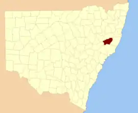
Hawes County

Hawes County is one of the 141 Cadastral divisions of New South Wales. It is bounded on the south by the Manning River.

Hawes
New South Wales
Location in New South Wales
Lands administrative divisions around Hawes:
Parry Vernon Dudley
Brisbane Hawes Macquarie
Durham Gloucester Gloucester

Hawes County was named in honour of Sir Benjamin Hawes (1797–1862).[1]

Parishes within this county

A full list of parishes found within this county; their current LGA and mapping coordinates to the approximate centre of each location is as follows:

ParishLGACoordinates
BarnardMid-Coast Council31°40′54″S 151°44′04″E
BarryUpper Hunter Shire31°37′54″S 151°18′04″E
BrockWalcha Shire31°22′54″S 151°49′04″E
CampbellUpper Hunter Shire31°39′54″S 151°28′04″E
CobbMid-Coast Council31°43′54″S 151°48′04″E
CoolcumbaWalcha Shire31°25′54″S 151°29′04″E
CooplacurripaMid-Coast Council31°36′54″S 151°51′04″E
CouatwongWalcha Shire31°28′54″S 151°45′04″E
CurracabundiMid-Coast Council31°37′24″S 151°38′04″E
CurricabarkUpper Hunter Shire31°42′54″S 151°27′04″E
DewittMid-Coast Council31°46′54″S 151°43′04″E
GiroMid-Coast Council31°38′54″S 151°48′04″E
HallTamworth Regional Council31°36′54″S 151°32′04″E
HastingsPort Macquarie-Hastings Council31°24′54″S 152°14′04″E
HawesWalcha Shire31°25′54″S 151°56′04″E
LowryWalcha Shire31°29′29″S 151°51′31″E
MackayMid-Coast Council31°45′54″S 151°55′04″E
MernotMid-Coast Council31°40′54″S 151°34′04″E
MukkiWalcha Shire31°22′54″S 151°37′04″E
MummelMid-Coast Council31°35′54″S 151°52′04″E
MurrayWalcha Shire31°25′54″S 152°02′04″E
MyallWalcha Shire31°32′54″S 151°33′04″E
MyraMid-Coast Council31°45′54″S 151°38′04″E
NaylorHastings31°20′54″S 152°10′04″E
NowendocWalcha Shire31°32′54″S 151°38′04″E
ParkesWalcha Shire31°29′54″S 151°25′04″E
RowleyWalcha Shire31°29′54″S 152°02′04″E
RushbrookWalcha Shire31°20′54″S 152°04′04″E
SchofieldUpper Hunter Shire31°38′54″S 151°21′04″E
TobinHastings31°23′54″S 152°09′04″E
TogaloWalcha Shire31°34′54″S 151°43′04″E
TomallaUpper Hunter Shire31°47′54″S 151°29′04″E
UriamukkiWalcha Shire31°22′54″S 151°44′04″E
VantTamworth Regional Council31°31′54″S 151°17′04″E
WardMid-Coast Council31°32′54″S 151°47′04″E
WerrikimbeHastings31°14′54″S 152°11′04″E
WhiteWalcha Shire31°20′54″S 152°00′04″E
WokoMid-Coast Council31°47′54″S 151°52′04″E
YeerawunTamworth Regional Council31°34′54″S 151°14′04″E

References

  1. "Hawes County". Geographical Names Register (GNR) of NSW. Geographical Names Board of New South Wales.
This article is issued from Wikipedia. The text is licensed under Creative Commons - Attribution - Sharealike. Additional terms may apply for the media files.