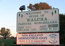
Walcha Shire
Walcha Shire is a local government area located in the New England region of New South Wales, Australia. The Shire is situated adjacent to the junction of the Oxley Highway and Thunderbolts Way and is 20 kilometres (12 mi) east of the Main North railway line passing through Walcha Road. The shire was formed on 1 June 1955 through the amalgamation of Apsley Shire and the Municipality of Walcha.[4]
| Walcha Shire New South Wales | |||||||||||||||
|---|---|---|---|---|---|---|---|---|---|---|---|---|---|---|---|
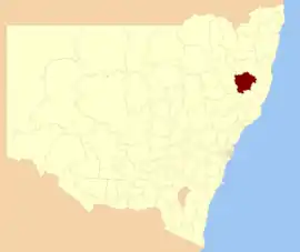 Location in New South Wales | |||||||||||||||
| Coordinates | 30°59′S 151°36′E | ||||||||||||||
| Population |
| ||||||||||||||
| • Density | 0.49338/km2 (1.27784/sq mi) | ||||||||||||||
| Established | 1 June 1955 | ||||||||||||||
| Area | 6,267 km2 (2,419.7 sq mi) | ||||||||||||||
| Mayor | Janelle Archdale (Unaligned) | ||||||||||||||
| Council seat | Walcha[3] | ||||||||||||||
| Region | New England | ||||||||||||||
| State electorate(s) | Tamworth | ||||||||||||||
| Federal Division(s) | New England | ||||||||||||||
| Website | Walcha Shire | ||||||||||||||
| |||||||||||||||
The Mayor of Walcha Shire Council is Cr. James Fermanis an unaligned politician.
Main towns and villages
The towns and villages of Walcha Council include Walcha, Walcha Road, Niangala, Nowendoc and Woolbrook. Settlements include: Brackendale, Yarrowitch, Tia and Bendemeer.
Demographics
| Selected historical census data for Hay Shire local government area | ||||||
|---|---|---|---|---|---|---|
| Census year | 2001[5] | 2006[6] | 2011[7] | 2016[1] | ||
| Population | Estimated residents on census night | 3,102 | ||||
| LGA rank in terms of size within New South Wales | 120th | |||||
| % of New South Wales population | 0.05% | |||||
| % of Australian population | 0.02% | |||||
| Cultural and language diversity | ||||||
| Ancestry, top responses | Australian | 36.5% | ||||
| English | 33.0% | |||||
| Scottish | 9.2% | |||||
| Irish | 9.1% | |||||
| German | 3.7% | |||||
| Language, top responses (other than English) | Maori (Cook Islands) | 0.3% | ||||
| Swedish | n/c | |||||
| Mandarin | n/c | |||||
| Tongan | n/c | |||||
| German | n/c | |||||
| Religious affiliation | ||||||
| Religious affiliation, top responses | Anglican | 44.8% | ||||
| Catholic | 21.2% | |||||
| No Religion, so described | 6.7% | |||||
| Not stated | n/c | |||||
| Presbyterian and Reformed | 12.7% | |||||
| Median weekly incomes | ||||||
| Personal income | Median weekly personal income | A$377 | A$459 | A$577 | ||
| % of Australian median income | 80.9% | |||||
| Family income | Median weekly family income | A$920 | A$1,077 | A$1,329 | ||
| % of Australian median income | 78.6% | |||||
| Household income | Median weekly household income | A$686 | A$826 | A$1,054 | ||
| % of Australian median income | 66.8% | |||||
Incomes
According to the Australian Bureau of Statistics[8] during 2003-04, there:
- were 927 wage and salary earners (ranked 146th in New South Wales and 470th in Australia, less than 0.1% of both New South Wales's 2,558,415 and Australia's 7,831,856)
- was a total income of $27,787,248 (around $28 million) (ranked 147th in New South Wales and 478th in Australia, less than 0.1% of both New South Wales's $107 billion and Australia's $304 billion)
- was an estimated average income per wage and salary earner of $29,975 (ranked 153rd in New South Wales and 517th in Australia, 72% of New South Wales's $41,407 and 77% of Australia's $38,820)
- was an estimated median income per wage and salary earner of $27,590 (ranked 154th in New South Wales and 517th in Australia, 78% of New South Wales's $35,479 and 81% of Australia's $34,149).
Heritage listings
There are heritage listings in Walcha, Walcha Road, and in Woolbrook.
The heritage-listed sites in Walcha are:
- Ohio Homestead[9]
- South Street: St Andrew's Anglican Church[10]
- Thee Street: St Andrew's Anglican Rectory[11]
The heritage-listed sites in Walcha Road are:
- Main Northern railway: Walcha Road railway station[12]
The heritage-listed sites in Woolbrook are:
Council
Current composition and election method
Walcha Shire Council is composed of eight Councillors elected proportionally as four separate wards, each electing two Councillors. All Councillors are elected for a fixed four-year term of office. The Mayor is by the Councillors at the first meeting of the Council. The most recent election was held on 10 September 2016. The makeup of the Council is as follows:[14][15][16][17]
| Party | Councillors | |
|---|---|---|
| Unaligned | 8 | |
| Total | 8 | |
The current Council, elected in 2016, in order of election by ward, is:
| Ward | Councillor | Party | Notes | |
|---|---|---|---|---|
| Ward A[15] | Rachael Wellings | Unaligned | ||
| Peter Blomfield | Independent | |||
| Ward B[16] | Eric Noakes | Unaligned | Mayor[18] | |
| Clint Lyon | Unaligned | Deputy Mayor[18] | ||
| Ward C[17] | Jennifer Kealey | Unaligned | ||
| Scott Kermode | Unaligned | |||
| Ward D[14] | Bill Heazlett | Unaligned | ||
| Kevin Ferrier | Unaligned | |||
At the 2012 local government elections, a referendum to abolish the four wards and elect Councillors as one entire ward was defeated, with 56.1% voting against the resolution.[19]
History
The Shire of Apsley, its predecessor, was constituted by proclamation on 7 March 1906 and is located in the Vernon, Hawes, and Inglis counties, and comprises about 60 parishes. The area is 1,605,590 acres (6,497.6 km2). The Shire of Walcha was constituted by the union of the Municipality of Walcha and the Shire of Apsley on 1 June 1955.[20]
On 28 and 29 November 2008, torrential rain that caused severe flooding in the Apsley River and Macdonald River led to the area being declared a natural disaster area. Walcha Council estimated that it will cost approximately $1.7 million to repair damage caused to roads and infrastructure across the shire.[21]
Proposed amalgamation
A 2015 review of local government boundaries recommended that the Walcha Shire merge with adjoining councils. The government considered two proposals. The first proposed a merger of Walcha Shire with the Tamworth Regional Council to form a new council with an area of 16,146 square kilometres (6,234 sq mi) and support a population of approximately 64,000.[22] An alternative proposal, submitted by the Armidale Dumaresq Council on 1 March 2016, was for an amalgamation of the Armidale Dumaresq, Guyra, Uralla and Walcha councils.[23] On 12 May 2016, the merger proposal was struck down - leaving Walcha Council to stand alone as a solo entity.
References
- Australian Bureau of Statistics (27 June 2017). "Walcha (A)". 2016 Census QuickStats. Retrieved 8 December 2017.

- "3218.0 – Regional Population Growth, Australia, 2017-18". Australian Bureau of Statistics. 27 March 2019. Retrieved 27 March 2019. Estimated resident population (ERP) at 30 June 2018.
- "Walcha Council". Department of Local Government. Retrieved 3 December 2006.
- "Local Government Act 1919. Proclamation (49)". Government Gazette of the State of New South Wales. 13 May 1955. p. 1331. Retrieved 9 January 2020 – via National Library of Australia.
- Australian Bureau of Statistics (9 March 2006). "Walcha (A)". 2001 Census QuickStats. Retrieved 21 November 2020.
- Australian Bureau of Statistics (25 October 2007). "Walcha (A)". 2006 Census QuickStats. Retrieved 21 November 2020.
- Australian Bureau of Statistics (31 October 2012). "Walcha (A)". 2011 Census QuickStats. Retrieved 21 November 2020.
- "Regional Wage and Salary Earner Statistics, Australia (catalogue no.: 5673.055.003)". Australian Bureau of Statistics. Retrieved 11 March 2007.
- "Ohio Homestead". New South Wales State Heritage Register. Office of Environment and Heritage. H00463. Retrieved 18 May 2018.
- "St. Andrew's Anglican Church (former)". New South Wales State Heritage Register. Office of Environment and Heritage. H00469. Retrieved 18 May 2018.
- "St. Andrews Rectory (former)". New South Wales State Heritage Register. Office of Environment and Heritage. H00295. Retrieved 18 May 2018.
- "Walcha Road Railway Station and yard group". New South Wales State Heritage Register. Office of Environment and Heritage. H01281. Retrieved 18 May 2018.
- "Woolbrook rail bridge over McDonald River". New South Wales State Heritage Register. Office of Environment and Heritage. H01067. Retrieved 2 June 2018.
- "Walcha Council - D Ward: Summary of First Preference Votes for each Candidate". Local Government Elections 2016. Electoral Commission of New South Wales. 19 September 2016. Retrieved 2 November 2016.
- "Walcha Council - A Ward: Summary of First Preference Votes for each Candidate". Local Government Elections 2016. Electoral Commission of New South Wales. 19 September 2016. Retrieved 2 November 2016.
- "Walcha Council - B Ward: Summary of First Preference Votes for each Candidate". Local Government Elections 2016. Electoral Commission of New South Wales. 19 September 2016. Retrieved 2 November 2016.
- "Walcha Council - C Ward: Summary of First Preference Votes for each Candidate". Local Government Elections 2016. Electoral Commission of New South Wales. 19 September 2016. Retrieved 2 November 2016.
- "Walcha Shire mayor Eric Noakes elected to lead new council". Armidale Express. Australia. 28 September 2016. Retrieved 2 November 2016.
- "Walcha Council - Referendum". Local Government Elections 2012. Electoral Commission of New South Wales. 14 September 2012. Retrieved 12 October 2012.
- Walcha 100 years of Local Government. Walcha: Walcha Shire Council. 1989.
- "Flood clean up". Walcha News. 11 December 2008.
- "Merger proposal: Tamworth Regional Council, Walcha Council" (PDF). Government of New South Wales. January 2016. p. 7. Retrieved 7 March 2016.
- Armidale Dumaresq Council (1 March 2016). "Merger proposal: Armidale Dumaresq Council, Guyra Shire Council, Uralla Shire Council and Walcha Council" (PDF). Government of New South Wales. Retrieved 7 March 2016.