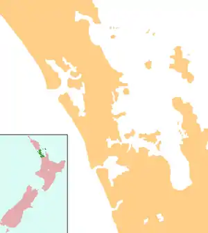
Helensville
Helensville is a town in the North Island of New Zealand. It is sited 40 kilometres northwest of Auckland, close to the southern extremity of the Kaipara Harbour. State Highway 16 passes through the town, connecting it to Waimauku 16 km to the south, and Kaukapakapa about 12 km to the north-east. Parakai is 2 km to the north-west.

Helensville | |
|---|---|
 Helensville | |
| Coordinates: 36°40′47″S 174°26′58″E | |
| Country | |
| Region | Auckland |
| Territorial authority | Auckland Council |
| Ward | Rodney |
| Population (June 2020)[1] | |
| • Total | 3,070 |
| Postcode(s) | 0800 |
The Kaipara River runs through the town and into the Kaipara Harbour to the north.[2][3]
Early history
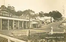
The area around Helensville was originally called Te Awaroa, meaning "The long path" or "The long river valley". The first European settlers in the district were Scottish timber millers named McLeod but who had actually come from Nova Scotia to New Zealand. John McLeod built a house which he named "Helen's Villa" in honour of his wife, and the name soon became that of the surrounding settlement.
Initial development of the town was around the kauri milling industry, but by the start of the 20th century dairying was becoming of increasing importance. It was also becoming somewhat of a tourist centre, owing to the presence of hot springs 3 km to the west of the town at Parakai.
A lot of the early history of Helensville is described in the book Men Came Voyaging written by Colleen Sheffield, who lost her life in a bus accident before the book was completed.
Demographics
| Year | Pop. | ±% p.a. |
|---|---|---|
| 2006 | 2,532 | — |
| 2013 | 2,643 | +0.61% |
| 2018 | 2,787 | +1.07% |
| Source: [4] | ||
Helensville had a population of 2,787 at the 2018 New Zealand census, an increase of 144 people (5.4%) since the 2013 census, and an increase of 255 people (10.1%) since the 2006 census. There were 993 households. There were 1,413 males and 1,377 females, giving a sex ratio of 1.03 males per female. The median age was 36.7 years, with 642 people (23.0%) aged under 15 years, 507 (18.2%) aged 15 to 29, 1,221 (43.8%) aged 30 to 64, and 417 (15.0%) aged 65 or older.
Ethnicities were 84.6% European/Pākehā, 20.3% Māori, 7.6% Pacific peoples, 4.2% Asian, and 1.3% other ethnicities (totals add to more than 100% since people could identify with multiple ethnicities).
The proportion of people born overseas was 17.8%, compared with 27.1% nationally.
Although some people objected to giving their religion, 56.3% had no religion, 30.2% were Christian, and 5.9% had other religions.
Of those at least 15 years old, 330 (15.4%) people had a bachelor or higher degree, and 435 (20.3%) people had no formal qualifications. The median income was $31,600. The employment status of those at least 15 was that 1,065 (49.7%) people were employed full-time, 327 (15.2%) were part-time, and 87 (4.1%) were unemployed.[4]
Rural surrounds
| Year | Pop. | ±% p.a. |
|---|---|---|
| 2006 | 1,209 | — |
| 2013 | 1,335 | +1.43% |
| 2018 | 1,524 | +2.68% |
| Source: [5] | ||
The rural area around Helensville, covering 57 square kilometres, had a population of 1,524 at the 2018 New Zealand census, an increase of 189 people (14.2%) since the 2013 census, and an increase of 315 people (26.1%) since the 2006 census. There were 498 households. There were 771 males and 753 females, giving a sex ratio of 1.02 males per female. The median age was 42.4 years, with 306 people (20.1%) aged under 15 years, 264 (17.3%) aged 15 to 29, 771 (50.6%) aged 30 to 64, and 183 (12.0%) aged 65 or older.
Ethnicities were 93.7% European/Pākehā, 11.6% Māori, 3.0% Pacific peoples, 2.8% Asian, and 1.4% other ethnicities (totals add to more than 100% since people could identify with multiple ethnicities).
The proportion of people born overseas was 21.7%, compared with 27.1% nationally.
Although some people objected to giving their religion, 61.6% had no religion, 28.3% were Christian, and 3.7% had other religions.
Of those at least 15 years old, 225 (18.5%) people had a bachelor or higher degree, and 195 (16.0%) people had no formal qualifications. The median income was $40,100. The employment status of those at least 15 was that 672 (55.2%) people were employed full-time, 180 (14.8%) were part-time, and 42 (3.4%) were unemployed.[5]
Governance
Helensville is part of the Local Government Rodney Ward of Auckland Council and is part of the Kumeu Subdivision of the Rodney Local Board.
Helensville is in the Helensville Electorate however proposed Boundary changes in late 2019 could change this.
The original local government was called Helensville Borough Council, which started in 1947 and merged into Rodney District Council in 1989, eventually being amalgamated into Auckland Council in November 2010.
Mayors during Helensville Borough Council
During the 42-year existence of Helensville Borough Council, it had eight mayors:[6]
| Name | Term | |
|---|---|---|
| 1 | Reg Screaton | 1947–1950 |
| 2 | Herbert Onslow Strong | 1950–1953 |
| 3 | Charles S. West | 1953–1956 |
| 4 | Lionel M. T. Wotton | 1956–1961 |
| 5 | Arthur B. West | 1961–1968 |
| 6 | G. C. Russell | 1968–1974 |
| 7 | George A. Smith | 1974–1986 |
| 8 | Eric J. Glavish | 1986–1989 |
Economy
Formerly a forestry or dairy centre, Helensville is increasingly becoming a dormitory suburb of Auckland with an increasing number of lifestyle blocks in the area. There is some economic benefit from the wine producing region around Kumeū, 20 km to the south. The principal tourist attraction is the hot springs at nearby Parakai.
Helensville has its own locally produced monthly newspaper, the Helensville News.[7]
The township is in the North West Country Inc business improvement district zone[8] which represents businesses from Kaukapakapa to Riverhead.
Education
Kaipara College is a secondary (years 9-13) school[9] with a roll of 885[10] as of March 2020. The school began as Helensville District High School in 1924, and changed its name to Kaipara College in 1959.[11]
Helensville Primary School is a full primary (years 1-8) school[12] with a roll of 442[10] as of March 2020. It was founded in 1877.[13]
Tau Te Arohanoa Akoranga is a satellite campus of the state-integrated Kingsway School, offering a Christian-based education.[14]
All these schools are coeducational.
Transport
Helensville railway station is on the North Auckland Line but the station has been closed since 2009.[15]
With the cessation of the passenger train service the only public transport between Helensville and central Auckland is by buses to and from Westgate in west Auckland then transfer to another bus route 110 to central Auckland. At rush hours an express bus operates to Downtown.
References
- "Population estimate tables - NZ.Stat". Statistics New Zealand. Retrieved 22 October 2020.
- Peter Dowling (editor) (2004). Reed New Zealand Atlas. Reed Books. map 11. ISBN 0-7900-0952-8.CS1 maint: extra text: authors list (link)
- Roger Smith, GeographX (2005). The Geographic Atlas of New Zealand. Robbie Burton. map 34. ISBN 1-877333-20-4.
- "Statistical area 1 dataset for 2018 Census". Statistics New Zealand. March 2020. Helensville (112400). 2018 Census place summary: Helensville
- "Statistical area 1 dataset for 2018 Census". Statistics New Zealand. March 2020. Helensville Rural (112300). 2018 Census place summary: Helensville Rural
- "Timeline of Auckland mayors". Auckland Council Archives. Retrieved 28 July 2019.
- Education Counts: Kaipara College
- "New Zealand Schools Directory". New Zealand Ministry of Education. Retrieved 26 April 2020.
- "Kaipara College - ISSCC". International Student Services Center Corporation. Retrieved 23 August 2008.
- Education Counts: Helensville Primary School
- "Helensville Primary School". Helensville Primary School. Retrieved 23 August 2008.
- "Head of School Welcome". Kingsway School. Retrieved 13 March 2019.
- "Calls for rail to ease congestion in Auckland's north-west". Stuff.co.nz. 27 September 2016. Retrieved 11 November 2018.
External links
| Wikimedia Commons has media related to Helensville, New Zealand. |
| Wikivoyage has a travel guide for Helensville. |