Hepu County
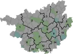
Hepu (Chinese: 合浦; pinyin: Hépǔ), alternately romanized as Hoppo, Hopu or Hop'u, is a county under the administration of Beihai City in southeastern Guangxi, China. It borders Lianjiang (Guangdong) to the southeast, Bobai County to the northeast, the Gulf of Tonkin to the south, Qinzhou to the west, and Pubei County to the north. Then-Premier Li Peng called this place "the Southern Pearl County" (南珠之乡) in November 1992. The county was once known as Lianzhou (Postal: Limchow). It has an area of 2,380 km2 (920 sq mi) and a population of 930,914 as of 2003.
Hepu County
合浦县 Hoppo; Limchow | |
|---|---|
 Hepu Location of the seat in Guangxi | |
| Coordinates: 21°40′N 109°12′E | |
| Country | People's Republic of China |
| Province | Guangxi |
| Prefecture-level city | Beihai |
| Township-level divisions | 13 towns, 2 townships |
| County seat | Lianzhou |
| Area | |
| • Total | 2,380 km2 (920 sq mi) |
| Elevation | 12 m (40 ft) |
| Population (2003) | |
| • Total | 930,914 |
| • Density | 390/km2 (1,000/sq mi) |
| Time zone | UTC+8 (China Standard) |
| Postal code | 536100 |
| Area code(s) | 0779 |
About 300,000 of the inhabitants are of Hakka descent.
History

In antiquity, Hepu county was originally part of a larger county which encompassed part of Guangxi, Guangdong and even parts of Hainan. It was established in 111 BCE by Emperor Wu of the Han dynasty, during the first Chinese domination of Vietnam. During the brief interruption of the Han dynasty by Wang Mang, many of his opponents were exiled and banished to Hepu.
- 1949–1950: Hepu administered Beihai as a town
- June 1965: administered by Qinzhou Region of Guangxi, prior
- July 1, 1987: administered by Beihai City
Administrative divisions
The county administers 13 towns and 2 townships:[1]
Towns:
- Lianzhou (廉州镇), Dangjiang (党江镇), Xichang (西场镇), Shagang (沙岗镇), Wujia (乌家镇), Zhakou (闸口镇), Gongguan (公馆镇), Baisha (白沙镇), Shankou (山口镇), Shatian (沙田镇), Shiwan (石湾镇), Shikang (石康镇), Changle (常乐镇)
Townships:
- Quzhang Township (曲樟乡), Xingdaohu Township (星岛湖乡)
Transportation
Climate
| Climate data for Hepu (1981−2010) | |||||||||||||
|---|---|---|---|---|---|---|---|---|---|---|---|---|---|
| Month | Jan | Feb | Mar | Apr | May | Jun | Jul | Aug | Sep | Oct | Nov | Dec | Year |
| Record high °C (°F) | 28.9 (84.0) |
32.0 (89.6) |
32.7 (90.9) |
34.5 (94.1) |
37.4 (99.3) |
37.1 (98.8) |
37.6 (99.7) |
37.5 (99.5) |
37.3 (99.1) |
35.0 (95.0) |
32.6 (90.7) |
29.7 (85.5) |
37.6 (99.7) |
| Average high °C (°F) | 19.1 (66.4) |
20.0 (68.0) |
22.9 (73.2) |
27.4 (81.3) |
30.8 (87.4) |
32.0 (89.6) |
32.4 (90.3) |
32.3 (90.1) |
31.7 (89.1) |
29.6 (85.3) |
25.8 (78.4) |
21.7 (71.1) |
27.1 (80.9) |
| Daily mean °C (°F) | 14.6 (58.3) |
16.1 (61.0) |
19.0 (66.2) |
23.6 (74.5) |
26.9 (80.4) |
28.5 (83.3) |
28.9 (84.0) |
28.5 (83.3) |
27.5 (81.5) |
24.9 (76.8) |
20.7 (69.3) |
16.6 (61.9) |
23.0 (73.4) |
| Average low °C (°F) | 11.7 (53.1) |
13.4 (56.1) |
16.4 (61.5) |
21.0 (69.8) |
24.0 (75.2) |
25.8 (78.4) |
26.1 (79.0) |
25.7 (78.3) |
24.5 (76.1) |
21.6 (70.9) |
17.2 (63.0) |
13.1 (55.6) |
20.0 (68.1) |
| Record low °C (°F) | 2.0 (35.6) |
2.2 (36.0) |
3.4 (38.1) |
9.5 (49.1) |
15.1 (59.2) |
19.8 (67.6) |
22.2 (72.0) |
21.1 (70.0) |
15.9 (60.6) |
11.5 (52.7) |
6.3 (43.3) |
1.5 (34.7) |
1.5 (34.7) |
| Average precipitation mm (inches) | 34.3 (1.35) |
54.4 (2.14) |
59.6 (2.35) |
92.8 (3.65) |
151.3 (5.96) |
291.1 (11.46) |
371.3 (14.62) |
355.1 (13.98) |
207.8 (8.18) |
80.5 (3.17) |
41.5 (1.63) |
20.8 (0.82) |
1,760.5 (69.31) |
| Average relative humidity (%) | 77 | 82 | 84 | 83 | 81 | 83 | 83 | 84 | 80 | 75 | 72 | 71 | 80 |
| Source: China Meteorological Data Service Center | |||||||||||||
References
- 2011年统计用区划代码和城乡划分代码:合浦县 (in Chinese). National Bureau of Statistics of the People's Republic of China. Archived from the original on 2012-12-08. Retrieved 2013-01-04.
- https://www.youtube.com/watch?v=5OapKDKGuG4