Hochstett
Hochstett is a commune in the Bas-Rhin department in Grand Est in north-eastern France.
Hochstett
Heestett | |
|---|---|
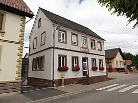 The town hall in Hochstett | |
Location of Hochstett 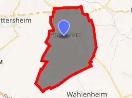
| |
 Hochstett  Hochstett | |
| Coordinates: 48°46′44″N 7°40′38″E | |
| Country | France |
| Region | Grand Est |
| Department | Bas-Rhin |
| Arrondissement | Haguenau-Wissembourg |
| Canton | Haguenau |
| Government | |
| • Mayor (2001–2008) | Clément Jung |
| Area 1 | 2.13 km2 (0.82 sq mi) |
| Population (2017-01-01)[1] | 373 |
| • Density | 180/km2 (450/sq mi) |
| Time zone | UTC+01:00 (CET) |
| • Summer (DST) | UTC+02:00 (CEST) |
| INSEE/Postal code | 67203 /67170 |
| Elevation | 172–217 m (564–712 ft) |
| 1 French Land Register data, which excludes lakes, ponds, glaciers > 1 km2 (0.386 sq mi or 247 acres) and river estuaries. | |
Geography
Hochstett is positioned near to the autoroute that connects Strasbourg with Metz and, eventually, Paris. It is adjacent to the autoroute exit 47 which is the exit for Haguenau, although the limited access nature of the autoroute junctions in the area makes access from the autoroute to the village unexpectedly indirect.
The village is at the crossing of various minor roads, the least minor being the departmental road RD 419.
A principal element in the local economy is agriculture.
See also
References
- "Populations légales 2017". INSEE. Retrieved 6 January 2020.
| Wikimedia Commons has media related to Hochstett. |
| Authority control |
|
|---|
This article is issued from Wikipedia. The text is licensed under Creative Commons - Attribution - Sharealike. Additional terms may apply for the media files.
