Ingenheim
Ingenheim is a commune in the Bas-Rhin department in Grand Est in north-eastern France.
Ingenheim
Íngne | |
|---|---|
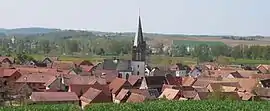 A general view of Ingenheim | |
.svg.png.webp) Coat of arms | |
Location of Ingenheim 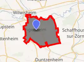
| |
 Ingenheim  Ingenheim | |
| Coordinates: 48°44′07″N 7°31′17″E | |
| Country | France |
| Region | Grand Est |
| Department | Bas-Rhin |
| Arrondissement | Saverne |
| Canton | Bouxwiller |
| Government | |
| • Mayor (2001–2008) | Jean Vix |
| Area 1 | 5.37 km2 (2.07 sq mi) |
| Population (2017-01-01)[1] | 333 |
| • Density | 62/km2 (160/sq mi) |
| Time zone | UTC+01:00 (CET) |
| • Summer (DST) | UTC+02:00 (CEST) |
| INSEE/Postal code | 67220 /67270 |
| Elevation | 157–229 m (515–751 ft) |
| 1 French Land Register data, which excludes lakes, ponds, glaciers > 1 km2 (0.386 sq mi or 247 acres) and river estuaries. | |
The name
The earliest surviving record dates from 739 and names the village Ingenhaim. The first two syllables may comes from the Germanic given/Christian name, "Ingo". "Heim" occurs frequently in place names in countries where the local language is or has been a dialect of German: it is from the same root as the English word "home" and may refer to a grouping of houses or to a farmstead.
History
Between 1802 and 1853 the village was the centre for a consistory for Protestant communities in the surrounding settlements of Dettwiller, Ernolsheim-lès-Saverne, Schwindratzheim, Alteckendorf, Waltenheim-sur-Zorn and Duntzenheim. It lost out to Schwindratzheim after 1852 when the parish replaced the consistory as the defining organisational unit for protestant churches in France.
Landmarks
The Protestant church, completed in 1911.
See also
References
- "Populations légales 2017". INSEE. Retrieved 6 January 2020.
| Wikimedia Commons has media related to Ingenheim. |
| Authority control |
|
|---|
