Hohentengen am Hochrhein
Hohentengen is a municipality in the district of Waldshut in Baden-Württemberg in Germany.
Hohentengen am Hochrhein | |
|---|---|
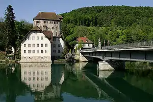 Schloss Rötteln | |
 Coat of arms | |
Location of Hohentengen am Hochrhein within Waldshut district 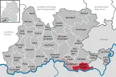 | |
 Hohentengen am Hochrhein  Hohentengen am Hochrhein | |
| Coordinates: 47°34′12″N 08°26′02″E | |
| Country | Germany |
| State | Baden-Württemberg |
| Admin. region | Freiburg |
| District | Waldshut |
| Government | |
| • Mayor | Martin Benz |
| Area | |
| • Total | 27.55 km2 (10.64 sq mi) |
| Elevation | 368 m (1,207 ft) |
| Population (2019-12-31)[1] | |
| • Total | 3,887 |
| • Density | 140/km2 (370/sq mi) |
| Time zone | UTC+01:00 (CET) |
| • Summer (DST) | UTC+02:00 (CEST) |
| Postal codes | 79801 |
| Dialling codes | 07742 |
| Vehicle registration | WT |
| Website | www.hohentengen.de |
Geography
Location
The village Hohentengen lies on the northern banks of the Rhine, overlooking Switzerland. The right weather conditions allow a view of the Swiss Alpes from the 'Kalten Wangen', a mountain in the district of Stetten. Hohentengen am Hochrhein comprises six districts: Hohentengen, Lienheim, Herdern, Bergöschingen, Günzgen and Stetten.
Neighbouring towns
Hohentengen borders to Klettgau in the north, the Swiss towns of Wasterkingen and Hüntwangen in the east, Glattfelden and Weiach in the south, which are all part of the Kanton Zürich, as well as Kaiserstuhl, Aargau, Fisibach, and Rümikon, which are part of the Kanton Aargau. In the west, Hohentengen borders to the German town of Küssaberg.
References
- "Bevölkerung nach Nationalität und Geschlecht am 31. Dezember 2019". Statistisches Landesamt Baden-Württemberg (in German). September 2020.
| Wikimedia Commons has media related to Hohentengen am Hochrhein. |
| Authority control |
|---|