Hop Bottom, Pennsylvania
Hop Bottom is a borough of Susquehanna County, Pennsylvania, United States. The population was 337 as of the 2010 census. The name comes from the hop, a plant providing flowers for brewing.
Hop Bottom, Pennsylvania | |
|---|---|
 | |
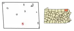 Location of Hop Bottom in Susquehanna County, Pennsylvania. | |
 Hop Bottom Location of Hop Bottom in Susquehanna County, Pennsylvania.  Hop Bottom Hop Bottom (the United States) | |
| Coordinates: 41°42′18″N 75°45′56″W | |
| Country | United States |
| State | Pennsylvania |
| County | Susquehanna |
| Settled | 1799 |
| Incorporated | 1881 |
| Area | |
| • Total | 0.61 sq mi (1.58 km2) |
| • Land | 0.61 sq mi (1.57 km2) |
| • Water | 0.00 sq mi (0.01 km2) |
| Population (2010) | |
| • Total | 337 |
| • Estimate (2019)[2] | 313 |
| • Density | 516.50/sq mi (199.57/km2) |
| Time zone | UTC-5 (Eastern (EST)) |
| • Summer (DST) | UTC-4 (EDT) |
| ZIP code | 18824 |
| Area code(s) | 570 and 272 |
| FIPS code | 42-35624 |
History
Hop Bottom was formerly known as "Foster." The present name comes from nearby Hop Bottom Creek.[3] Native Americans once lived in the area, and the only clear meadows to be found were near the bottom of the creek. These meadows were covered with hop vines, leading the name "Hop Bottom."[4]
Geography
Hop Bottom is located at 41°42′18″N 75°45′56″W.[5]
According to the United States Census Bureau, the borough has a total area of 0.6 square miles (1.6 km2), all of it land.
Hop Bottom is located at the junction of U.S. Route 11 and Pennsylvania Route 167. It is also seven miles west of Interstate 81.
Demographics
| Historical population | |||
|---|---|---|---|
| Census | Pop. | %± | |
| 1890 | 299 | — | |
| 1900 | 326 | 9.0% | |
| 1910 | 364 | 11.7% | |
| 1920 | 349 | −4.1% | |
| 1930 | 354 | 1.4% | |
| 1940 | 375 | 5.9% | |
| 1950 | 375 | 0.0% | |
| 1960 | 381 | 1.6% | |
| 1970 | 430 | 12.9% | |
| 1980 | 405 | −5.8% | |
| 1990 | 345 | −14.8% | |
| 2000 | 333 | −3.5% | |
| 2010 | 337 | 1.2% | |
| 2019 (est.) | 313 | [2] | −7.1% |
| Sources:[6][7][8] | |||
According to the census[9] of 2010, there were 337 people, 138 households, and 88 families residing in the borough. The population density was 561.7 people per square mile (219.4/km2). There were 147 housing units at an average density of 245 per square mile (95.7/km2). The racial makeup of the borough was 98.5% White and 1.5% from two or more races. Hispanic or Latino of any race were 1.2% of the population.
Of the 138 households, 26.8% had children under the age of 18 living with them, 44.9% were married couples living together, 13.8% had a female householder with no husband present, and 36.2% were non-families. 28.3% of all households were made up of individuals, and 6.5% had someone living alone who was 65 years of age or older. The average household size was 2.44 and the average family size was 3.03.
In the borough the population was spread out, with 22.6% under the age of 18, 63.8% from 18 to 64, and 13.6% who were 65 years of age or older. The average (median) age was 39 years.
The median income for a household in the borough was $42,917, and the median income for a family was $53,125. Males had a median income of $44,167 versus $28,542 for females. The per capita income for the borough was $19,665. About 17.9% of families and 20.8% of the population were below the poverty line, including 27.7% of those under age 18 and 16.1% of those age 65 or over.
References
- "2019 U.S. Gazetteer Files". United States Census Bureau. Retrieved July 28, 2020.
- "Population and Housing Unit Estimates". United States Census Bureau. May 24, 2020. Retrieved May 27, 2020.
- Espenshade, Abraham Howry (1925). Pennsylvania Place Names. Evangelical Press. p. 302. ISBN 978-0-8063-0416-8.
- http://lcweb2.loc.gov/diglib/legacies/PA/200002940.html
- "US Gazetteer files: 2010, 2000, and 1990". United States Census Bureau. 2011-02-12. Retrieved 2011-04-23.
- "Census of Population and Housing". U.S. Census Bureau. Retrieved 11 December 2013.
- "U.S. Census website". United States Census Bureau. Retrieved 2008-01-31.
- "Incorporated Places and Minor Civil Divisions Datasets: Subcounty Resident Population Estimates: April 1, 2010 to July 1, 2012". Population Estimates. U.S. Census Bureau. Archived from the original on 11 June 2013. Retrieved 11 December 2013.
- "U.S. Census website". United States Census Bureau. Retrieved 2011-05-14.
Municipalities and communities of Susquehanna County, Pennsylvania, United States | ||
|---|---|---|
| Boroughs | 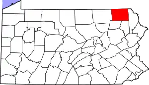 | |
| Townships | ||
| Unincorporated communities | ||
| ||
| Authority control |
|---|