Hormuz Island
Hormuz Island (/hɔːrˈmuːz/; Persian: جزیره هرمز Jazireh-ye Hormoz), also spelled Hormoz, is an Iranian island in the Persian Gulf. Located in the Strait of Hormuz, 8 kilometres (5 mi) off the Iranian coast, the island is part of Hormozgan Province. Reddish ochre on the island and its beaches, called Golak by natives, has been exploited for artistic and culinary purposes and also attracts tourists. Degradation due to overuse of the ochre has resulted in actions by the Department of Environment to protect it.[1]
Hormuz Island | |
|---|---|
 | |
 | |
| Coordinates: 27°04′N 56°28′E | |
| Country | |
| Province | Hormozgān |
| Area | |
| • Land | 42 km2 (16.2 sq mi) |
| Elevation | 186 m (610 ft) |
| Time zone | UTC+3:30 (IRST) |
Geography
Hormuz Island has an area of 42 km2 (16 sq mi). It is covered by sedimentary rock and layers of volcanic material on its surface. The highest point of the island is about 186 metres (610 ft) above sea level. Due to a lack of precipitation, the soil and water are salty. Specialists have helped cultivar white mangrove or Hara trees to grow in the climate. Due to the lack of fresh water, Iranian engineers have constructed a water pipeline from the mainland. There are many virgin beaches that go all around the island.
History
The island, known as Organa (Όργανα) to the ancient Greeks and as Jarun in the Islamic period, acquired the name of "Hormuz" from the important harbour town of Hormuz (Ormus) on the mainland 60 km away, which had been a centre of a minor principality on both sides of the strait. The principality paid tribute to the Mongol-ruled Ilkhanate and was an important source of income from maritime trade.[2] The town's ruler decided to shift his residence to the island around 1300, in order to evade attacks by Mongolian and Turkish groups from the interior.[3] The ruler later made peace with the Ilkhans.
A new town was built on the northern tip of Jarun island which was called New Hormuz for a number of years to distinguish it from the old town on the mainland until this fell into ruins. Slowly the name of the new town came to be used for the island as well.
The island is arid, and during the summer months the temperature can rise to over 43 °C (109 °F). As such, it was not an ideal location for the capital of a principality as all provisions including water had to be brought from the mainland. Its location, however, gave the island a degree of security which let it grow to be a major trading port for several centuries. As its competitors suffered from intermittent destruction, Hormuz remained a reliable and relatively safe harborage.
Hormuz was visited by Marco Polo, around 1290, while traveling by land, as described in his travelogue.
Ibn Battuta also visited the island, and New Hormuz.[4]
In 1505 the reign King Manuel I of Portugal led Portugal to establish a policy of expansion in Africa and western Asia. During attempts to expand Portuguese influence into the Indian Ocean, the Portuguese duke Afonso de Albuquerque captured the island in 1507 and it was incorporated into the greater Portuguese Empire. The Portuguese constructed a fortress on the island to deter potential invaders, naming it the Fort of Our Lady of the Conception. The island became an emergency stopover point for Portuguese ships travelling to Goa, Gujarat and nearby Kishm. The Ottomans laid siege to the island under the admiral and cartographer Piri Reis in 1552.[5] In 1622 the island was captured from the Portuguese by a combined Anglo-Persian force at the behest of the English East India Company.
Shah Abbas I distrusted the local population and was not interested in maintaining the island as a trading centre or military post; instead he developed the nearby mainland port of Bander Abbas. Hormuz went into decline. Many of its inhabitants seasonally moved to their fields and orchards around the old Hormuz on the mainland, only fishermen being in permanent residence. The island continued to export small quantities of rock salt and lumps of iron oxide which were used as ballast stones for sailing ships.[6]
After a period of Omani administration in the 19th century, it remained a sparsely inhabited fishermen's island before experiencing some development in the later years of the 20th century.
Statues Valley
With a few hundred meters walk to the beach, in a way that silver sands attracts attention, rocks can be seen in many different forms, each is likened to an animal, a sheep's head, poultry and many different Dragons.
The rocks show that, over thousands of years that the island of Hormuz gradually comes out of the water, the wear and tear on it makes different shapes. According to researches, geological age of the Hormuz island is about 600 million years ago and its life when coming out of the water is about 50 thousand years.[7]
Dr. Nadalian Museum and Gallery
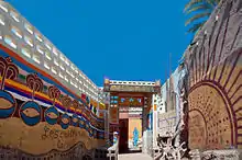
The Museum and Gallery of Dr. Ahmad Nadalian in Hormoz Island shows the works of this artists who is internationally known as one of the most active environmental artists. His environmental art projects, include the carving of rocks that can be found in more than seventy countries. In March 2009, the Paradise Art Centre on Hormoz Island in the Persian Gulf was established here. Four years later in 2012 it has become the museum of Dr.Nadalian. and its entrance was redesigned with inspiration from local architecture.[8]
Gallery
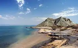
 Hormuz Island beach
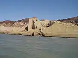 Hormoz Island
.jpg.webp) The Fort of Our Lady of the Conception, Hormuz Island
The Fort of Our Lady of the Conception, Hormuz Island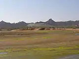 Hara forests at Hormuz Island
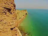
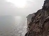 The sea cliffs near the Valley of Statues of Hormuz Island
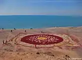 Art made from ochre on the islands beaches
Notes
- Hormuz, the rainbow island of Iran. Tehran Times (2017-10-14). Retrieved 2020-03-28.
- Cambridge history of India, vol. 1, p.147
- H. Yule, The Book of Ser Marco Polo, 1903, vol. I, p. 110, quoting Abulfeda ("Hormuz was devastated by the incursions of the Tartars, and its people transferred their abode to an island in the sea called Zarun, near the continent, lying west of the old city.") and Odoric for the date.
- Battutah, Ibn (2002). The Travels of Ibn Battutah. London: Picador. pp. 98–99, 308. ISBN 9780330418799.
- Pîrî Reis’in Hürmüz Seferi ve İdamı Hakkındaki Türk ve Portekiz Tarihçilerinin Düşünceleri Ertuğrul Önalp. Prof. Dr. Ankara Üniversitesi, Dil ve Tarih-Coğrafya Fakültesi, İspanyol Dili ve Edebiyatı Anabilim Dalı. (in Turkish)
- "HORMUZ ii. ISLAMIC PERIOD – Encyclopaedia Iranica". www.iranicaonline.org. Retrieved Mar 31, 2020.
- "دره مجسمه ها Statues Valley". هتل جزیره هرمز | Hotel in Hormuz island. Retrieved Mar 31, 2020.
- "WWW.RiverArt.Net- Environmental Works by A. Nadalian هنر رودخانه: آثار دكتر احمد نادعليان". www.riverart.net. Retrieved Mar 31, 2020.
References
- . الكوخردى ، محمد ، بن يوسف، (كُوخِرد حَاضِرَة اِسلامِيةَ عَلي ضِفافِ نَهر مِهران) الطبعة الثالثة ،دبى: سنة 199۷ للميلاد Mohammed Kookherdi (1997) Kookherd, an Islamic civil at Mehran river, third edition: Dubai
- . کامله،القاسمی، بنت شیخ عبدالله، (تاریخ لنجة) مکتبة دبي للتوزیع، الامارات: الطبعة الثانية عام ۱۹۹۳ للمیلاد
- . الوحیدی الخنجی، حسین بن علی بن احمد، «تاریخ لنجه» ، الطبعة الثانية دبی: دار الأمة للنشر والتوزیع، ۱۹۸۸ للمیلاد
- . اطلس گیتاشناسی استانهای ایران [Atlas Gitashenasi Ostanhai Iran] (Gitashenasi Province Atlas of Iran)
- . دره مجسمه ها[Statue Valley Hormuz Island] ()
External links
| Wikimedia Commons has media related to Hormuz Island. |
| Capital | 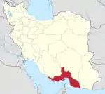 | ||||||||||||||||||||||||
|---|---|---|---|---|---|---|---|---|---|---|---|---|---|---|---|---|---|---|---|---|---|---|---|---|---|
| Counties and cities |
| ||||||||||||||||||||||||
| Sights |
| ||||||||||||||||||||||||
| populated places | |||||||||||||||||||||||||
| See also | |||||||||||||||||||||||||
Iranian islands in the Persian Gulf | ||
|---|---|---|
| ||
| Authority control |
|
|---|