Horná Súča
Horná Súča (Hungarian: Felsőszúcs) is a village and municipality in Trenčín District in the Trenčín Region of north-western Slovakia.
Horná Súča | |
|---|---|
Municipality | |
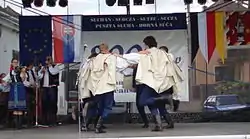 800 year festival | |
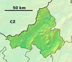 Horná Súča Location of Horná Súča in the Trenčín Region  Horná Súča Location of Horná Súča in Slovakia | |
| Coordinates: 48°58′N 17°59′E | |
| Country | |
| Region | Trenčín |
| District | Trenčín |
| First mentioned | 1208 |
| Government | |
| • Mayor | Juraj Ondračka |
| Area | |
| • Total | 53.82 km2 (20.78 sq mi) |
| Elevation | 315 m (1,033 ft) |
| Population (2016-12-31) | |
| • Total | 3,415 |
| • Density | 63/km2 (160/sq mi) |
| Time zone | UTC+1 (CET) |
| • Summer (DST) | UTC+2 (CEST) |
| Postal code | 913 33 |
| Area code(s) | 421-32 |
| Car plate | TN |
| Website | www |
History
In historical records the village was first mentioned in 1208.
Geography
The municipality lies at an altitude of 315 metres and covers an area of 53.824 km². It has a population of about 3415 people.
Genealogical resources
The records for genealogical research are available at the state archive "Statny Archiv in Bratislava, Slovakia"
- Roman Catholic church records (births/marriages/deaths): 1688-1895 (parish A)
- Lutheran church records (births/marriages/deaths): 1783-1895 (parish B)
External links
 Media related to Horná Súča at Wikimedia Commons
- Official website

- https://web.archive.org/web/20080111223415/http://www.statistics.sk/mosmis/eng/run.html
- Surnames of living people in Horna Suca
| Authority control |
|
|---|
This article is issued from Wikipedia. The text is licensed under Creative Commons - Attribution - Sharealike. Additional terms may apply for the media files.