Mníchova Lehota
Mníchova Lehota (Hungarian: Barátszabadi ) is a village and municipality in Trenčín District in the Trenčín Region of north-western Slovakia.
Mníchova Lehota | |
|---|---|
Municipality | |
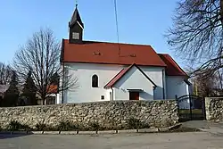 Church of the Holy Trinity | |
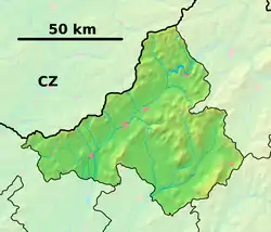 Mníchova Lehota Location of Mníchova Lehota in the Trenčín Region  Mníchova Lehota Location of Mníchova Lehota in Slovakia | |
| Coordinates: 48°50′N 18°04′E | |
| Country | |
| Region | Trenčín |
| District | Trenčín |
| First mentioned | 1269 |
| Area | |
| • Total | 16.616 km2 (6.415 sq mi) |
| Elevation | 260 m (850 ft) |
| Population | |
| • Total | 1,115 |
| • Density | 67/km2 (170/sq mi) |
| Time zone | UTC+1 (CET) |
| • Summer (DST) | UTC+2 (CEST) |
| Postal code | 913 21 (pošta Trenčianska Turná) |
| Area code(s) | 421-32 |
| Car plate | TN |
| Website | mnichovalehota |
History
In historical records the village was first mentioned in 1269.
Geography
The municipality lies at an altitude of 260 metres and covers an area of 16.616 km². It has a population of about 1115 people.
External links
 Media related to Mníchova Lehota at Wikimedia Commons
- Official website

- http://www.statistics.sk/mosmis/eng/run.html
This article is issued from Wikipedia. The text is licensed under Creative Commons - Attribution - Sharealike. Additional terms may apply for the media files.