Hornøya (Finnmark)
Hornøya is a small, 0.4 square kilometres (99 acres), uninhabited island in Vardø Municipality in Troms og Finnmark county, Norway. It lies in the Barents Sea, just east of the larger island of Vardøya where the town of Vardø is located. Vardø Lighthouse is situated at the highest point of the island, at an elevation of 65 metres (213 ft) above sea level, and it protects the shipping lanes around the town of Vardø. The island is the easternmost point of Norway proper.[1][2]
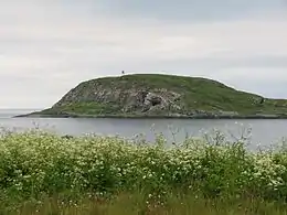 View of Hornøya and Vardø Lighthouse | |
 Hornøya Location in Troms og Finnmark | |
| Geography | |
|---|---|
| Location | Troms og Finnmark, Norway |
| Coordinates | 70.3877°N 31.1553°E |
| Area | 0.4 km2 (0.15 sq mi) |
| Length | 900 m (3000 ft) |
| Width | 700 m (2300 ft) |
| Highest elevation | 65 m (213 ft) |
| Administration | |
| County | Troms og Finnmark |
| Municipality | Vardø |
See also
References
- Norwegian Mapping Authority. "Ytterpunkter for kongeriket Norge" (in Norwegian). Archived from the original on 13 May 2008. Retrieved 7 February 2009.
- Store norske leksikon. "Hornøya" (in Norwegian). Retrieved 2013-03-01.
This article is issued from Wikipedia. The text is licensed under Creative Commons - Attribution - Sharealike. Additional terms may apply for the media files.
