Horncastle
Horncastle is a town and civil parish in Lincolnshire, 17 miles (27 km) east of the county town of Lincoln. Its population of 6,815 at the 2011 census was estimated to be 7,123 in 2019.[1] A section of the ancient Roman walls remains.
| Horncastle | |
|---|---|
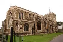 St Mary's Church, Horncastle | |
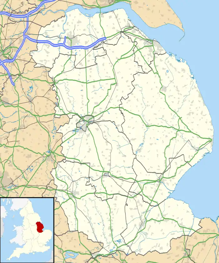 Horncastle Location within Lincolnshire | |
| Area | 5.73 km2 (2.21 sq mi) |
| Population | 6,815 (2011) |
| • Density | 1,189/km2 (3,080/sq mi) |
| OS grid reference | TF2669 |
| • London | 115 mi (185 km) S |
| Civil parish |
|
| District | |
| Shire county | |
| Region | |
| Country | England |
| Sovereign state | United Kingdom |
| Post town | HORNCASTLE |
| Postcode district | LN9 |
| Dialling code | 01507 |
| Police | Lincolnshire |
| Fire | Lincolnshire |
| Ambulance | East Midlands |
| UK Parliament | |
History
Romans
Although fortified, Horncastle was not on any important Roman roads, which suggests that the River Bain was the principal route of access to it.
Roman Horncastle has become known recently as Banovallum (i. e. Wall on the River Bain). Although the name has been adopted by some local businesses and the town's secondary modern school, it is not firmly known to be Horncastle's Roman name.[2] Banovallum was merely suggested in the 19th century through an interpretation of the Ravenna Cosmography, a 7th-century list of Roman towns and road-stations,[3] and may equally have been Caistor.
The Roman walls remain in places. One section of them is on display in the town's library, which was built over the top of the wall.[2] The Saxons called the town Hyrnecastre, from which its modern name derives.

Domesday Book
Horncastle is listed in the 1086 Domesday Book as consisting of 41 households, including 29 villagers and twelve smallholders, and had 100 acres (0 km2) of meadow and two mills, all belonging to King William.[4]
Church
Dating from the 13th century, prior to the Reformation, the Anglican parish church is dedicated to Saint Mary the Virgin. It is a Grade II* listed building in the Early English style, but was extensively restored between 1859 and 1861 by Ewan Christian.[5]
English Civil War
Four miles from Horncastle is the village of Winceby. During the 1643 Battle of Winceby, which helped to secure Lincolnshire for Parliament, its leader, Oliver Cromwell, was almost killed.[6] Local legend has it that the 13 scythe blades which hang on the wall of the south chapel of St Mary's Church were used as weapons at Winceby, but this assertion is generally regarded as apocryphal. The accepted historical opinion is that they probably date from the Lincolnshire Rising of 1536.[7] Both theories about the origin of the scythes are discussed in the "Church History" Lincoln website.[8]
Blood sports
Horncastle was once known as a centre for cockfighting and bull-baiting.[9] A pub there still bears the name The Fighting Cocks. Bull-baiting was practised in the area of town known as the Bull Ring. One historian has estimated that the practise continued until about 1810.[10] Both these sports were banned in England and Wales under the Cruelty to Animals Act of 1835.[11]
Market and horse fair

Horncastle was granted its market charter by the Crown in the 13th century. It was long known for its great August horse fair, an internationally famous annual trading event which continued to be held until the mid-20th century. It ended after the Second World War, when horses were generally no longer used for agriculture. The town is now known as a centre for the antiques trade.[12][13]
The great annual horse fair was probably first held in the 13th century. The fair used to last for a week or more every August. In the 19th century it was likely the largest event of its kind in the United Kingdom. The slogan, "Horncastle for horses", was an indication of the town's standing in this trade. George Borrow set some scenes of his semi-autobiographical books Lavengro and The Romany Rye at the annual horse fair. The last horse fair was held in 1948.[14] Livestock markets continued to be held in Horncastle for pigs and cattle, and the last cattle market was held in the year 2000.[15]
In 1894 the Stanhope Memorial, designed by E. Lingen Barker, was erected in the centre of the Market Place in memory of Edward Stanhope MP. Built of limestone, red sandstone and pink and grey streaked marble, it is a Grade II listed structure.[16]
Notable buildings
The Grade II listed Old Court House in the town centre in Louth Road was built in 1865. There are 116 other listed edifices in the town, including the three places of worship – St Mary's (Grade II*), Holy Trinity (Grade II) and the Congregational Church (Grade II) – and several sections of the Roman walls (Grade I).[17]
Population
Historically, the civil parish suffered a population decline from the mid-19th to mid-20th centuries, as urbanisation and agricultural changes drew people to cities, where more work was available. However, the population since the late 20th century increased to 6,815 in 2011, its highest so far. The estimated population in 2019 was still higher at 7,123.[18]
| Population of Horncastle civil parish | |||||||||||||||
|---|---|---|---|---|---|---|---|---|---|---|---|---|---|---|---|
| Year | 1801 | 1811 | 1821 | 1831 | 1841 | 1851 | 1881 | 1891 | 1901 | 1911 | 1921 | 1931 | 1951 | 1961 | 2011 |
| Population[19] | 2,015 | 2,602 | 3,058 | 3,988 | 4,521 | 5,017 | 4,818 | 4,374 | 4,038 | 3,900 | 3,459 | 3,496 | 3,809 | 3,771 | 6,815 |
Geography
Horncastle lies 7 miles from Woodhall Spa, 10 miles from Spilsby, 18 miles from Boston, 21 miles from Lincoln, 10 miles from Wragby and 13 miles from Louth. Horncastle is also near the main A158 road which runs from Lincoln to Skegness. It lies to the south of the Lincolnshire Wolds, where the (north–south) River Bain meets the River Waring (from the east), and north of the West and Wildmore Fens. The south of Horncastle is called Cagthorpe. Langton Hill to the west used to be part of Horncastle Rural District in the Parts of Lindsey, but is now in the district of East Lindsey based in Manby, east of Louth.
North of the town, the civil parish meets West Ashby and Low Toynton, south of Milestone House on the A153 Louth Road. The boundary skirts the east of the town, crossing Low Toynton Road, following the Viking Way. Then meeting the River Waring. It briefly follows north of the A158, where it meets High Toynton. Southwards on Mareham Road, it then meets Mareham on the Hill, east of Stonehill Farm. South of the town and north of Telegraph House, it reaches Scrivelsby, following High Lane westwards to cross the B1183, south of Loxley Farm, then the A153, and skirts the southern edge of the sewage works next to the River Bain, where it meets Roughton (Thornton). It takes the line of the Old River Bain west of the A153 northwards over the river meadows, crossing the Horncastle Canal and Viking Way. Eastwards it crosses the B1191, south of Langton Hill, where at Lowmoor Lane it meets Langton. It follows Langton Lane northwards, with Mill House Farm (Langton Mill) to the west, towards Thimbleby. It meets the B1190, then the A158 at the B1190 junction, following Accommodation Road to the east. It skirts the north of the town, along Elmhurst Road, passing south of Elmlea Farm and straight through to Elmhirst Lakes. At the River Bain near Hemingby Lane, it reaches West Ashby.
Destinations from Horncastle | ||||||||||
|---|---|---|---|---|---|---|---|---|---|---|
| ||||||||||
Economy
Lincolnshire Integrated Voluntary Emergency Service is based at the Boston Road Industrial Estate. The Lincolnshire Wildlife Trust is based in Banovallum House. Mortons of Horncastle is a major national magazine publisher of classic motorcycles, aviation and road transport heritage titles, based in the industrial estate off the A153 (Boston Road).[20]
Governance
An electoral ward of the same name exists. It includes Thimbleby and had a total population at the 2011 Census of 7,073.[21]
Politics
Horncastle has always been a safe area for the Conservative Party, except for two years in the early 1920s, when it had Liberal Party representation. It had an eponymous parliamentary constituency for 98 years, from 1885 to 1983. It then became Gainsborough and Horncastle, and after 1997, Louth and Horncastle. Henry Haslam served as MP during the Second World War and the five years of the Churchill wartime government. The veteran politician Sir Peter Tapsell was MP for the town from 1966 to 1983 and from 1997 to 2015, being Father of the House of Commons from 2010 to 2015. After a redistribution of parliamentary constituencies, Edward Leigh was MP from 1983 to 1997.
Education
Primary schools
Horncastle Primary School is situated at Bowl Alley Lane.[22]
Secondary schools
Queen Elizabeth's Grammar School[23] was founded in 1571, and is among the top schools in Lincolnshire;[24] it has at times been one of the top schools in the country. Its tennis, hockey, netball and cricket teams compete regionally, and the tennis team was a regional winner in the 2005 British Schools Tennis Championships. Queen Elizabeth's is a specialist Science College and Language College. Its Design and Technology department recently entered two teams in the National 4X4 for Schools engineering competition, one of which came first nationally in its age group, while the other came second nationally overall.
The Banovallum School[25] is a non-selective community school serving Horncastle and surrounding villages; it forms a science specialist school jointly with Queen Elizabeth's Grammar School. The most recent Ofsted inspection, in 2019, judged the school to be overall Grade 2 (good).[26] It had a building added with facilities for cookery, woodwork, metalwork, art and music in 2010
St Lawrence School is a special-needs school with a county-wide intake. It comprises the Lincolnshire Wolds Federation with St Bernard's School, Louth.[27][28]
Colleges
Horncastle College was a "lifelong-learning" adult education college that runs short and residential courses in I.T., art, languages and local history.[29] It has now been replaced by Fortuna Horncastle Business Centre.[30]
Transport
Roads

Horncastle sits at the crossroads of two of Lincolnshire's major roads: the east-west A158, joining the county town of Lincoln with the resort of Skegness on the Lincolnshire coast, and the north-south A153 joining Louth with Sleaford and Grantham in the south. These meet at the Bull Ring in central Horncastle.
The A158 through Horncastle becomes busy in the summer holidays with Skegness holidaymakers. To alleviate traffic pressure in the town centre a relief road, Jubilee Way, was built in the 1970s. Minor roads run from Horncastle to Bardney, Boston (via Revesby), Fulletby and Woodhall Spa.
Horncastle is a hub for the InterConnect rural bus service. Regular services run to Lincoln, Skegness and across the Wolds. The Viking Way long-distance footpath passes through the town.[31]
Railway
The Great Northern Railway's Lincoln–Boston line ran through Kirkstead, 8 miles (12.9 km) from Horncastle, and a branch line from Kirkstead (later Woodhall Junction) through Woodhall Spa to Horncastle opened on 11 August 1855. The last passenger service ran in 1954, with complete closure to goods traffic in 1971.[32] Horncastle railway station was demolished in the 1980s and replaced by housing. The nearest railway station now is Metheringham (15 miles, 24 km) on the Peterborough to Lincoln Line.[33] Part of the old railway is followed by the Viking Way footpath.[31]
Waterways

Horncastle Canal, based on the River Bain, was begun in 1792 and opened in 1802.[34]
In 2004 it was suggested that the Horncastle Canal (originally opened in 1802) be renovated with the help of private capital and promoted as a route for pleasure craft, as has been done successfully in other areas.[35] A local kick-start programme raised money for the project.[36]
Sport
Field games
Horncastle Town FC, founded in 1873, is an amateur football club based at The Wong.[37] It joined the Lincolnshire Football League in the 1996/1997 season.[38]
The town has a cricket club at Coronation Walk, with two men's and five youth teams.[39]
Horncastle Hockey Club is a voluntary field-hockey body set up in November 1970 at Coronation Walk, Horncastle.[40] In 2020 it had two men's and two women's teams and a junior section.
Court games
Horncastle and District Tennis Club has offered tennis for over 70 years. Initially on grass courts in Stanhope Road, the club moved to the current Coronation Walk location in the 1970s.[41]
Horncastle Community Members Squash Club in Hemmingby Lane was founded in November 2006 to preserve an existing club by buying out owners who had run it for 25 years and wished to retire.[42]
Floods

The town has been susceptible to flooding,[43] notably in 1920 and 1960, and with three floods occurring between 1981 and 1984.
Folk belief associates the occurrence of floods with installations of new vicars in Horncastle's Anglican Church. The vicar changed in 1919 and 1959, both less than a year before a flood. The flooding of the early 1980s was attributed to the change of vicar in 1980, but there was no flooding after the change of vicar in 1999. The River Bain and River Waring overflowed during the 2007 United Kingdom floods.[43][44][45]
Flooding occurred again in 2012.[46] A £15 million, 30-year-old proposed flood-defence scheme was seen as unlikely to have prevented the 2012 flood, but new flood defences are being discussed.[47] An anti-flood pump was installed in 2013.[48]
On 7 October 1960 Horncastle entered the UK Weather Records with a "highest 180-minute total" rainfall of 178 mm.[43][49] Water levels are said to have risen 8 feet (2.4 m) as a consequence.[45]
Real-time river levels are available from the Environment Agency:
Flood warnings for the town:
Twin town
Horncastle is twinned with Bonnétable, a ville de marché (market town) in the French department of Sarthe, with a population of about 4,000.[50][51] The towns' relationship is commemorated by a Rue Horncastle in Bonnétable and a Bonnetable Road in Horncastle (without the acute accent).
Notable people
- Rev. William Blaxton (also William Blackstone) (1595 – 26 May 1675)[52] was an early English settler in New England and the first European settler of modern-day Boston and Rhode Island.
- Sir Joseph Banks (1743–1820) was botanist to Captain James Cook.
- Peter "Biff" Byford (born 1951) is lead singer of heavy metal band Saxon.
- Annie Dixon (1817–1901), miniature portrait painter
- Sir Lionel Dymoke (died 1519)[53]
- Robert Merrick Fowler (1778–1860), a Royal Navy officer, served with Matthew Flinders and at the Battle of Pulo Aura (1804).[54]
- Tim Garbutt, DJ/producer and one half of the dance music act Utah Saints[55]
- Connie Lewcock (1894–1980), suffragette
- Henry Simpson Lunn (1859–1939), religious leader and co-founder of Lunn Poly travel agents
- William Marwood (1818–1883), public hangman
- Erasmus Middleton (1739–1805), clergyman, author and editor
- Ben Pridmore (living), memory champion, attended school in Horncastle.
- Samuel Roberts (1827–1913), mathematician and Fellow of the Royal Society
- Thomas Sully (1783–1872), portrait painter
- Emily Tennyson, Lady Tennyson (1813–1896)[53]
- Alfred, Lord Tennyson (1809–1892), Poet Laureate, was born six miles from Horncastle in the village of Somersby. Tennyson opined, "Of all horrors, a little country town seems to me to be the greatest."
- Arthur Thistlewood (1774–1820), radical and Cato Street conspirator, was baptised in Horncastle on 4 December 1774.[56]
- Robert Webb (born 1972), actor and comedian, lived in Woodhall Spa, but went to school in Horncastle.
- Harold A. Wilson (1885–1932), 1908 Olympic athlete, was the first to run an under four-minute 1500 metres.
References
- City Population. Retrieved 7 January 2021.
- Historic England. "Bannovellum (352692)". PastScape. Retrieved 2 October 2010.
- Roman-Britain.org
- "Horncastle". Open Domesday. Anna Powell-Smith/University of Hull. Retrieved 23 October 2011.
- Historic England. "St Marys Church, Horncastle (Grade II) (1168259)". National Heritage List for England. Retrieved 24 October 2011.
- "Local web site, detailed account of civil war actions". Archived from the original on 25 January 2013. Retrieved 9 April 2011.
- "Account of Lincolnshire Rising". Horncastle Discovered. Archived from the original on 12 July 2011.
- "Church History". Lincoln. Retrieved 9 April 2011.
- BBC Lincolnshire – Lincolnshire Day. Retrieved 24 April 2019.
- Records of Woodhall Spa and Neighbourhood. Retrieved 24 April 2019.
- – Cruelty to Animals Act. Retrieved 24 April 2019.
- "Town Council details". Retrieved 9 April 2011.
- "Lincolnshire things to do | Lincolnshire days out | what to do in Lincoln". Archived from the original on 5 February 2013.
- "Horse fair details". Horncastle Discovered. Archived from the original on 12 July 2011.
- Lincolnshire Life - Join the Celebrations. Retrieved 24 April 2019.
- Historic England. "Stanhope Memorial (1262721)". National Heritage List for England. Retrieved 23 October 2011.
- British Listed Buildings.
- City Population. Retrieved 18 December 2020.
- "Vision of Britain". Retrieved 23 October 2011.
- "Geograph:: Approaching Horncastle from the South © Tony Atkin cc-by-sa/2.0". www.geograph.org.uk.
- "Ward population 2011". Retrieved 19 August 2015.
- "Government record for primary school". Archived from the original on 9 May 2012. Retrieved 9 April 2011.
- "Government record for Grammar school". Archived from the original on 9 May 2012. Retrieved 9 April 2011.
- "The Queen Elizabeth's Grammar School, Horncastle", BBC News
- "Government record for Secondary school". Archived from the original on 9 May 2012. Retrieved 9 April 2011.
- "The Banovallum School, Horncastle", Ofsted report 2010. Retrieved 14 June 2012
- "Special school web site".
- "Government record for Secondary school". Archived from the original on 9 May 2012. Retrieved 9 April 2011.
- "Horncastle College". Archived from the original on 19 May 2011. Retrieved 9 April 2011.
- "Fortuna Horncastle Business Centre". Retrieved 2 April 2020.
- The Viking Way: Official Guidebook to the 147 Mile Long Distance Footpath Through Lincolnshire and Rutland. Lincolnshire Books. 1997. ISBN 1-872375-25-1.
- Historic England. "Horncastle Station (499040)". PastScape. Retrieved 15 March 2013.
- Historic England. "Horncastle railway (1365443)". PastScape. Retrieved 15 March 2013.
- Historic England. "Horncastle Canal (892922)". PastScape. Retrieved 19 August 2010.
- "Cash pours in for project to revitalise canal". Horncastle News. 5 February 2004. Retrieved 22 March 2013.
- "Kickstart for canal". Horncastle News. 29 October 2003. Retrieved 22 March 2013.
- "StackPath". www.horncastletownfc.co.uk. Retrieved 11 February 2020.
- "StackPath". www.horncastletownfc.co.uk. Retrieved 11 February 2020.
- "Horncastle CC". horncastle.play-cricket.com. Retrieved 11 February 2020.
- "About Us | Horncastle & District Tennis Club | Horncastle". hdtc. Retrieved 11 February 2020.
- http://www.cromwellstudios.co.uk, Cromwell Studios Web Services-Website Design. "Horncastle Squash Club | About.php". squash.cromwellstudios.co.uk. Retrieved 11 February 2020.
- David N Robinson. "Horncastle and the Problem of Floods". The Old Chapel, Church Close, Boston, Lincolnshire PE21 6NP: Visitor UK Ltd. Retrieved 22 February 2013.CS1 maint: location (link)
- "Visiting Horncastle". Lincolnshire Tourist Guide Ltd. Archived from the original on 25 April 2013. Retrieved 22 March 2013. Mentions both the rainfall record and the folklore link of floods with installations of Vicars.
- "Floods make national news". Horncastle News. 12 August 2012. Retrieved 22 March 2013.
- "Lincolnshire clean-up operation after flash floods". News Lincolnshire. BBC. 29 June 2012. Retrieved 22 March 2013.
- "£15m defence scheme will not stop town homes flooding". Horncastle News. 14 July 2012. Retrieved 22 March 2013.
- "Major boost to Horncastle flood defences". Horncastle News. 3 March 2013. Retrieved 22 March 2013.
- "Extremes: UK rainfall records for short durations". Met Office. Archived from the original on 3 April 2012. Retrieved 22 March 2013. Highest 180-minute total 178 mm 7 October 1960 Horncastle (Lincolnshire)
- "Twinning association record". Archived from the original on 17 February 2012. Retrieved 9 April 2011.
- "Twinning Association site". Retrieved 9 April 2011.
- 1944-, Anderson, Robert Charles. The great migration begins: immigrants to New England, 1620–1633. New England Historic Genealogical Society. Boston. ISBN 088082042X. OCLC 33083117.CS1 maint: numeric names: authors list (link)
- Elliott, Ray (July 2001). St Mary's Horncastle – a church tour. The Parochial Church Council of the Ecclesiastical Parish of St Mary's, Horncastle.
- Brown, Anthony (2000). Ill-starred captains: Flinders and Baudin. Crawford House Pub. p. 489. ISBN 978-1-86333-192-0.
- "Spa DJ hit the charts with Utah Saints, Horncastle News
- Malcolm Chase, "Thistlewood, Arthur (baptised 1774, died 1820)" (Oxford, UK: OUP, 2004) Retrieved 2 December 2016. Pay-walled.
External links
| Wikisource has the text of the 1911 Encyclopædia Britannica article Horncastle. |
 Media related to Horncastle at Wikimedia Commons
- A History of Horncastle (1908) by James Conway Walter
- Horncastle Civic Society
- Horncastle Today - local news and sport website
- Horncastle Discovered
England Portal | |
| Unitary authorities | |
| Boroughs or districts | |
| Major settlements |
|
| Topics | |
| Authority control |
|---|