Horta of Valencia
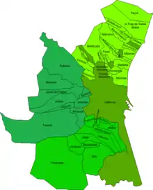
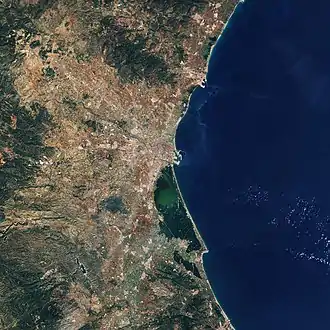
The Horta of Valencia (Valencian: L'Horta de València; Spanish: Huerta de Valencia) is a historical comarca and urban area of Valencian Community. The Horta of Valencia consists of Valencia and three comarcas: Horta Nord, Horta Sud, Horta Oest.
Horta of Valencia | |
|---|---|
historical comarca and urban area | |
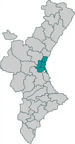 Huerta de Valencia on map of Valencian Community | |
 Horta of Valencia Huerta de Valencia on map of Valencian Community  Horta of Valencia Horta of Valencia (European Union) | |
| Coordinates: 39°28′N 0°22′W | |
| Country | |
| Autonomous community | |
| Province | Valencia |
| City and comarcas | Valencia, Horta Nord, Horta Sud, Horta Oest |
| Area | |
| • Total | 627.65 km2 (242.34 sq mi) |
| Population | |
| • Total | 1,495,883 |
| • Density | 2,400/km2 (6,200/sq mi) |
| Demonym(s) | Valencian |
Demography
It is the most populated region of País Valencià. The Horta of Valencia has also experienced the greatest increase in population, especially as an immigrant receiver. Its urban expansion has motivated the creation of several urbanisations [LEX], and the incorporation to the urban nucleus of the metropolis of the earlier towns. Nowadays, the expansion has also contributed to its separation in four regions that are currently considered sub-regions.
Geography
The region is located within Puçol (in the North), the Albufera (in the South), and Paterna, Torrent and Montcada (in the West). It is a lowland region that elevates progressively from the sea towards the inland.
The Horta at the Territory [LEX] of Valencia
It might be surprising that people preserve the Valencian agricultural traditions so near [LEX, GRAM] the city of Valencia and also [EST] the presence of traditional cabins for agricultural purposes, called barraques''' [SEM]', as well as the traditional paths along the Horta, even if the city has caused negative effects because of the building of many landfills, waste ground, and workshops. This situation, together with the construction of new high-speed rails and dual carriageways, has cut up the Horta into different parts. Also, it has left little areas of countryside surrounded by huge infrastructures. That is a problem that has an impact not only in farmers' lives, but also in neighbours'.
Here is a list of the different areas in the territory of Valencia:
Horta of Campanar
The Horta of Campanar is located in the North West of the Campanar district. In the north, it shares its border with the dual carriageway that connects Valencia and Paterna. In the west, it is in front of Horta of Paterna, and in the south, it borders with Horta of Quart de Poblet, Mislata and the river Turia. In the east, it shares border with Ronda Nord [SEM] of Valencia and the neighbourhoods of Beniferri and Campanar.
Horta of Faitanar
The Horta of Faitanar is the section of Horta of Valencia that is located in the south [ORT] of the new river bed of the Turia River and in the west [ORT] of Forn d'Alcedo. In the south [ORT] , it borders with Picanya and Paiporta, and in the north [ORT] west [ORT] , it is in front of Xirivella where the Horta continues without cracking.
Horta of the Moreres or of the Punta
The Horta of the Moreres or of the Punta [ORT] belongs to the farmland of the towns La Font [GRAM, FS] de Sant Lluis, La Font d'Encorts, La Punta and Natzaret. It extends its territory from Ronda Sud [SEM] and the City of Arts and Sciences to the new river bed of the Turia River [ORT] .
Horta of the Castellar-l'Oliveral
In the neighbourhood of Castellar-l'Oliveral, there is a territory of the Horta between the new river bed of the Turia River [ORT] and Sedaví.
Horta of Vera
The Horta of Vera is the ancient Horta of Benimaclet and Alboraia. Nowadays, the south [ORT] belongs to Valencia and the north [ORT] to Alboraia. A great part of it has been urbanised and transformed into the neighbourhoods of Camí of Vera and Vega Baixa. In the north, there are still some farmlands and barraques [SEM].
Horta of Orriols
In the north of the neighbourhoods of Orriols (previously, a village) and of Sant Llorenç, between the limit of Alboraia and Ronda Nord of Valencia, Horta of Orriols lives on and continues all along until the city of Alboraia.
Horta of Pobles del Nord
Thanks to the isolation from the big cities, big areas of the Horta live on in the region of Pobles del Nord.
Pinedo and El Palmar
Although mainly all [EST] the land is dedicated to the cultivation of rice, a significant number barraques [SEM] and other elements related to the Horta, such as ditches, live on in the villages of Pinedo and El Palmar.
Origin
The Valencian Horta came up [NMS, PRAG] in the time of the Roman Empire. The city of Valentia was founded as the logistics centre and the hibernation [FS, LEX] place for the Roman campaigns for the conquest of the Iberia.
The Romans contributed to these lands with the crops they knew, such as the cultivation of cereals, olive or vine. Nevertheless, on account of the typical conditions of the environment, the crops were not productive enough. Still, the crops were useful in supplying the Roman armies and, later, for the campaigns of the Visigoths, who left the fields and the cityFS].
The Valencian Horta as we know it today was developed in the medieval times, during the Islamic period. An important fluvial infrastructure was created, mainly thanks to the construction of ditches and assuts (little dams that led the waters of the Turia River and the precipices that could drain marshy areas and bring down the watering [TERM] to the fields). Likewise, different activities were boosted and developed near those infrastructures, such as the watermills, which profited the [GRAM] water flow of the ditches and the washbasins near the houses and farmsteads.
Thanks to those infrastructures, the city of Valencia, as well as its surrounding villages, was able to expand successfully.
A rich production area was created. The origin of Horta of Valencia comes from the Al-Alandalus period, as a consequence of the introduction of the Arabic irrigation tradition (Yemen and Syria), just like the North African berebers did [FS]. The cultivations were really unequal [CS], due to an independent and tributary society. In addition to the typical crops of the Roman period (cereal, vine, olive), the rice and the tiger nut (Cyperus esculentus) and new vegetables from Al-Andalus, such as aubergine, artichoke, etc [GRAM]. Those new crops are [REG] typical from the damp zones. The crops par excellence are [REG] the [AD] horticultural products, hence the name of this environment.
There are eight principal ditches: Montcada, Tormos, Mestalla, Rascanya, Quart-Benàger-Faitanar, Mislata, Favara and Rovella. Except for Montcada, the rest are ruled by the "Tribunal de les Aigües", which is an institution than [GRAM] controls the use and the utilisation [AD] of the irrigation flow. This institution is still working nowadays and its members assemble [LEX] at the door of the Cathedral of Valencia once a week.
Economy
Agriculture
In the typical Mediterranean climate, the Horta has mild winters and very hot [FS] summers. The historical activity of the region had [la coherència entre temps verbals d'una frase a una altra és necessària pel bé del lector si no hi ha un canvi significat d'època al text] been agriculture, with a predominance of three types of crops: orange, vegetables and rice. The watering system is structured around 13 ditches [NMS: ditch és una rasa per a drenar el terra, sèquia és un concepte molt valencià que hauria d'usar-se a la traducció precedit d'una explicació la primera volta que apareix al text] that allow irrigation crops all year. Some municipal areas have a certain expertise regarding crops: tiger nut in Alboraia and Almàssera; tomatoes and peppers for canning El Puig [GRAM], Puçol and Tavernes Blanques; strawberries in Rafelbunyol; melons and watermelos [ORT] in Meliana and Almàssera, and so on. Rice is distressed [LEX], but it is still being cultivated on the edges of the Albufera.
Industry
To the west [ORT] of the region, towns are situated on the edge of the Horta, around the capital city: Montcada, with textile and fireworks [GRAM] industries; Burjassot, together with Godella, with ceramic and cement factories; Paterna, Manises and Quart de Poblet, which have an important ceramic industry; Mislata, which presents paper and textile industries, and so on. In the north [ORT] , the towns follow a parallel line to [GRAM] the coast: Tavernes Blanques, with ceramic and porcelain industries; Massamagrell, Meliana, Puçol, basically agricultural, etc. In the south, there are several towns physically attached [LEX] to each other: Benetússer, Alfafar, Poblenou de la Corona, Sedaví, Massanassa, Catarroja and Silla. The capital city of the region, Valencia, which is also that of País Valencià with more than 760 000 [ORT] inhabitants, currently maintains the agriculture that made it famous in the past, but it has also developed a lot [REG] of industry (furniture, chemical, mechanical) and trade.
