Howard, Kansas
Howard is a city in and the county seat of Elk County, Kansas, United States.[7] As of the 2010 census, the city population was 687.[8]
Howard, Kansas | |
|---|---|
City and County seat | |
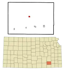 Location within Elk County and Kansas | |
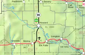 KDOT map of Elk County (legend) | |
| Coordinates: 37°28′7″N 96°15′47″W | |
| Country | United States |
| State | Kansas |
| County | Elk |
| Founded | 1870 |
| Incorporated | 1877 |
| Named for | Oliver O. Howard |
| Government | |
| • Type | Mayor–Council |
| • Mayor | Richard Clark |
| Area | |
| • Total | 0.69 sq mi (1.80 km2) |
| • Land | 0.69 sq mi (1.80 km2) |
| • Water | 0.00 sq mi (0.00 km2) |
| Elevation | 1,037 ft (316 m) |
| Population | |
| • Total | 687 |
| • Estimate (2019)[4] | 606 |
| • Density | 871.94/sq mi (336.65/km2) |
| Time zone | UTC-6 (CST) |
| • Summer (DST) | UTC-5 (CDT) |
| ZIP code | 67349 |
| Area code | 620 |
| FIPS code | 20-33250 [5] |
| GNIS ID | 469959 [6] |
| Website | cityofhoward.org |
History
Howard was founded in 1870, and it was incorporated as a city in 1877.[9] Howard was named after Oliver O. Howard, a Union Army general during the Civil War and founder of Howard University.[10][11] The first post office in Howard was established in February, 1870.[12] As of 1901, Howard was a sundown town where African Americans were not allowed to live.[13]
Geography
Howard is located at 37°28′7″N 96°15′47″W (37.468517, -96.263014).[14] According to the United States Census Bureau, the city has a total area of 0.70 square miles (1.81 km2), all of it land.[15]
Climate
The climate in this area is characterized by hot, humid summers and generally mild to cool winters. According to the Köppen Climate Classification system, Howard has a humid subtropical climate, abbreviated "Cfa" on climate maps.[16]
Demographics
| Historical population | |||
|---|---|---|---|
| Census | Pop. | %± | |
| 1880 | 683 | — | |
| 1890 | 1,015 | 48.6% | |
| 1900 | 1,207 | 18.9% | |
| 1910 | 1,163 | −3.6% | |
| 1920 | 1,060 | −8.9% | |
| 1930 | 1,069 | 0.8% | |
| 1940 | 1,170 | 9.4% | |
| 1950 | 1,149 | −1.8% | |
| 1960 | 1,017 | −11.5% | |
| 1970 | 918 | −9.7% | |
| 1980 | 965 | 5.1% | |
| 1990 | 815 | −15.5% | |
| 2000 | 808 | −0.9% | |
| 2010 | 687 | −15.0% | |
| 2019 (est.) | 606 | [4] | −11.8% |
| U.S. Decennial Census | |||
2010 census
As of the census[3] of 2010, there were 687 people, 318 households, and 176 families residing in the city. The population density was 981.4 inhabitants per square mile (378.9/km2). There were 415 housing units at an average density of 592.9 per square mile (228.9/km2). The racial makeup of the city was 95.1% White, 1.6% Native American, 0.4% Asian, 0.6% from other races, and 2.3% from two or more races. Hispanic or Latino of any race were 4.1% of the population.
There were 318 households, of which 22.3% had children under the age of 18 living with them, 43.1% were married couples living together, 8.8% had a female householder with no husband present, 3.5% had a male householder with no wife present, and 44.7% were non-families. 41.2% of all households were made up of individuals, and 22.7% had someone living alone who was 65 years of age or older. The average household size was 2.03 and the average family size was 2.74.
The median age in the city was 49.6 years. 19.9% of residents were under the age of 18; 6.7% were between the ages of 18 and 24; 17.6% were from 25 to 44; 27.3% were from 45 to 64; and 28.5% were 65 years of age or older. The gender makeup of the city was 47.3% male and 52.7% female.
2000 census
As of the census[5] of 2000, there were 808 people, 350 households, and 215 families residing in the city. The population density was 1,154.6 people per square mile (445.7/km2). There were 452 housing units at an average density of 645.9 per square mile (249.3/km2). The racial makeup of the city was 94.93% White, 0.25% African American, 1.24% Native American, 0.62% Asian, 0.62% from other races, and 2.35% from two or more races. Hispanic or Latino of any race were 1.98% of the population.
There were 350 households, out of which 24.0% had children under the age of 18 living with them, 51.7% were married couples living together, 6.3% had a female householder with no husband present, and 38.3% were non-families. 37.4% of all households were made up of individuals, and 23.7% had someone living alone who was 65 years of age or older. The average household size was 2.16 and the average family size was 2.83.
In the city, the population was spread out, with 22.4% under the age of 18, 5.4% from 18 to 24, 19.2% from 25 to 44, 22.8% from 45 to 64, and 30.2% who were 65 years of age or older. The median age was 47 years. For every 100 females, there were 81.6 males. For every 100 females age 18 and over, there were 78.6 males.
The median income for a household in the city was $25,822, and the median income for a family was $28,365. Males had a median income of $24,886 versus $16,354 for females. The per capita income for the city was $15,441. About 11.9% of families and 14.5% of the population were below the poverty line, including 17.2% of those under age 18 and 14.6% of those age 65 or over.
Education
Howard is served by USD 282 West Elk Schools. School unification consolidated Moline, Howard and Severy schools forming USD 282. West Elk High School is located in Howard. The West Elk High School mascot is Patriots.[17]
Prior to school unification, the Howard High School mascot was Pirates.[18]
References
- "City of Howard". The League of Kansas Municipalities. May 29, 2019.
- "2019 U.S. Gazetteer Files". United States Census Bureau. Retrieved July 24, 2020.
- "U.S. Census website". United States Census Bureau. Retrieved 2012-07-06.
- "Population and Housing Unit Estimates". United States Census Bureau. May 24, 2020. Retrieved May 27, 2020.
- "U.S. Census website". United States Census Bureau. Retrieved 2008-01-31.
- "US Board on Geographic Names". United States Geological Survey. 2007-10-25. Retrieved 2008-01-31.
- "Find a County". National Association of Counties. Archived from the original on 2011-05-31. Retrieved 2011-06-07.
- "2010 City Population and Housing Occupancy Status". U.S. Census Bureau. Retrieved June 18, 2011.
- Blackmar, Frank Wilson (1912). Kansas: A Cyclopedia of State History, Embracing Events, Institutions, Industries, Counties, Cities, Towns, Prominent Persons, Etc. Standard Publishing Company. p. 876.
- Rydjord, John (1972). Kansas Place-Names. Norman: University of Oklahoma Press. p. 202. ISBN 0-8061-0994-7.
- "Profile for Howard, Kansas". ePodunk. Archived from the original on 14 July 2014. Retrieved 9 June 2014.
- "Kansas Post Offices, 1828-1961 (archived)". Kansas Historical Society. Archived from the original on 9 October 2013. Retrieved 8 June 2014.
- "Kansas Items". Fairview Enterprise. Fairview, Kansas. February 9, 1901. p. 3 – via Newspapers.com.
Nortonville and Howard are two Kansas towns where negroes are not allowed to live.
- "US Gazetteer files: 2010, 2000, and 1990". United States Census Bureau. 2011-02-12. Retrieved 2011-04-23.
- "US Gazetteer files 2010". United States Census Bureau. Archived from the original on 2012-01-25. Retrieved 2012-07-06.
- Climate Summary for Howard, Kansas
- "West Elk Schools". USD 282. Retrieved 4 January 2017.
- "Howard High School - Scraps Yearbook (Howard, KS) - Class of 1959". E-YEARBOOK.COM. Retrieved 7 January 2017.
Further reading
External links
| Wikimedia Commons has media related to Howard, Kansas. |
- City
- Schools
- USD 282, local school district
- USD 282 School District Boundary Map, KDOT
- Maps
- Howard City Map, KDOT
Municipalities and communities of Elk County, Kansas, United States | ||
|---|---|---|
| Cities | 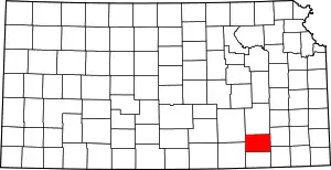 Map of Kansas highlighting Elk County | |
| Unincorporated communities | ||
| Townships | ||
| ||
| Authority control |
|---|