Howe Valley, Kentucky
Howevalley is an unincorporated community in Hardin County, Kentucky, United States. Howe Valley is located on Kentucky Route 86 12.3 miles (19.8 km) west of Elizabethtown.[2]
Howevalley, Kentucky | |
|---|---|
 Howevalley  Howevalley | |
| Coordinates: 37°41′14″N 86°05′18″W | |
| Country | United States |
| State | Kentucky |
| County | Hardin |
| Elevation | 682 ft (208 m) |
| Time zone | UTC-5 (Eastern (EST)) |
| • Summer (DST) | UTC-4 (EDT) |
| Area code(s) | 270 & 364 |
| GNIS feature ID | 494687[1] |
A post office operated in the community from 1852 to 1908. Howevalley (also historically spelled Howe's Valley and Howevalley) is situated in a valley of the same name, which in turn was named for John Howe, an early settler.[3] John Howe was in the American Revolutionary War and was given the land for his work.
References
- "Howe Valley". Geographic Names Information System. United States Geological Survey.
- State Primary Road System: Hardin County (PDF) (Map). Kentucky Transportation Cabinet. 2012. Retrieved May 1, 2013.
- Rennick, Robert M. (1987). Kentucky Place Names. University Press of Kentucky. p. 146. ISBN 0813126312. Retrieved 2013-04-28.
Municipalities and communities of Hardin County, Kentucky, United States | ||
|---|---|---|
| Cities | 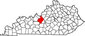 Location of Hardin County, Kentucky | |
| CDPs | ||
| Other unincorporated communities | ||
| Footnotes | ‡This populated place also has portions in an adjacent county or counties | |
| ||
This article is issued from Wikipedia. The text is licensed under Creative Commons - Attribution - Sharealike. Additional terms may apply for the media files.
