Kentucky Route 86
Kentucky Route 86 (KY 86) is a 43.683-mile-long (70.301 km) state highway in Kentucky that runs from KY 144 in the unincorporated community of Union Star to U.S. Route 62 (US 62) southeast of Cecilia.
| ||||
|---|---|---|---|---|
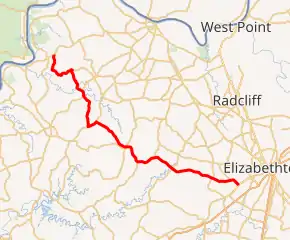
KY 86 highlighted in red | ||||
| Route information | ||||
| Maintained by KYTC | ||||
| Length | 43.683 mi[1] (70.301 km) | |||
| Major junctions | ||||
| West end | ||||
| East end | ||||
| Location | ||||
| Counties | Breckinridge, Hardin | |||
| Highway system | ||||
| ||||

Major intersections
| County | Location | mi[1] | km | Destinations | Notes |
|---|---|---|---|---|---|
| Breckinridge | Union Star | 0.000 | 0.000 | Western terminus | |
| Lodiburg | 6.123 | 9.854 | West end of KY 261 overlap | ||
| | 9.986 | 16.071 | Western terminus of KY 2780 | ||
| | 10.776 | 17.342 | East end of KY 261 overlap | ||
| Garfield | 15.957 | 25.680 | West end of US 60/KY 79 overlap | ||
| | 17.358 | 27.935 | East end of US 60/KY 79 overlap | ||
| Custer | 23.366 | 37.604 | Eastern terminus of KY 1401 | ||
| 23.395 | 37.651 | ||||
| | 26.717 | 42.997 | Eastern terminus of KY 401 | ||
| Hardin | | 32.825 | 52.827 | ||
| | 39.328 | 63.292 | |||
| | 42.139 | 67.816 | Southern terminus of KY 253 | ||
| | 43.683 | 70.301 | Eastern terminus | ||
| 1.000 mi = 1.609 km; 1.000 km = 0.621 mi | |||||
References
- Commonwealth of Kentucky. "Official DMI Route Log". Retrieved 26 December 2012.
This article is issued from Wikipedia. The text is licensed under Creative Commons - Attribution - Sharealike. Additional terms may apply for the media files.