Huntingburg, Indiana
Huntingburg is a city in Patoka Township, Dubois County, in the U.S. state of Indiana.[6] The population was 6,057 at the 2010 census.
Huntingburg, Indiana | |
|---|---|
 | |
| Nickname(s): "Hollywood of the Midwest" | |
| Motto(s): "A City Like No Other!" | |
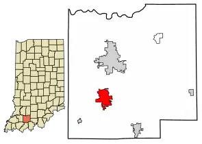 Location of Huntingburg in Dubois County, Indiana. | |
| Coordinates: 38°17′49″N 86°57′16″W | |
| Country | United States |
| State | Indiana |
| County | Dubois |
| Township | Patoka |
| Government | |
| • Mayor | Dennis Spinner (R) |
| Area | |
| • Total | 5.26 sq mi (13.63 km2) |
| • Land | 5.05 sq mi (13.08 km2) |
| • Water | 0.21 sq mi (0.55 km2) |
| Elevation | 489 ft (149 m) |
| Population | |
| • Total | 6,057 |
| • Estimate (2019)[4] | 6,170 |
| • Density | 1,221.54/sq mi (471.62/km2) |
| Time zone | UTC-5 (Eastern (EST)) |
| • Summer (DST) | UTC-4 (EDT) |
| ZIP code | 47542 |
| Area code(s) | 812, 930 |
| FIPS code | 18-35284[5] |
| GNIS feature ID | 436632 |
| Website | http://www.huntingburg-in.gov/ |
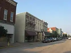
Located in southwestern Indiana, the city is known for its downtown with numerous antique shops. It is part of the Jasper Micropolitan Statistical Area. The city is also known as the "Hollywood of the Midwest." The movies A League of Their Own (1992), Hard Rain (1998), and the HBO film Soul of the Game (1996) were filmed in Huntingburg. Columbia Pictures renovated the grandstand at League Stadium that was to become part of the set for A League of Their Own.
League Stadium was home to the Dubois County Dragons who played in the Heartland League (1996–1998) and the Frontier League (1999–2002). From 1996 to 2001, Huntingburg was the smallest city to host a professional baseball team. After the Dragons franchise moved, Jeff Martindale League Stadium stood empty in the summers until the Bluff City Bombers of the Central Illinois Collegiate League moved to Huntingburg in 2005 and were renamed the Dubois County Bombers. The CICL then merged with the Prospect League. As the Prospect League has a larger geographical footprint, the Bombers moved to the Ohio Valley League as of the 2013 season.
History
Huntingburg was platted in 1837 by Colonel Jacob Geiger who purchased 1,920 acres (7.8 km2) of land and became one of the city's first permanent settlers.[7][8] It was likely so named because the site had been a popular hunting ground.[9] Huntingburg was incorporated as a town in 1866.[8]
The Huntingburg Commercial Historic District and Huntingburg Town Hall and Fire Engine House are listed on the National Register of Historic Places.[10]
The Huntingburg post office has been in operation since 1842.[11]
As part of Dubois County, Huntingburg re-entered the Eastern Time Zone on November 4, 2007 after 15 months on the Central Time Zone.[12]
On May 14th 2020 during the 2019-20 coronavirus pandemic, the city's local meat processing plant run by Farbest Foods reported 42 cases of COVID-19 among the employees. resulting in an 2-day closure beginning on May 18th.[13]
Geography

Huntingburg is located at 38°17′49″N 86°57′16″W (38.296853, -86.954344).[14]
According to the 2010 census, Huntingburg has a total area of 5.273 square miles (13.66 km2), of which 5.06 square miles (13.11 km2) (or 95.96%) is land and 0.213 square miles (0.55 km2) (or 4.04%) is water.[15]
Demographics
| Historical population | |||
|---|---|---|---|
| Census | Pop. | %± | |
| 1880 | 781 | — | |
| 1890 | 3,167 | 305.5% | |
| 1900 | 2,527 | −20.2% | |
| 1910 | 2,464 | −2.5% | |
| 1920 | 3,261 | 32.3% | |
| 1930 | 3,440 | 5.5% | |
| 1940 | 3,816 | 10.9% | |
| 1950 | 4,056 | 6.3% | |
| 1960 | 4,146 | 2.2% | |
| 1970 | 4,794 | 15.6% | |
| 1980 | 5,376 | 12.1% | |
| 1990 | 5,242 | −2.5% | |
| 2000 | 5,598 | 6.8% | |
| 2010 | 6,057 | 8.2% | |
| 2019 (est.) | 6,170 | [4] | 1.9% |
| Source: US Census Bureau | |||
2010 census
As of the census[3] of 2010, there were 6,057 people, 2,334 households, and 1,554 families residing in the city. The population density was 1,197.0 inhabitants per square mile (462.2/km2). There were 2,492 housing units at an average density of 492.5 per square mile (190.2/km2). The racial makeup of the city was 87.3% White, 0.5% African American, 0.2% Native American, 0.3% Asian, 9.9% from other races, and 1.8% from two or more races. Hispanic or Latino of any race were 18.5% of the population.
There were 2,334 households, of which 37.4% had children under the age of 18 living with them, 46.4% were married couples living together, 13.8% had a female householder with no husband present, 6.3% had a male householder with no wife present, and 33.4% were non-families. 28.5% of all households were made up of individuals, and 11.8% had someone living alone who was 65 years of age or older. The average household size was 2.55 and the average family size was 3.11.
The median age in the city was 35.1 years. 27.9% of residents were under the age of 18; 7.8% were between the ages of 18 and 24; 27.3% were from 25 to 44; 23.6% were from 45 to 64; and 13.5% were 65 years of age or older. The gender makeup of the city was 47.7% male and 52.3% female.
2000 census
As of the census[5] of 2000, there were 5,598 people, 2,162 households, and 1,444 families residing in the city. The population density was 1,543.3 people per square mile (595.4/km2). There were 2,267 housing units at an average density of 625.0 per square mile (241.1/km2). The racial makeup of the city is mostly White, 92.2%, Hispanic 9.8%, African American 0.2% two races or more 0.8%.
There were 2,162 households, out of which 33.3% had children under the age of 18 living with them, 50.8% were married couples living together, 11.2% had a female householder with no husband present, and 33.2% were non-families. 28.5% of all households were made up of individuals, and 12.9% had someone living alone who was 65 years of age or older. The average household size was 2.51 and the average family size was 3.05.
In the city, the population was spread out, with 26.2% under the age of 18, 9.1% from 18 to 24, 28.3% from 25 to 44, 20.5% from 45 to 64, and 15.9% who were 65 years of age or older. The median age was 36 years. For every 100 females, there were 91.3 males. For every 100 females age 18 and over, there were 88.9 males.
The median income for a household in the city was $33,415, and the median income for a family was $41,925. Males had a median income of $29,756 versus $22,167 for females. The per capita income for the city was $15,882. About 6.8% of families and 10.8% of the population were below the poverty line, including 11.3% of those under age 18 and 9.9% of those age 65 or over.
Education
The town has a free lending library, the Huntingburg Public Library.[16]
Transportation
Airport
Huntingburg Airport is a public use airport located three nautical miles (6 km) south of the central business district of Huntingburg. It is owned by the Dubois County Airport Authority.[17]
Notable people
- Tim Barrett, Major and minor league baseball player
- Ray Blemker, Major and minor league baseball player; Georgia Tech baseball and basketball star, All-SEC
- Don Buse, ABA Champion (1973) and NBA player; NCAA Champion (1971)
- Bob Coleman, Major League Baseball player and minor league manager
- Alex Graman, Major League Baseball pitcher for New York Yankees; Japan League pitcher for Saitama Seibu Lions; Japan Series Champion (2008), Asia Series Champion (2008)
- Bill Menke, basketball player for 1940 national champion Indiana Hoosiers
- Benjamin F. Miessner, engineer and inventor
- W. Otto Miessner, composer and music teacher
- Gordon St. Angelo, former Indiana Democratic Party chairman
- Mitch Stetter, pitcher for Milwaukee Brewers for five years; coach in Kansas City Royals organization
See also
References
- "2019 U.S. Gazetteer Files". United States Census Bureau. Retrieved July 16, 2020.
- "US Board on Geographic Names". United States Geological Survey. 2007-10-25. Retrieved 2008-01-31.
- "U.S. Census website". United States Census Bureau. Retrieved 2012-12-11.
- "Population and Housing Unit Estimates". United States Census Bureau. May 24, 2020. Retrieved May 27, 2020.
- "U.S. Census website". United States Census Bureau. Retrieved 2008-01-31.
- "Huntingburg, Indiana". Geographic Names Information System. United States Geological Survey. Retrieved 2016-07-05.
- "Col. Jacob Geiger's Favorite Hunting Grounds". 10 February 2002.
- Wilson, George R. (1910). History of Dubois County from Its Primitive Days to 1910. Published by the author. pp. 365–366.
- Gannett, Henry (1905). The Origin of Certain Place Names in the United States. Govt. Print. Off. pp. 163.
- "National Register Information System". National Register of Historic Places. National Park Service. July 9, 2010.
- "Dubois County". Jim Forte Postal History. Retrieved 6 July 2016.
- Smith, Mike (September 21, 2007). "5 counties do time warp again". The Journal Gazette. Associated Press.
- "42 COVID-19 cases confirmed at Farbest". Dubois County Herald. May 14, 2020.
- "US Gazetteer files: 2010, 2000, and 1990". United States Census Bureau. 2011-02-12. Retrieved 2011-04-23.
- "G001 - Geographic Identifiers - 2010 Census Summary File 1". United States Census Bureau. Archived from the original on 2020-02-13. Retrieved 2015-07-28.
- "Indiana public library directory" (PDF). Indiana State Library. Retrieved 7 March 2018.
- FAA Airport Form 5010 for HNB PDF. Federal Aviation Administration. Effective May 31, 2012.
External links
Municipalities and communities of Dubois County, Indiana, United States | ||
|---|---|---|
| Cities | Map of Indiana highlighting Dubois County | |
| Towns | ||
| Townships | ||
| CDP | ||
| Other unincorporated communities | ||
| Ghost town | ||
| Footnotes | ‡This populated place also has portions in an adjacent county or counties | |
| ||
| Authority control |
|---|