Hutton Bonville
Hutton Bonville is a hamlet and civil parish in the Hambleton District of North Yorkshire, England.[1] The population of the civil parish as of the 2011 census was less than 100. Details are included in the civil parish of Danby Wiske with Lazenby. On its own road and near the A167, 6 miles (9.7 km) north of Northallerton.
| Hutton Bonville | |
|---|---|
.jpg.webp) The gatepiers to the now-demolished Hutton Bonville Hall | |
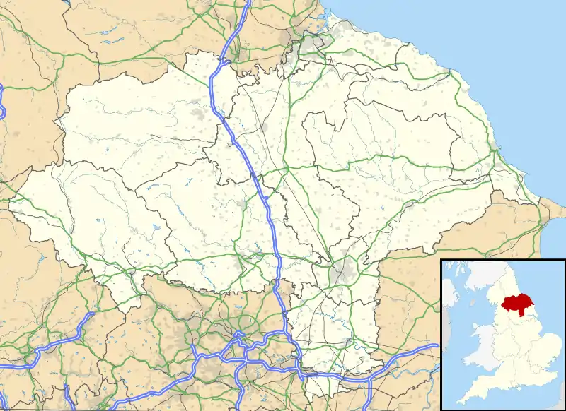 Hutton Bonville Location within North Yorkshire | |
| OS grid reference | NZ336002 |
| Civil parish |
|
| District | |
| Shire county | |
| Region | |
| Country | England |
| Sovereign state | United Kingdom |
| Post town | NORTHALLERTON |
| Postcode district | DL7 |
| Police | North Yorkshire |
| Fire | North Yorkshire |
| Ambulance | Yorkshire |
In the Imperial Gazetteer of England and Wales (1870–72) John Marius Wilson described Hutton Bonville:
HUTTON-BONVILLE, a chapelry in Birkby parish, N. R. Yorkshire; on the river Wiske and the Northeastern railway, 3 miles SSE of Cowton r. station, and 4 NNW of Northallerton. It contains the village of Lovesome-Hill, and its post town is Northallerton. Acres, 1, 080. Rea property, £1, 776. Pop., 129. Houses, 22. Hutton-Bonville Hall is a chief residence. The place is a meet for the Bedale hounds. The living is a p. curacy in the diocese of York. Value, £53. Patron, Mrs. M. A. Pierse. The church is good, and has a bellturret.[2]
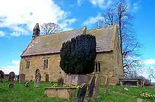
When Nikolaus Pevsner visited the hamlet in the early 1960s, to write the entry for his Yorkshire: The North Riding volume of the Buildings of England, he described the estate church of St Lawrence as "away from anywhere except the decaying Hall".[3] The Hall was demolished in the 1960s, although the gate piers at the start of the drive remain and are a Grade II listed structure.[4] St Lawrence's was declared redundant in 2007. It is now in the care of the Friends of Friendless Churches.[5]
References
- Ordnance Survey: Landranger map sheet 93 Middlesbrough (Darlington & Hartlepool) (Map). Ordnance Survey. 2010. ISBN 9780319228777.
- "A Vision of Britain Through Time: Hutton-Bonville". www.visionofbritain.co.uk. GB Historical GIS/University of Portsmouth. Retrieved 18 March 2016.
- Pevsner 1966, p. 198.
- Historic England. "Gate Piers Approximately 100m to the south of Hall Farm (Grade II) (1315156)". National Heritage List for England. Retrieved 9 December 2020.
- "Hutton Bonville". Friends of Friendless Churches. Retrieved 8 December 2020.
Sources
- Pevsner, Nikolaus (1966). Yorkshire: The North Riding. The Buildings of England. London: Penguin Books. OCLC 1156437241.
External links
![]() Media related to Hutton Bonville at Wikimedia Commons
Media related to Hutton Bonville at Wikimedia Commons