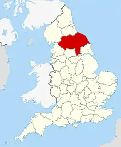
North Yorkshire
North Yorkshire is the largest non-metropolitan county and lieutenancy area in England, covering an area of 8,654 square kilometres (3,341 sq mi). It is located primarily in the region of Yorkshire and the Humber, but partly in the region of North East England. The ONS estimated that the population of the shire was 602,300 in mid-2016, excluding unitary authorities.[4]
Created by the Local Government Act 1972,[5] the majority of the Yorkshire Dales and the North York Moors lie within North Yorkshire's boundaries, and around 40% of the county is covered by national parks. The county is one of four counties in England to hold the name Yorkshire; the others are the East Riding of Yorkshire, South Yorkshire and West Yorkshire.
Within the ceremonial county, the most populous settlement is the Middlesbrough built-up area (at 174,700). The York built-up area (at 152,841) is the second most populous settlement. The largest settlement in the administrative county is Harrogate (at 73,576), the second largest is Scarborough (at 61,749) and Northallerton has a population of 16,832.[6][7]
History
Before 1996: two types of authority
North Yorkshire was formed on 1 April 1974 as a result of the Local Government Act 1972, and covers most of the lands of the historic North Riding, as well as the northern parts of the West Riding as well as northern and eastern East Riding and the former county borough of York.
After 1996: three types of authority
York became a unitary authority independent of county authority on 1 April 1996.[8] Middlesbrough, Redcar and Cleveland and areas of the Borough of Stockton-on-Tees south of the River Tees also became part of the county, having been part of Cleveland for twenty two years, from 1974 to 1996 and North Riding before that.
Geography
The geology of North Yorkshire is closely reflected in its landscape. Within the county are the North York Moors and most of the Yorkshire Dales; two of eleven areas of countryside within England and Wales to be officially designated as national parks. Between the North York Moors in the east and the Pennine Hills in the west lie the Vales of Mowbray and York. The Tees Lowlands lie to the north of the North York Moors and the Vale of Pickering lies to the south. Its eastern border is the North sea coast. The highest point is Whernside, on the Cumbrian border, at 736 metres (2,415 ft).[9]
Waters
The two major rivers in the county are the River Swale and the River Ure. The Swale and the Ure form the River Ouse which flows through York and into the Humber Estuary. The River Tees forms part of the border between North Yorkshire and County Durham and flows from upper Teesdale through Stockton-on-Tees and Middlesbrough and to the coast.
Green belt
North Yorkshire contains a small section of green belt in the south of the county, just north of Ilkley and Otley along the North and West Yorkshire borders. It extends to the east to cover small communities such as Huby, Kirkby Overblow, and Follifoot before covering the gap between the towns of Harrogate and Knaresborough, helping to keep those towns separate.
The belt meets with the Yorkshire Dales National Park at its southernmost extent, and also forms a border with the Nidderdale AONB. It extends into the western area of Selby district, reaching as far as Tadcaster and Balne. The belt was first drawn up from the 1950s.
The city of York has an independent surrounding belt area affording protections to several outlying settlements such as Haxby and Dunnington, and it too extends into the surrounding districts.
Climate
North Yorkshire has a temperate oceanic climate, like most of the UK. However, there are large climate variations within the county. The upper Pennines border on a Subarctic climate, whereas the Vale of Mowbray has an almost Semi-arid climate. Overall, with the county being situated in the east, it receives below-average rainfall for the UK, but the upper Dales of the Pennines are one of the wettest parts of England, where in contrast the driest parts of the Vale of Mowbray are some of the driest areas in the UK. Summer temperatures are above average, at 22 °C, but highs can regularly reach up to 28 °C, with over 30 °C reached in heat waves. Winter temperatures are below average, with average lows of 1 °C. Snow and Fog can be expected depending on location, with the North York Moors and Pennines having snow lying for an average of between 45 and 75 days per year.[10] Sunshine is most plentiful on the coast, receiving an average of 1650 hours a year, and reduces further west in the county, with the Pennines only receiving 1250 hours a year.
| Climate data for North Yorkshire | |||||||||||||
|---|---|---|---|---|---|---|---|---|---|---|---|---|---|
| Month | Jan | Feb | Mar | Apr | May | Jun | Jul | Aug | Sep | Oct | Nov | Dec | Year |
| Record high °C (°F) | 15 (59) |
17 (63) |
21 (70) |
24 (75) |
29 (84) |
32 (90) |
34 (93) |
33 (91) |
29 (84) |
28 (82) |
19 (66) |
16 (61) |
34 (93) |
| Average high °C (°F) | 6 (43) |
7 (45) |
10 (50) |
13 (55) |
16 (61) |
19 (66) |
22 (72) |
22 (72) |
18 (64) |
14 (57) |
10 (50) |
7 (45) |
14 (57) |
| Average low °C (°F) | 1 (34) |
1 (34) |
2 (36) |
4 (39) |
7 (45) |
10 (50) |
12 (54) |
12 (54) |
10 (50) |
7 (45) |
4 (39) |
1 (34) |
6 (43) |
| Record low °C (°F) | −14 (7) |
−10 (14) |
−13 (9) |
−3 (27) |
−1 (30) |
2 (36) |
5 (41) |
4 (39) |
−1 (30) |
−7 (19) |
−14 (7) |
−19 (−2) |
−19 (−2) |
| Average precipitation mm (inches) | 40 (1.6) |
35 (1.4) |
43 (1.7) |
46 (1.8) |
42 (1.7) |
47 (1.9) |
51 (2.0) |
59 (2.3) |
53 (2.1) |
62 (2.4) |
56 (2.2) |
59 (2.3) |
593 (23.3) |
| Source: [11][12] | |||||||||||||
Governance
County
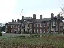
The non-metropolitan county of North Yorkshire is administered by North Yorkshire County Council, a cabinet-style council.[13] The full council of 72 elects a council leader, who in turn appoints up to 9 more councillors to form the executive cabinet. The cabinet is responsible for making decisions in the non-metropolitan county. The county council has its offices in County Hall in Northallerton.
Districts
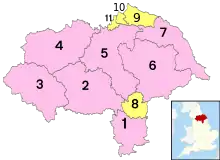
.jpg.webp)
The county is divided into a number of local governing districts of Craven, Hambleton, Harrogate, Richmondshire, Ryedale, Scarborough and Selby.[14]
The Department for Communities and Local Government considered reorganising North Yorkshire County Council's administrative structure by abolishing the seven district councils and the county council to create a North Yorkshire unitary authority. The changes were planned to be implemented no later than 1 April 2009.[15][16] This was rejected on 25 July 2007 so the County Council and District Council structure remained.[17] In 2020 the government announced another structural review with the intention of implementing unitary local governance across all of North Yorkshire with an overarching elected executive mayor.[18]
Unitary
Parts of the county are administered independently of the county council, having their own unitary authorities: the City of York Council, Redcar and Cleveland Borough Council, Middlesbrough Council and Stockton-on-Tees Borough Council. Uniquely for England, the Borough of Stockton-on-Tees is split between two counties: North Yorkshire and County Durham.
Middlesbrough, Redcar and Cleveland and Stockton-on-Tees are also located within the Tees Valley sub-region of North East England. York is a constituent of the Leeds City Region.[19][20]
Economy
The county is affluent and has above average UK house prices. Unemployment is below average for the UK and claimants of Job Seekers Allowance is also very low compared to the rest of the UK at 2.7%.[21]
Agriculture is an important industry, as are mineral extraction and power generation. The county also has prosperous high technology, service and tourism sectors.[22] Tourism is a significant contributor to the economy. A study of visitors between 2013 and 2015 indicated that the Borough of Scarborough, including Filey, Whitby and parts of the North York Moors National Park, received 1.4m trips per year on average.[23] A 2016 report by the National Park however, provides more impressive numbers: the park area gets 7.93 million visitors annually, generating £647 million and supporting 10,900 full-time equivalent jobs.[24]
In 2016, there were 3.8 million visits to the Yorkshire Dales National Park including 0.48 million who stayed at least one night. The parks service estimates that this contributed £252 million to the economy and provided 3,583 full-time equivalent jobs. The wider Yorkshire Dales area received 9.7 million visitors who contributed £644 million to the economy.[25] The North York Moors and Yorkshire Dales are among England’s best known destinations.[26]
The North Yorkshire County Council operates many small tourist information offices in rural areas.[27] Nature or eco-tourism has become an important factor. In addition to hiking, some areas attract tourists with wildlife, although the latter aspect has yet to be fully developed.[28]
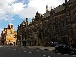
The historic towns of York and Harrogate are the top tourist destinations in the geographic area.[29] York attracts millions of visitors, some of whom may be enticed to continue northward to other areas of North Yorkshire. A 2014 report, based on 2012 data,[30] stated that York alone receives 6.9 million visitors annually; they contribute £564 million to the economy and support over 19,000 jobs.[31] In the 2017 Condé Nast Traveller survey of readers, York rated 12th among The 15 Best Cities in the UK for visitors.[32]
This is a chart of trend of regional gross value added for North Yorkshire at current basic prices with figures in millions of British pounds sterling.[33]
| Year | Regional Gross Value Added[Notes 1] | Agriculture[Notes 2] | Industry[Notes 3] | Services[Notes 4] |
|---|---|---|---|---|
| 1995 | 7,278 | 478 | 2,181 | 4,618 |
| 2000 | 9,570 | 354 | 2,549 | 6,667 |
| 2003 | 11,695 | 390 | 3,025 | 8,281 |
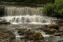 Aysgarth Falls, a popular destination for hikers, can also be reached by a short walk from the main road
 A view of Eston Square from Eston Hills in the town of Eston, Redcar and Cleveland
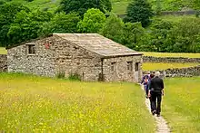 Hikers at a traditional field barn in Muker, North Yorkshire
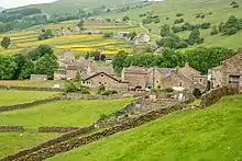 A typical village in the agricultural area of the Yorkshire Dales
 Thirsk is an important town for tourists with accommodation, restaurants and attractions
Education
North Yorkshire LEA has a mostly comprehensive education system with 42 state schools secondary (not including sixth form colleges) and 12 independent schools.
Settlements
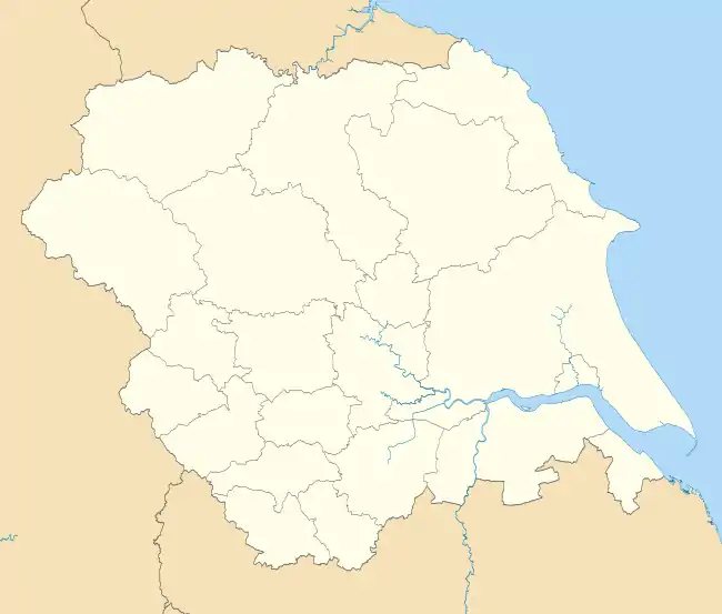
Map
Settlements by urban population
Settlements in italics lie only within one of the four county unitary authorities.
| Rank | Town | Population (2011) |
Borough | Definition | Notes |
|---|---|---|---|---|---|
| 1 | Middlesbrough | 174,700[34] | Middlesbrough | Town | Refers to the settlement based on the Built up area subdivision at the 2011 census. This includes areas outside Middlesbrough Council. |
| 2 | York | 152,841[35] | City of York | City | Refers to the urban settlement based on the built-up area subdivision of York, which excludes any outlying areas within the city of York Council area. The City of York borough covers a wider area than York itself, encompassing surrounding towns and villages. |
| 3 | Harrogate | 73,576[36] | Harrogate | Spa Town | Unparished, but the built-up area subdivision accurately corresponds to the town's boundaries, with no outlying areas. |
| 4 | Scarborough | 38,715 (approximate)[37][38][39][40][41][42] | Scarborough | Town | Town is unparished. There was no population count measuring Scarborough independently at the 2011 census. The built-up area is the closest, but also includes the outlying parishes of Eastfield, Osgodby, Cayton, Newby and Scalby, and part of Seamer. Subtracting the populations of all these parishes from the built-up area count of 61,749, comes to 38,715. |
| 5 | Redcar | 37,073[43] | Redcar and Cleveland | Town | Unparished, but the built-up area subdivision accurately corresponds to the town's boundaries, with no outlying areas. |
| 6 | Thornaby-on-Tees | 24,741[44] | Stockton-on-Tees (south) | Town | Unitary Authority. The built-up area subdivision accurately corresponds to the town's boundaries, with no outlying areas. |
| 7 | Ingleby Barwick | 20,378[45] | Stockton-on-Tees (south) | Civil Parish | |
| 8 | Saltburn, Marske and New Marske | 19,134[46] | Redcar and Cleveland | Civil Parish | |
| 9 | Guisborough | 17,777[47] | Redcar and Cleveland | Civil Parish | |
| 10 | Ripon | 16,702[48] | Harrogate | City | |
| 11 | Knaresborough | 15,441[49] | Harrogate | Civil Parish | |
| 12 | Selby | 14,731[50] | Selby | Civil Parish | |
| 13 | Skipton | 14,623[51] | Craven | Civil Parish | |
| 14 | Whitby | 13,213[52] | Scarborough | Civil Parish | |
| 15 | Skelton and Brotton | 12,848[53] | Redcar and Cleveland | Civil Parish | |
| 16 | Northallerton | 10,655[54] | Hambleton | Civil Parish | County town |
| 17 | Haxby | 8,428[55] | City of York | Civil Parish | |
| 18 | Richmond | 8,413[56] | Richmondshire | Civil Parish | |
| 19 | Yarm-on-Tees | 8,384[57] | Stockton-on-Tees (south) | Civil Parish | |
| 20 | Loftus | 7,988[58] | Redcar and Cleveland | Civil Parish | |
List of settlements
Some settlements of North Yorkshire, italics denote a place in one of the unitary authorities apart from settlements of Middlesbrough:
- Acomb, Alne, Ampleforth, Appleton-le-Moors, Appleton Wiske
- Bedale, Bishopthorpe, Bolton, Boroughbridge, Borrowby (Hambleton), Borrowby (Scarborough), Brompton (Hambleton), Brotton, Buckden
- Castleton, Catterick, Catterick Garrison, Cawood, Clapham, Conistone, Copmanthorpe
- Dalton (Hambleton), Dalton (Richmondshire), Danby Wiske, Drax, Dunnington
- Easby, Easingwold, Egton, Elvington, Eston, Ebberston
- Filey, Folkton, Flixton
- Giggleswick, Gilling East, Gilling West, Glasshouses, Goathland, Grangetown, Grassington, Great Ayton, Grosmont, Guisborough, Ganton, Glaisdale
- Harrogate, Hawes, Haxby, Hebden, Helmsley, High Bentham, Hornton, Hunmanby, Huntington, Hutton Rudby
- Ingleton, Ingleby Arncliffe, Ingleby Barwick, Ingleby Greenhow
- Kettlewell, Kilnsey, Kirkbymoorside, Knaresborough
- Leyburn
- Malham, Malton, Masham, Marske, Middleham, Middlesbrough, Middleton, Ryedale, Muston
- New Marske, Normanby, Northallerton, Norton, North Grimston,
- Osmotherley, Ormesby
- Pateley Bridge, Pickering
- Raskelf, Redcar, Reeth, Riccall, Richmond, Rievaulx, Rillington, Ripon, Robin Hood's Bay, Romanby
- Saltburn, Scagglethorpe, Scampston, Scarborough, Scorton, Selby, Settle, Sherburn, Sheriff Hutton, Shipton, Skelton (Redcar and Cleveland), Skelton (Richmondshire), Skelton (York), Skinningrove, Skipton, Sowerby, Stillington, Stokesley, Streetlam, Sutton, Swinton
- Tadcaster, Teesville, Thirsk, Thornaby
- Whale Hill, Wheldrake, Whitby, Westow, Wintringham
- Yarm, York, Yedingham
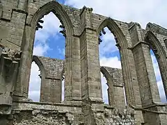
Places of interest
| Key | |
| Abbey/Priory/Cathedral | |
| Accessible open space | |
| Amusement/Theme Park | |
| Castle | |
| Country Park | |
| English Heritage | |
| Forestry Commission | |
| Heritage railway | |
| Historic House | |
| Mosques | |
| Museum (free/not free) | |
| National Trust | |
| Theatre | |
| Zoo | |
Places of interest in italics lie only within the ceremonial county, not the administrative county..
- Ampleforth College
- Beningbrough Hall –


- Bolton Abbey
- Bolton Castle –

- Brimham Rocks –
- Byland Abbey –

- Castle Howard and the Howardian Hills –
- Catterick Garrison
- Cleveland Hills
- Drax
- Duncombe Park – stately home
- Eden Camp Museum –
.svg.png.webp)
- Embsay & Bolton Abbey Steam Railway –

- Eston Nab
- Flamingo Land Theme Park and Zoo –


- Fountains Abbey –
- Gisborough Priory
- Helmsley Castle –
- Ingleborough Cave – show cave
- Kirkham Priory
- Lightwater Valley –
- Lund’s Tower
- Malham Cove
- Middleham Castle –
- Mount Grace Priory –
- North Yorkshire Moors Railway –
- Ormesby Hall – Palladian Mansion
- Richmond Castle –
- Rievaulx Abbey –
- Ripley Castle – Stately home and historic village
- Ripon Cathedral –

- Selby Abbey
- Scarborough Castle –
- Shandy Hall – stately home
- Skipton Castle –
- Stanwick Iron Age Fortifications –
- Studley Royal Park –
- Stump Cross Caverns – show cave
- Tees Transporter Bridge
- Thornborough Henges
- Wainman’s Pinnacle
- Wharram Percy
- Whitby Abbey –
- York Minster –
- Yorkshire Air Museum –
- The Yorkshire Arboretum
News and media
The county is served by BBC North East and Cumbria, and for more southerly parts of the county BBC Yorkshire. Yorkshire Television and Tyne Tees Television are also received in most areas of the county, Settle and the Western part of the Craven area is served by BBC North West and Granada Television. BBC Tees is broadcast to northern parts of the county, whilst BBC Radio York is broadcast more widely. BBC Radio Leeds broadcasts to southern parts of the county.
Transport
Rail
The East Coast Main Line (ECML) bisects the county stopping at Northallerton, Thirsk and York. Passenger services on the ECML within the county are operated by London North Eastern Railway, TransPennine Express and Grand Central. TransPennine Express run services on the York to Scarborough Line and the Northallerton–Eaglescliffe Line (for Middlesbrough) that both branch off the ECML.
Northern operate the remaining lines in the county, including commuter services on the Harrogate Line, Airedale Line and York & Selby Lines, of which the former two are covered by the Metro ticketing area. Remaining branch lines operated by Northern include the Yorkshire Coast Line from Scarborough to Hull, the Hull to York Line via Selby, the Tees Valley Line from Darlington to Saltburn and the Esk Valley Line from Middlesbrough to Whitby. Last but certainly not least, the Settle-Carlisle Line runs through the west of the county, with services again operated by Northern.
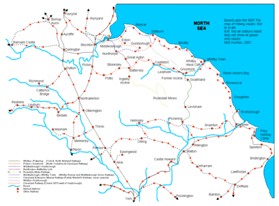
The county suffered badly under the Beeching cuts of the 1960s. Places such as Richmond, Ripon, Tadcaster, Helmsley, Pickering and the Wensleydale communities lost their passenger services. Notable lines closed were the Scarborough and Whitby Railway, Malton and Driffield Railway and the secondary main line between Northallerton and Harrogate via Ripon.
Heritage railways within North Yorkshire include: the North Yorkshire Moors Railway, between Pickering and Grosmont, which opened in 1973; the Derwent Valley Light Railway near York; and the Embsay and Bolton Abbey Steam Railway. The Wensleydale Railway, which started operating in 2003, runs services between Leeming Bar and Redmire along a former freight-only line. The medium-term aim is to operate into Northallerton station on the ECML, once an agreement can be reached with Network Rail. In the longer term, the aim is to reinstate the full line west via Hawes to Garsdale on the Settle-Carlisle line.
York railway station is the largest station in the county, with 11 platforms and is a major tourist attraction in its own right. The station is immediately adjacent to the National Railway Museum.
Road
The main road through the county is the north–south A1(M), which has gradually been upgraded in sections to motorway status since the early 1990s. The only other motorways within the county are the short A66(M) near Darlington and a small stretch of the M62 motorway close to Eggborough.[14] The other nationally maintained trunk routes are the A168/A19, A64, A66 and A174.
Coach and bus
Long-distance coach services are operated by National Express and Megabus. Local bus service operators include Arriva Yorkshire, Harrogate Bus Company, Scarborough & District (East Yorkshire Motor Services), Yorkshire Coastliner, First York and the local Dales & District.
Air
There are no major airports in the county itself, but nearby airports include Teesside International (Darlington), Newcastle, Robin Hood Doncaster Sheffield and Leeds Bradford.
Sport
North Yorkshire is home to several football clubs. Middlesbrough play in the Championship. Harrogate Town play in the EFL League Two. York City who play in the National League North and finished 11th during the 2017-18 National League season. Whitby Town FC have reached the FA Cup first round seven times and have played the likes of Hull City, Wigan and Plymouth Argyle; they currently play in the Evo-Stik Premier League. Other lower league clubs include Marske United, Harrogate Railway Athletic, Northallerton Town, Pickering Town, Scarborough Athletic, Selby Town and Tadcaster Albion.
Rugby union teams in the county include Middlesbrough RUFC, who play their league games in Durham/Northumberland 1. York City Knights, previously known as York F.C., are a rugby league team who play in the Rugby League Championships.
North Yorkshire is home to many racecourses; these include Catterick Bridge, Redcar, Ripon, Thirsk and York. It also has one motor racing circuit, Croft Circuit; the circuit holds meetings of the British Touring Car Championship, British Superbike and Pickup Truck Racing race series and one Motorcycle Racing Circuit at Oliver's Mount, Scarborough.
Yorkshire County Cricket Club play a number of fixtures at North Marine Road, Scarborough.
The ball game Rock-It-Ball was developed in the county.
See also
Notes
- Components may not sum to totals due to rounding
- includes hunting and forestry
- includes energy and construction
- includes financial intermediation services indirectly measured
References
- "New Lord-Lieutenant of North Yorkshire appointed". Gazette & Herald. 13 November 2018. Retrieved 14 November 2018.
- "No. 62943". The London Gazette. 13 March 2020. p. 5161.
- "North Yorkshire County Council : Contact us". www.northyorks.gov.uk. Archived from the original on 18 April 2009. Retrieved 16 May 2009.
- "North Yorkshire population information". North Yorkshire County Council. 30 November 2017. Archived from the original on 15 July 2018. Retrieved 15 July 2018.
- Arnold-Baker, C., Local Government Act 1972, (1973)
- UK Census (2011). "Local Area Report – Middlesbrough Built-up area sub division (1119885093)". Nomis. Office for National Statistics. Retrieved 12 August 2018.
- UK Census (2011). "Local Area Report – York Built-up area sub division (1119883765)". Nomis. Office for National Statistics. Retrieved 12 August 2018.
- "The North Yorkshire (District of York) (Structural and Boundary Changes) Order 1995". OPSI. 10 July 2006. Archived from the original on 10 July 2006.
- "The County Tops". The Relative Hills of Britain. 26 July 2012. Archived from the original on 26 July 2012.
- "Regional mapped climate averages". The Met Office. Archived from the original on 29 December 2010. Retrieved 27 September 2010.
- "UK mapped climate averages". The Met Office. Archived from the original on 30 December 2010. Retrieved 27 September 2010.
- "Temperature of −19C is new Yorkshire record". BBC News Online. BBC. 3 December 2010. Archived from the original on 6 December 2010. Retrieved 4 December 2010.
- "North Yorkshire County Council Constitution". North Yorkshire County Council. Archived from the original on 28 December 2010. Retrieved 10 May 2010.
- "Transport map of shire county divided into districts". North Yorkshire County Council. Archived from the original (PDF) on 7 August 2011. Retrieved 10 October 2008.
- "New council for North Yorkshire". North Yorkshire County Council. Archived from the original on 28 September 2007.
- "Proposals for future unitary structures: Stakeholder consultation" (PDF). Communities and Local Government. Archived (PDF) from the original on 30 October 2008. Retrieved 10 October 2008.
- "County's unitary plan turned down". BBC News. 25 July 2007. Retrieved 3 August 2016.
- "Scrapping North Yorkshire's district councils 'integral' to region's devolution deal, leaders told". The Yorkshire Post. Retrieved 2 August 2020.
- "Scrapping North Yorkshire's district councils 'integral' to region's devolution deal, leaders told". The Yorkshire Post. Retrieved 2 August 2020.
- "List of local authorities and members". North East Assembly. 24 January 2008. Archived from the original on 24 January 2008.
- "York and North Yorkshire – Economic Bulletin". March 2011. Archived from the original on 7 August 2011. Retrieved 21 April 2011.
- "North Yorkshire population information". North Yorkshire County Council. 19 December 2013. Archived from the original on 7 August 2013. Retrieved 17 January 2014.
- "Region's coast 'top tourist draw'". BBC News. 7 June 2016. Archived from the original on 27 September 2018. Retrieved 14 July 2018.
- "Tourism: North York Moors National Park". Archived from the original on 30 June 2017. Retrieved 14 July 2018.
- "Trends in tourism in the Yorkshire Dales 2010 to 2016" (PDF). Archived from the original (PDF) on 14 July 2018. Retrieved 14 July 2018.
- "Growing the Visitor Economy of North Yorkshire's Protected Landscapes" (PDF). Archived (PDF) from the original on 15 July 2018. Retrieved 14 July 2018.
- "North Yorkshire tourist information". North Yorkshire County Council. 9 November 2017. Archived from the original on 15 July 2018. Retrieved 14 July 2018.
- "North Yorkshire nature tourism can boost the economy by millions of pounds, report claims". The Yorkshire Post. Archived from the original on 15 July 2018. Retrieved 14 July 2018.
- "Tourism and Travel – Leisure, Sport & Tourism – Yorkshire Employment and Training Information". Yorkshire Graduates. Archived from the original on 15 July 2018. Retrieved 14 July 2018.
- "Tourists spend more than £600m". BBC. 11 February 2014. Archived from the original on 12 July 2018. Retrieved 27 June 2018.
- "Report" (PDF). VisitYork. Archived (PDF) from the original on 27 June 2018. Retrieved 27 June 2018.
- Traveller, Condé Nast. "The best cities in the UK". www.cntraveller.com. Archived from the original on 27 June 2018. Retrieved 27 June 2018.
- "Regional Gross Value Added" (PDF). Office for National Statistics. 21 December 2005. pp. 240–253. Archived from the original (PDF) on 1 December 2007. Retrieved 6 October 2008.
- UK Census (2011). "Local Area Report – Middlesbrough Built-up area sub dividion (E35001385)". Nomis. Office for National Statistics. Retrieved 23 February 2020.
- UK Census (2011). "Local Area Report – York Built-up area sub division (E35000051)". Nomis. Office for National Statistics. Retrieved 23 February 2020.
- UK Census (2011). "Local Area Report – Harrogate Built-up area sub division (E35000975)". Nomis. Office for National Statistics. Retrieved 23 February 2020.
- UK Census (2011). "Local Area Report – Scarborough Built-up area (E34004408)". Nomis. Office for National Statistics. Retrieved 23 February 2020.
- UK Census (2011). "Local Area Report – Eastfield Parish (E04007709)". Nomis. Office for National Statistics. Retrieved 23 February 2020.
- UK Census (2011). "Local Area Report – Osgodby Parish (E04007694)". Nomis. Office for National Statistics. Retrieved 23 February 2020.
- UK Census (2011). "Local Area Report – Cayton Parish (E04007663)". Nomis. Office for National Statistics. Retrieved 23 February 2020.
- UK Census (2011). "Local Area Report – Newby and Scalby Parish (E04007691)". Nomis. Office for National Statistics. Retrieved 23 February 2020.
- UK Census (2011). "Local Area Report – Seamer Parish (E04007697)". Nomis. Office for National Statistics. Retrieved 23 February 2020.
- UK Census (2011). "Local Area Report – Redcar Built-up area sub division (E35000002)". Nomis. Office for National Statistics. Retrieved 23 February 2020.
- UK Census (2011). "Local Area Report – Thornaby-on-Tees Built-up area sub division) (E35001481)". Nomis. Office for National Statistics. Retrieved 23 February 2020.
- UK Census (2011). "Local Area Report – Ingleby Barwick Parish (E04000275)". Nomis. Office for National Statistics. Retrieved 23 February 2020.
- UK Census (2011). "Local Area Report – Saltburn, Marske and New Marske Parish (E04000266)". Nomis. Office for National Statistics. Retrieved 23 February 2020.
- UK Census (2011). "Local Area Report – Guisborough Parish (E04000263)". Nomis. Office for National Statistics. Retrieved 23 February 2020.
- UK Census (2011). "Local Area Report – Ripon Parish (E04007409)". Nomis. Office for National Statistics. Retrieved 23 February 2020.
- UK Census (2011). "Local Area Report – Knaresborough Parish (E04007372)". Nomis. Office for National Statistics. Retrieved 23 February 2020.
- UK Census (2011). "Local Area Report – Selby Parish (E04007765)". Nomis. Office for National Statistics. Retrieved 23 February 2020.
- UK Census (2011). "Local Area Report – Skipton Parish (E04007117)". Nomis. Office for National Statistics. Retrieved 23 February 2020.
- UK Census (2011). "Local Area Report – Whitby Parish (E04007706)". Nomis. Office for National Statistics. Retrieved 23 February 2020.
- UK Census (2011). "Local Area Report – Skelton and Brotton Parish (E04000267)". Nomis. Office for National Statistics. Retrieved 23 February 2020.
- UK Census (2011). "Local Area Report – Northallerton Parish (E04007234)". Nomis. Office for National Statistics. Retrieved 23 February 2020.
- UK Census (2011). "Local Area Report – Haxby Parish (E04000603)". Nomis. Office for National Statistics. Retrieved 23 February 2020.
- UK Census (2011). "Local Area Report – Richmond Parish (E04007520)". Nomis. Office for National Statistics. Retrieved 23 February 2020.
- UK Census (2011). "Local Area Report – Yarm Parish (E04012074)". Nomis. Office for National Statistics. Retrieved 23 February 2020.
- UK Census (2011). "Local Area Report – Loftus Parish (E04000265)". Nomis. Office for National Statistics. Retrieved 23 February 2020.
External links
| Look up North Yorkshire in Wiktionary, the free dictionary. |
| Wikimedia Commons has media related to North Yorkshire. |
| Wikivoyage has a travel guide for North Yorkshire. |
- North Yorkshire County Council
- BBC North Yorkshire – North Yorkshire features, videos and pictures from the BBC
- Yorkshire Dales Rivers Trust
- North Yorkshire at Curlie
- Images of North Yorkshire at the English Heritage Archive
- Yorkshire Coast Radio
| Ceremonial counties | |
|---|---|
| Historic divisions | |
| Geography | |
| History | |
| Culture and heritage | |
| |
| Authority control |
|---|