IJsselstein
IJsselstein (Dutch pronunciation: [ˈɛisəlstɛin] (![]() listen)) is a municipality and a city in the Netherlands, in the province of Utrecht. IJsselstein received city rights in 1331. IJsselstein owes its name to the river Hollandse IJssel which flows through the city. It is a major commuting suburb for the Utrecht area, along with neighbouring towns Houten and Nieuwegein (in part due to the Sneltram light rail line serving the area). It's surrounded by the municipalities of Utrecht, Montfoort, Lopik, Vijfheerenlanden and Nieuwegein.
listen)) is a municipality and a city in the Netherlands, in the province of Utrecht. IJsselstein received city rights in 1331. IJsselstein owes its name to the river Hollandse IJssel which flows through the city. It is a major commuting suburb for the Utrecht area, along with neighbouring towns Houten and Nieuwegein (in part due to the Sneltram light rail line serving the area). It's surrounded by the municipalities of Utrecht, Montfoort, Lopik, Vijfheerenlanden and Nieuwegein.
IJsselstein | |
|---|---|
City and Municipality | |
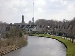 Hollandse IJssel through IJsselstein with church and Gerbrandy Tower in background | |
 Flag  Coat of arms | |
.svg.png.webp) Location in Utrecht | |
| Coordinates: 52°1′N 5°2′E | |
| Country | Netherlands |
| Province | Utrecht |
| Government | |
| • Body | Municipal council |
| • Mayor | Patrick van Domburg (VVD) |
| Area | |
| • Total | 21.68 km2 (8.37 sq mi) |
| • Land | 21.07 km2 (8.14 sq mi) |
| • Water | 0.61 km2 (0.24 sq mi) |
| Elevation | 1 m (3 ft) |
| Population (January 2019)[4] | |
| • Total | 34,160 |
| • Density | 1,621/km2 (4,200/sq mi) |
| Demonym(s) | IJsselsteiner(s) |
| Time zone | UTC+1 (CET) |
| • Summer (DST) | UTC+2 (CEST) |
| Postcode | 3400–3404 |
| Area code | 030 |
| Website | www |
Sights
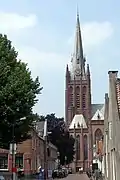
The city has an old town, surrounded by a small canal. A castle stood in IJsselstein from 1300 to 1888; the tower survived. The city has two large churches, both named after St. Nicholas: the Dutch Reformed Nicolaas church, founded in 1310, and a Roman Catholic one. Inside the Protestant church there are two mausoleums; one of the family of Gijsbrecht van Amstel (1350) and another one of Aleida van Culemborg (1475). The catholic basilica of St. Nicolaas dates from 1887 and is neo-gothic. It was given the title of 'Basilica Minor' by Pope Paul VI in 1972.
A 366.8 metres high television mast, called the Gerbrandy Tower, is located in IJsselstein. The tower is commonly, and erroneously, referred to as Zendmast Lopik, after the nearby village of Lopik.
Topography
 Dutch Topographic map of the municipality of IJsselstein, June 2015
 1649 map of IJsselstein in Willem and Joan Blaeu's "Toonneel der Steden"
Notable people

- Arnold, Lord of IJsselstein (1304–1363) the second Lord of IJsselstein and Stoutenburg
- Maximiliaan of Egmont (1509–1548) was Count of Buren and Leerdam, and Stadtholder of Friesland 1540 to 1548
- Patrick van den Brink (born 1967) a Dutch politician and former civil servant; Mayor of IJsselstein since 2007
- Marijke van Beukering-Huijbregts (born 1971) a Dutch politician
- Michel Vorm (born 1983) a Dutch football goalkeeper with English club Tottenham Hotspur F.C.
Gallery
 Catholic basilica
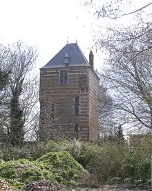 Tower of the former castle
 Achtersloot 120, IJsselstein
 Protestant church
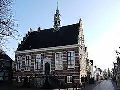 HistorischStadhuis, IJsselstein
References
- "Samenstelling" [Members] (in Dutch). Gemeente IJsselstein. Archived from the original on 8 April 2014. Retrieved 7 April 2014.
- "Kerncijfers wijken en buurten 2020" [Key figures for neighbourhoods 2020]. StatLine (in Dutch). CBS. 24 July 2020. Retrieved 19 September 2020.
- "Postcodetool for 3401BK". Actueel Hoogtebestand Nederland (in Dutch). Het Waterschapshuis. Archived from the original on 21 September 2013. Retrieved 7 April 2014.
- "Bevolkingsontwikkeling; regio per maand" [Population growth; regions per month]. CBS Statline (in Dutch). CBS. 1 January 2019. Retrieved 1 January 2019.
External links
 Media related to IJsselstein at Wikimedia Commons
- Official website
Places adjacent to IJsselstein | ||||||||||
|---|---|---|---|---|---|---|---|---|---|---|
| ||||||||||
Municipalities of Utrecht | ||
|---|---|---|
 | ||
| ||
| Authority control |
|---|
