Montfoort
Montfoort (Dutch pronunciation: [ˈmɔntfoːrt] (![]() listen)) is a municipality and a city in the Netherlands, in the province of Utrecht. Montfoort received city rights in 1329.
listen)) is a municipality and a city in the Netherlands, in the province of Utrecht. Montfoort received city rights in 1329.
Montfoort | |
|---|---|
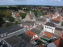 Montfoort city centre | |
 Flag  Coat of arms | |
.svg.png.webp) Location in Utrecht | |
| Coordinates: 52°3′N 4°57′E | |
| Country | Netherlands |
| Province | Utrecht |
| Government | |
| • Body | Municipal council |
| • Mayor | Petra van Hartskamp (VVD) |
| Area | |
| • Total | 38.20 km2 (14.75 sq mi) |
| • Land | 37.57 km2 (14.51 sq mi) |
| • Water | 0.63 km2 (0.24 sq mi) |
| Elevation | 2 m (7 ft) |
| Population (January 2019)[4] | |
| • Total | 13,996 |
| • Density | 373/km2 (970/sq mi) |
| Time zone | UTC+1 (CET) |
| • Summer (DST) | UTC+2 (CEST) |
| Postcode | 3417, 3460–3461 |
| Area code | 0348 |
| Website | www |
Population centres
The municipality of Montfoort consists of the following cities, towns, villages and/or districts:
- Achthoven
- Achthoven-Oost
- Blokland
- Cattenbroek
- Heeswijk
- Knollemanshoek
- Linschoten
- Mastwijk
- Montfoort
- Willeskop
Topography

Dutch topographic map of the municipality of Montfoort, June 2015

Notable people
- Jan III van Montfoort (ca.1448 – 1522) a leader of the Hook Party in the Bishopric of Utrecht
- Anthonie Blocklandt van Montfoort (1533 or 1534 - 1583) a Dutch painter
- Isbrand van Diemerbroeck (1609–1674) a Dutch physician, anatomist and professor
- Matthew Maty (1718–1776) a physician and writer, secretary of the Royal Society and librarian of the British Museum[5]
- Mark van Eldik (born 1967) a Dutch rally driver
Gallery
 Old town hall of Montfoort
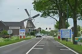 Montfoort Utrecht with the still working flourmill
 De Hoogstraat de oudste en belangrijkste straat van Montfoort
 View to Montfoort
 Lock: schutsluis Montfoortse Vaart
References
- "burgemeester E.L. (Bert) Jansen" [mayor E.L. (Bert) Jansen] (in Dutch). Gemeente Montfoort. Archived from the original on 8 April 2014. Retrieved 7 April 2014.
- "Kerncijfers wijken en buurten 2020" [Key figures for neighbourhoods 2020]. StatLine (in Dutch). CBS. 24 July 2020. Retrieved 19 September 2020.
- "Postcodetool for 3417JG". Actueel Hoogtebestand Nederland (in Dutch). Het Waterschapshuis. Retrieved 7 April 2014.
- "Bevolkingsontwikkeling; regio per maand" [Population growth; regions per month]. CBS Statline (in Dutch). CBS. 1 January 2019. Retrieved 1 January 2019.
- Dictionary of National Biography, 1885-1900, Volume 37, Maty, Matthew retrieved 20 December 2019
External links
 Media related to Montfoort at Wikimedia Commons
- Official website
Places adjacent to Montfoort | ||||||||||
|---|---|---|---|---|---|---|---|---|---|---|
| ||||||||||
Municipalities of Utrecht | ||
|---|---|---|
 | ||
| ||
| Authority control |
|---|
This article is issued from Wikipedia. The text is licensed under Creative Commons - Attribution - Sharealike. Additional terms may apply for the media files.