Igaliku
Igaliku is a settlement in the Kujalleq municipality in southern Greenland. The town was founded as Igaliko in 1783 by the trader and colonial administrator Anders Olsen and Greenlandic wife Tuperna. In 2020, Igaliku had 21 inhabitants.[2]
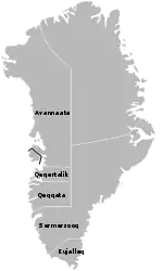
Igaliku
Garðar, Igaliko | |
|---|---|
 | |
 Igaliku Location within Greenland | |
| Coordinates: 60°59′16″N 45°25′15″W | |
| State | |
| Constituent country | |
| Municipality | |
| Founded | 1783 |
| Government | |
| • Mayor | Klaus Egede |
| Population (2020) | |
| • Total | 21 |
| Time zone | UTC−03:00 |
| Postal code | 3921 Narsaq |
Geography
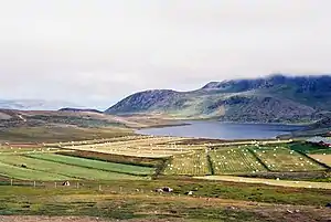
Igaliku is located southeast of Narsarsuaq, on a peninsula jutting off the mainland of Greenland near the eastern shore of upper Tunulliarfik Fjord.[3] Access to Igaliku from Narsarsauq is cheaper and easier by landing at the small harbor of Itilleq and then crossing the isthmus 4 km (2.5 mi).[4]
Landmarks and sights
Igaliku is best known for the ruins of Garðar, once the religious heart of 12th-century Norse Greenland.[5] The area was at the very heart of the Eastern Settlement and has been extensively archaeologically excavated since the 1830s. There are several historical graves in the area, although most have not presently been identified. The nearby area was documented by New York fine art photographer, Steve Giovinco, as part of a grant from the Scandinavian-American Foundation.
Infrastructure
The settlement has a general store, a church including the congregation building, and a school, Atuarfik Igaliku (Greenlandic for "the school of Igaliku"). There is only one road into the village (called King's Road), which connects Igaliku to a small dock at the farming settlement, Itilleq.
Population
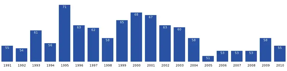
The population of Igaliku has been stable in the last two decades.[6]
Climate
Igaliku has a tundra climate (ET) with cool summers and cold winters.
| Climate data for Igaliku (1982-2012) | |||||||||||||
|---|---|---|---|---|---|---|---|---|---|---|---|---|---|
| Month | Jan | Feb | Mar | Apr | May | Jun | Jul | Aug | Sep | Oct | Nov | Dec | Year |
| Average high °C (°F) | −2.5 (27.5) |
−1.6 (29.1) |
−0.9 (30.4) |
3.3 (37.9) |
8.5 (47.3) |
11.8 (53.2) |
13.7 (56.7) |
12.9 (55.2) |
8.8 (47.8) |
3.8 (38.8) |
0.5 (32.9) |
−1.9 (28.6) |
4.7 (40.4) |
| Daily mean °C (°F) | −6.4 (20.5) |
−5.5 (22.1) |
−4.8 (23.4) |
−0.4 (31.3) |
4.6 (40.3) |
7.6 (45.7) |
9.5 (49.1) |
8.9 (48.0) |
5.4 (41.7) |
0.8 (33.4) |
−2.8 (27.0) |
−5.6 (21.9) |
0.9 (33.7) |
| Average low °C (°F) | −10.2 (13.6) |
−9.4 (15.1) |
−8.6 (16.5) |
−4.1 (24.6) |
0.8 (33.4) |
3.5 (38.3) |
5.4 (41.7) |
4.9 (40.8) |
2 (36) |
−2.2 (28.0) |
−6.1 (21.0) |
−9.3 (15.3) |
−2.8 (27.0) |
| Average precipitation mm (inches) | 58 (2.3) |
50 (2.0) |
53 (2.1) |
54 (2.1) |
50 (2.0) |
67 (2.6) |
79 (3.1) |
84 (3.3) |
94 (3.7) |
72 (2.8) |
81 (3.2) |
73 (2.9) |
815 (32.1) |
| Source: Time and Date[7] | |||||||||||||
References
- "Sermitsiaq, 2008/07/18" (in Danish). Archived from the original on August 2, 2008. Retrieved April 17, 2011.
- "Population by Localities". Statistical Greenland. Retrieved 7 April 2020.
- Ivittuut/Narsarsuaq/Qaqortoq, Saga Map, Tage Schjøtt, 1992
- "Metal Traveller in Igaliku". Metaltraveller. Retrieved 2011-09-09.
- O'Carroll, Etain (2005). Greenland and the Arctic. Lonely Planet. p. 108. ISBN 1-74059-095-3.
- "Statistics Greenland" (in Danish). Archived from the original on August 12, 2011. Retrieved April 17, 2011.
- "IGALIKU CLIMATE". Retrieved April 13, 2020.