Iide Mountains
The Iide Mountains (飯豊連峰, Iide-renpō) or Iide Mountain district (飯豊山地, Iide-sanchi) is a mountain range that spans the Fukushima, Niigata and Yamagata prefectures in Japan. Its highest peak is Mount Dainichi (大日岳, Dainichi-dake) at 2,128m,[1] and the main peak of the range is Mount Iide at 2,105m above sea level.[1] The range contains a number of peaks higher than 2000m and is a part of the Bandai-Asahi National Park.[2]
| Iide Mountains | |
|---|---|
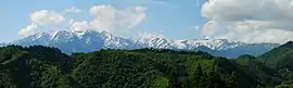 Iide Mountain Range seen from Aizu, Fukushima | |
| Highest point | |
| Peak | Mount Dainichi, Kiso District |
| Elevation | 2,128 m (6,982 ft) |
| Coordinates | 37°49′59″N 139°39′38″E |
| Naming | |
| Native name | 飯豊連峰 |
| Geography | |
| Country | Japan |
| Prefectures | Niigata, Yamagata and Fukushima |
Peaks
Below are some of the peaks of the Iide Mountains:[3]
- Mt. Dainichi (大日岳, Dainichi-dake) (2,128m)
- Mt. Iide (飯豊山, Iide-san) (2,105m)
- Mt. Kitamata (北股岳, Kitamata-dake) (2,024m)
- Mt. Eboshi (烏帽子岳, Eboshi-dake) (2,017m)
- Mt. Onishi (御西岳, Onishi-dake) (2,012m)
- Mt. Tanemaki (種蒔山, Tanemaki-yama) (1,791m)
- Mt. Mikuni (三国岳, Mikuni-dake) (1,664m)
Notes
- "Archived copy" 山都町の紹介. Kitakata official webpage (in Japanese). Kitakata City, Fukushima. Archived from the original on August 19, 2011. Retrieved August 17, 2011.CS1 maint: archived copy as title (link)
- 磐梯朝日国立公園. 国立公園 - National parks of Japan (in Japanese). Ministry of the Environment. Retrieved August 17, 2011.
- "Archived copy" 飯豊山の概要 > 飯豊山とは.... Kitakata Sightseeing Association (in Japanese). Kitakata City. Archived from the original on March 30, 2012. Retrieved August 17, 2011.CS1 maint: archived copy as title (link)
This article is issued from Wikipedia. The text is licensed under Creative Commons - Attribution - Sharealike. Additional terms may apply for the media files.