Ikaria (regional unit)
Ikaria (Greek: Περιφερειακή ενότητα Ικαρίας) is one of the regional units of Greece. It is part of the region of North Aegean. The regional unit covers the island of Ikaria and the small archipelago Fournoi Korseon, in the Aegean Sea.
Ikaria
Περιφερειακή ενότητα Ικαρίας | |
|---|---|
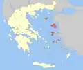
 Municipalities of Ikaria and Samos | |
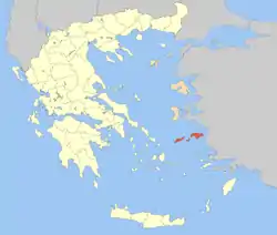 Samos and Ikaria within Greece | |
| Coordinates: 37°40′N 26°20′E | |
| Country | Greece |
| Region | North Aegean |
| Area | |
| • Total | 300.6 km2 (116.1 sq mi) |
| Population (2011) | |
| • Total | 9,882 |
| • Density | 33/km2 (85/sq mi) |
| Time zone | UTC+2 |
| • Summer (DST) | UTC+3 (EEST) |
Administration
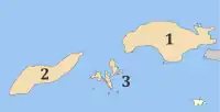
As a part of the 2011 Kallikratis government reform, the regional unit Ikaria was created out of part of the former Samos Prefecture. It is subdivided into 2 municipalities. These are (number as in the map in the infobox):[1]
- Ikaria (2)
- Fournoi Korseon (3)
| New municipality | Old municipalities | Seat |
|---|---|---|
| Ikaria | Agios Kirykos | Agios Kirykos |
| Evdilos | ||
| Raches | ||
| Fournoi Korseon | Fournoi Korseon | Fournoi |
References
- "Kallikratis reform law text" (PDF).
- "Detailed census results 1991" (PDF). Archived (PDF) from the original on 2016-03-03. (39 MB) (in Greek and French)
This article is issued from Wikipedia. The text is licensed under Creative Commons - Attribution - Sharealike. Additional terms may apply for the media files.