Illinois Route 56
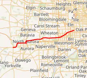
Illinois Route 56 (IL 56) is a 32.52-mile-long (52.34 km) east–west state road in northern and northeastern Illinois. It runs from the interchange of Illinois Route 47 at U.S. Route 30 (US 30) in Sugar Grove east to US 12/US 20/US 45 (Mannheim Road) by Bellwood.[1]
| ||||
|---|---|---|---|---|
| Butterfield Road Lincolnway Street Bill Hewitt Memorial Highway | ||||
IL 56 highlighted in red | ||||
| Route information | ||||
| Maintained by IDOT and ISTHA | ||||
| Length | 32.52 mi[1] (52.34 km) | |||
| Existed | 1924[2]–present | |||
| Major junctions | ||||
| West end | ||||
| East end | ||||
| Location | ||||
| Counties | Kane, DuPage, Cook | |||
| Highway system | ||||
| ||||

Route description
Illinois 56 parallels Interstate 88 (Ronald Reagan Memorial Tollway) for its entire length and merges with it at Illinois Route 31, making it the only state road to be marked as a toll road—only Illinois Route 190 and Illinois Route 5 have ever had this distinction. Travelling eastbound, it begins at US 30 in Sugar Grove just west of Orchard Road and then runs with the I-88 tollway until intersecting Illinois Route 31. The route travels north with IL 31 briefly, then crosses over the Fox River. From there, the route heads in a northeasterly direction, paralleling I-88 to the north. The route ends at US 12/US 20/US 45.
Route 56 is called Butterfield Road for its entire length east of Illinois Route 25 until it meets its end as Washington Boulevard in Bellwood. It serves the Chicago suburbs of Aurora, Downers Grove, Elmhurst, Oak Brook, Wheaton, and other communities, as well as the College of DuPage, Oakbrook Center shopping mall, and farther out, the Fermilab in Batavia. Butterfield Road is a major arterial road within the Illinois Technology and Research Corridor. Illinois 194 was also a toll road.
History
SBI Route 56 was the current Illinois 56 from Oak Brook to Bellwood on Butterfield Road.[2] On April 2, 1965, the Illinois State Division of Highways announced that the IL 56 designation over IL 55 west of 22nd Street, which was duplicated by the designation of Interstate 55.[3] The rest of IL 55 was removed east to Ogden Avenue via Cermak Road.[4] In 1972, the eastern end was truncated to its current location.[5] The western end of Illinois 56 is part of the old alignment of the old East–West Tollway.[2]
Major intersections
| County | Location | mi[6] | km | Destinations | Notes |
|---|---|---|---|---|---|
| Kane | Sugar Grove | 0.0 | 0.0 | Western terminus; interchange | |
| 1.5 | 2.4 | Galena Boulevard | Interchange | ||
| 3.9 | 6.3 | West end of I-88/IL 110 overlap; westbound exit and eastbound exit; I-88 exit 113 | |||
| Aurora–North Aurora city line | 4.7 | 7.6 | Toll on eastbound exit westbound entrance; Exit 114 in both directions; was Exit 115 | ||
| North Aurora | 7.4 | 11.9 | East end of I-88/IL 110 overlap; West end of IL 31 overlap; I-88 exit 117 | ||
| 8.3 | 13.4 | East end of IL 31/Lincoln Highway overlap | |||
| 8.6 | 13.8 | ||||
| DuPage | Warrenville | 14.8 | 23.8 | ||
| Glen Ellyn | 22.7 | 36.5 | |||
| Downers Grove | 24.0 | 38.6 | I-355 exit 22 | ||
| 25.0 | 40.2 | Interchange; northern terminus of CR 9 | |||
| Oakbrook Terrace | 28.1 | 45.2 | Interchange; westbound access to access to IL 83 via IL 38 west; no westbound entrance from IL 83 north; no eastbound access to IL 83 south | ||
| Oakbrook Terrace–Elmhurst line | 28.4 | 45.7 | Interchange; eastbound access to IL 38 via IL 83 north; no westbound access to IL 38 east | ||
| Cook | Bellwood | 32.52 | 52.34 | Eastern terminus | |
1.000 mi = 1.609 km; 1.000 km = 0.621 mi
| |||||
See also
References
- Illinois Technology Transfer Center (2006). "T2 GIS Data". Retrieved 2007-11-08.
- Carlson, Rick. Illinois State Highways Page: Routes 41 through 60. Last updated April 15, 2005. Retrieved March 31, 2006.
- "Change State Route 55 Designation to Route 56". The Chicago Tribune. April 3, 1965. p. S2.
- Illinois Division of Highways; Rand McNally (1965). Illinois Official Highway Map (Map). [1:757,500]. Springfield: Illinois Division of Highways – via Illinois Digital Archives.
- Illinois Department of Transportation (1972). Illinois Official Highway Map (Map). [1:772,500]. Springfield: Illinois Department of Transportation – via Illinois Digital Archives.
- Google (February 19, 2017). "Overview Map of IL 56" (Map). Google Maps. Google. Retrieved February 19, 2017.