Chicago–Kansas City Expressway
The Chicago–Kansas City Expressway is a highway that runs between Chicago, Illinois, and Claycomo, Missouri. The road is known as Route 110 in Missouri and Illinois Route 110 (IL 110) in Illinois. IL 110 was created through legislation on May 27, 2010, as the designated route for the Illinois portion of the Chicago–Kansas City Expressway.
| Route 110 | |||||||||
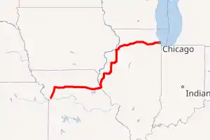
Chicago–Kansas City Expressway highlighted in red | |||||||||
| Route information | |||||||||
| Maintained by IDOT and MoDOT | |||||||||
| Length | 527.6 mi[1][2] (849.1 km) Missouri: 199.561 mi (321.162 km) Illinois: 328 mi (528 km) | ||||||||
| Existed | May 27, 2010–present | ||||||||
| Component highways | |||||||||
| Major junctions | |||||||||
| West end | |||||||||
| |||||||||
| East end | |||||||||
| Highway system | |||||||||
| |||||||||
Route description
Missouri
The Expressway starts in downtown Claycomo on I-35 and leaves the city in a northeast direction. In Cameron, the route turns east on US 36 and crosses the state via Chillicothe and Macon. East of Hannibal, the route continues east on I-72 through Hannibal and across the Mississippi River.[3]
US 36 and I-35 in Missouri are now in the process to have the comprehensive sign package similar to Illinois along the Chicago–Kansas City Expressway, including the Route 110 designation and the "CKC" logo on every route marker between Hannibal and Kansas City.[4]
Illinois
IL 110 crosses into Illinois from the Mark Twain Memorial Bridge east of Hannibal. It follows Interstate 72 (I-72) east to I-172, then runs north with I-172 to IL 336 around the city of Quincy. Both routes run north to Carthage, where IL 110 and IL 336 join with US 136. All three routes run east to Macomb, where IL 110 then continues north with US 67 to Monmouth. There is a two-mile (3.2 km) stretch of the route in Good Hope, where it is reduced from a four-lane divided highway to a three-lane undivided street with a center turn lane.
At Monmouth, IL 110 joins US 34 and runs east to I-74. IL 110 then joins I-74 and runs north to near the Quad Cities, joining with I-80 before joining I-88 eastbound. The two highways continue east to I-88's eastern terminus in Hillside, where IL 110 continues on I-290, terminating at the Circle Interchange near the Chicago Loop.
History
Cannon Ball Route
The Cannon Ball Route was a historic auto trail that ran from Hannibal, Missouri east-northeast to Chicago, Illinois.[5] The route was included in the 1917 Map of Marked Routes provided by the Illinois State Highway Department, a precursor to the modern-day Illinois Department of Transportation.
This highway routing closely parallels the Hannibal-Quincy to Chicago branch of the Chicago, Burlington & Quincy Railroad. This route stayed west and north of the Illinois River, so this route never had to cross the limited number of Illinois River bridges in 1917.
Southern Illinois
IL 110 was the designation for what is present-day IL 15 from St. Libory, Illinois to just south of Addieville, where it meets up with IL 160. During the World War II years, IL 15 was part of what is now IL 160, and the section from St. Libory to Addieville was IL 110. The number was dropped in favor of US 460; the present IL 15 and IL 160 routings came in the mid-1960s.
Raven Road in Washington County is a stub of the former IL 15, and that intersection was the eastern terminus of IL 110.
Current route
Efforts to construct a direct route from Chicago to Kansas City have been in the planning stages since its exclusion from the Interstate Highway System in the 1950s. These efforts have been led by the Tri-State Development Summit, an economic development group for western Illinois, southeastern Iowa, and northern Missouri.[6][7] The proposed highway took different forms over time: a 1989 study found that a full, limited-access tollway running from Kansas Turnpike at Kansas City to the Indiana Toll Road at Gary or Tri-State Tollway near the Joliet area would cost $2–$2.5 billion, if funded entirely by private investors.[8]
In a joint resolution between the Illinois House and Senate in late May 2010,[9] an expressway project connecting Chicago-to-Kansas City was named Illinois Route 110 (IL 110). The path, 532 miles (856 km) in total,[10] follows parts of the existing IL 336, I-88, I-172, I-72, I-74, US 136, US 67 and connect the cities of Quincy, Macomb, Galesburg, a number of communities of the Chicago metropolitan area, including Chicago itself on I-290.[6][7][11]
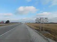
In 2010, signs were posted with the "CKC" banner above the IL 110 sign. The Illinois Department of Transportation erected 470 IL 110 (CKC) signs at a cost of $94,000.[3][12]
Junction list
| State | County | Location[13] | mi[2] | km | Exit | Destinations | Notes |
|---|---|---|---|---|---|---|---|
| Missouri | Clay | Claycomo | 0.00 | 0.00 | Western terminus of Route 110/CKC Expwy.; western end of I-35 overlap; exit 12A on I-35; exit 52B on I-435 | ||
| Pleasant Valley | 1.2 | 1.9 | 13 | Southern end of US 69 overlap; exit numbers follow I-35; signed as exit 14 southbound | |||
| Liberty | 3.4 | 5.5 | 16 | ||||
| 4.9 | 7.9 | 17 | |||||
| 7.0 | 11.3 | 20 | Northern end of US 69 overlap | ||||
| Kearney | 13.3 | 21.4 | 26 | ||||
| Clinton | Holt | 20.2 | 32.5 | 33 | |||
| | 27.1 | 43.6 | 40 | ||||
| | 35.3 | 56.8 | 48 | ||||
| Cameron | 39.8 | 64.1 | 52 | ||||
| DeKalb | 41.4 | 66.6 | 54 | Northern end of I-35 overlap; western end of US 36 overlap; exit 54 on I-35 | |||
| Caldwell | Hamilton Township | 51.1 | 82.2 | ||||
| Hamilton | 53.2 | 85.6 | Interchange | ||||
| Livingston | Chillicothe | 78.3 | 126.0 | Interchange | |||
| 79.0 | 127.1 | ||||||
| Linn | Parson Creek Township | 91.6 | 147.4 | Western end of Route 139 overlap | |||
| Jefferson Township | 96.5 | 155.3 | |||||
| Laclede | 98.4 | 158.4 | Eastern end of Route 139 overlap; western end of Route 5 overlap | ||||
| Brookfield | 102 | 164 | |||||
| 104 | 167 | ||||||
| Marceline–Bucklin township line | 111 | 179 | Interchange; eastern end of Route 5 overlap | ||||
| Bucklin Township | 114 | 183 | Western end of Route 129 overlap | ||||
| Macon | Lingo Township | 119 | 192 | Eastern end of Route 129 overlap | |||
| 121 | 195 | Interchange | |||||
| Callao Township | 128 | 206 | Interchange | ||||
| Bevier Township | 131 | 211 | Interchange | ||||
| Hudson Township | 135 | 217 | Long Branch Lake Road | Interchange | |||
| Macon | 137 | 220 | Interchange | ||||
| Hudson Township | 139 | 224 | |||||
| Shelby | Clarence | 148 | 238 | Interchange | |||
| 149 | 240 | ||||||
| Shelbina | 159 | 256 | |||||
| 160 | 260 | Interchange | |||||
| 161 | 259 | ||||||
| Marion | Monroe City | 177 | 285 | ||||
| Ralls | 179 | 288 | Interchange, western end of US 24 overlap | ||||
| Marion | Miller Township | 190 | 310 | Interchange, eastern end of US 24 overlap; western end of freeway section | |||
| Hannibal | 194 | 312 | Shinn Lane | ||||
| 196 | 315 | Veterans Road | |||||
| 197 | 317 | Western end of I-72 overlap | |||||
| 198 | 319 | 157 | Exit numbers follow I-72 | ||||
| Mississippi River | 199.561 0.00 | 321.162 0.00 | Mark Twain Memorial Bridge | ||||
| Illinois | Pike | Levee Township | 1.2 | 1.9 | 1 | ||
| 4.3 | 6.9 | Eastern end of I-72/US 36 overlap; southern end of I-172 overlap; exit 4 on I-72; exit 0 on I-172 | |||||
| Adams | Fall Creek Township | 7.5 | 12.1 | 2 | Exit numbers follow I-172 | ||
| Melrose Township | 14.9 | 24.0 | 10 | ||||
| Quincy | 18.8 | 30.3 | 14 | Serves Quincy Airport | |||
| Ellington Township | 20.2 | 32.5 | 15 | Columbus Road, Wismann Lane | |||
| 24.0 | 38.6 | 19 | Northern end of I-172 overlap; southern end of IL 336 overlap; northern end freeway section | ||||
| | 30.6 | 49.2 | Interchange; southern end of IL 61 overlap | ||||
| | 35.0 | 56.3 | Northern end of IL 61 overlap | ||||
| Hancock | | 45.4 | 73.1 | Southern end of IL 94 overlap | |||
| | 56.5 | 90.9 | Northern end of IL 94 overlap; southern end of US 136 overlap | ||||
| McDonough | | 68.7 | 110.6 | ||||
| Tennessee | 70.5 | 113.5 | Northern end of US 136 overlap | ||||
| | 78.7 | 126.7 | Northern end of IL 336 overlap; southern end of US 136 overlap | ||||
| Macomb | 82.4 | 132.6 | Northern end of US 136 overlap; southern end of US 67 overlap | ||||
| Good Hope | 88.5 | 142.4 | |||||
| Warren | | 99.9 | 160.8 | ||||
| Roseville | 101.4 | 163.2 | |||||
| | 103.8 | 167.0 | |||||
| | 112.9 | 181.7 | Southern end of US 34 overlap | ||||
| Monmouth | 114.3 | 183.9 | Southern end of IL 164 overlap | ||||
| 115.8 | 186.4 | Northern end of US 67 overlap | |||||
| | 118.0 | 189.9 | Northern end of IL 164 overlap | ||||
| | 122.8 | 197.6 | Cameron Road | Interchange | |||
| Knox | Galesburg | 129.4 | 208.2 | Interchange | |||
| 132.2 | 212.8 | Cloverleaf interchange | |||||
| 133.3 | 214.5 | Seminary Street | Interchange | ||||
| | 134.7 | 216.8 | Northern end of US 34 overlap; southern end of I-74 overlap; exit 46 on I-74 | ||||
| Henry | Woodhull | 148.6 | 239.1 | 32 | Exit numbers follow I-74 | ||
| Lynn Township | 156.6 | 252.0 | 24 | ||||
| Colona Township | 166.7 | 268.3 | Northern end of I-74 overlap; southern end of I-80 overlap | ||||
| Colona | 167.7 | 269.9 | 9 | Exit numbers follow I-80 | |||
| 169.8 | 273.3 | 7 | Colona | ||||
| Rock Island | | 173.3 | 278.9 | Northern end of I-80 overlap; western end of I-88/IL 92 overlap; exit 4B on I-80; exits 1A-B on I-88 | |||
| | 174.0 | 280.0 | 2 | Old IL 2 | Exit numbers follow I-88 | ||
| Joslin | 179.0 | 288.1 | 6 | Eastern end of IL 92 overlap | |||
| Hillsdale | 183.5 | 295.3 | 10 | Hillsdale, Port Byron | |||
| Whiteside | Erie | 191.7 | 308.5 | 18 | Erie, Albany | To IL 84 | |
| Lyndon | 199.0 | 320.3 | 26 | Former IL 2 | |||
| Rock Falls | 209.5 | 337.2 | 36 | ||||
| 214.4 | 345.0 | 41 | |||||
| 217.3 | 349.7 | 44 | |||||
| Lee | | Western end of Ronald Reagan Memorial Tollway | |||||
| Dixon | 227.0 | 365.3 | 54 | ||||
| 229.5 | 369.3 | Dixon Toll Plaza | |||||
| Ogle | Rochelle | 249.2 | 401.0 | 76 | |||
| 251.6 | 404.9 | 78 | Signed as Exit 78A (south) and Exit 78B (north) | ||||
| DeKalb | DeKalb | 259.3 | 417.3 | DeKalb Toll Plaza | |||
| 264.4 | 425.5 | 91 | |||||
| 266.2 | 428.4 | DeKalb Oasis | |||||
| 267.0 | 429.7 | 94 | |||||
| Kane | Sugar Grove | 282.3 | 454.3 | 109 | Electronic tolling only on eastbound entrance and westbound exit ramps | ||
| Aurora | 286.4 | 460.9 | 113 | Western end of IL 56 overlap; westbound exit and eastbound entrance | |||
| North Aurora | 287.4 | 462.5 | 114 | ||||
| 290.0 | 466.7 | 117 | Eastern end of IL 56 overlap; toll on eastbound exit and westbound entrance ramps | ||||
| Aurora | 290.8 | 468.0 | Aurora Toll Plaza | ||||
| 292.2 | 470.3 | 119 | Farnsworth Avenue | Toll on westbound exit and eastbound entrance ramps; Exit 119A-B on I-88 | |||
| DuPage | 294.2 | 473.5 | 121 | To | I-PASS only on westbound exit and eastbound entrance ramps | ||
| Naperville | 296.2 | 476.7 | 123 | Diverging diamond interchange as of October 2015 | |||
| Warrenville | 298.1 | 479.7 | 125 | Toll on eastbound exit and westbound entrance ramps | |||
| Naperville | 300.4 | 483.4 | 127 | To Naperville Road | Toll on eastbound exit and westbound entrance ramps | ||
| Lisle | 303.0 | 487.6 | 130 | Westbound exit and eastbound entrance | |||
| Downers Grove | 305.0 | 490.8 | 131 | Signed as exits 131A (south) and 131B (north) westbound; signed as exit 131 (south) and exit 132 (north) eastbound | |||
| 307.2 | 494.4 | 134 | Toll on eastbound exit and westbound entrance ramps | ||||
| Oak Brook | 308.0 | 495.7 | Meyers Road Toll Plaza (eastbound) | ||||
| 309.4 | 497.9 | 136 | Eastbound exit and entrance only; toll on eastbound entrance ramp | ||||
| 310.1 | 499.1 | 137 | No westbound entrance; toll on eastbound entrance ramp | ||||
| 310.7 | 500.0 | 138 | Westbound entrance and exit only; toll on westbound entrance ramp | ||||
| 311.1 | 500.7 | York Road Toll Plaza (westbound) | |||||
| 311.6 | 501.5 | — | Eastbound exit and westbound entrance; exit includes direct exit ramp onto York Road | ||||
| Cook | Hillside | 312.9 | 503.6 | — | Eastbound exit and westbound entrance | ||
| 313.2 | 504.0 | — | Westbound exit and eastbound entrance | ||||
| 313.4 | 504.4 | — | Eastbound exit only | ||||
| 313.8 | 505.0 | Eastern end of I-88 overlap; western end of I-290 overlap; westbound exit and eastbound entrance; eastern end of Ronald Reagan Memorial Tollway.; exit 15A on I-290 | |||||
| 314.2 | 505.7 | 16 | Wolf Road | Exit numbers follow I-290; westbound exit only | |||
| Hillside–Maywood line | 314.9 | 506.8 | 17 | No eastbound exit | |||
| Maywood | 315.9 | 508.4 | 18 | 25th Avenue | |||
| 316.4 | 509.2 | 19A | 17th Avenue | ||||
| 316.9 | 510.0 | 19B | 9th Avenue | Westbound exit and eastbound entrance only | |||
| 317.4 | 510.8 | 20 | |||||
| Forest Park | 318.4 | 512.4 | 21A | Des Plaines Avenue | Westbound entrance and eastbound exit only | ||
| Oak Park | 319.0 | 513.4 | 21B | ||||
| 320.5 | 515.8 | 23A | Austin Boulevard | ||||
| Chicago | 321.0 | 516.6 | 23B | Central Avenue | |||
| 321.5 | 517.4 | 24A | Laramie Avenue | Westbound exit and eastbound entrance only | |||
| 322.0 | 518.2 | 24B | Eastbound exit and westbound entrance only | ||||
| 322.6 | 519.2 | 25 | Kostner Avenue | Westbound exit and eastbound entrance only | |||
| 323.3 | 520.3 | 26A | Independence Boulevard | ||||
| 323.8 | 521.1 | 26B | Homan Avenue | Westbound exit and eastbound entrance only | |||
| 324.3 | 521.9 | 27A | Sacramento Avenue | Eastbound exit and westbound entrance only | |||
| 324.6 | 522.4 | 27B | California Avenue | Westbound exit and eastbound entrance only | |||
| 325.1 | 523.2 | 27C | Western Avenue, Oakley Boulevard | ||||
| 325.6 | 524.0 | 28A | Damen Avenue | To United Center | |||
| 326.1 | 524.8 | 28B | Paulina Street, Ashland Boulevard | ||||
| 326.6 | 525.6 | 29A | Racine Avenue | Eastbound exit and westbound entrance only | |||
| 326.9 | 526.1 | 29B | Morgan Street | Westbound exit only | |||
| 328 | 528 |
| Circle interchange; eastern terminus of IL 110/CKC Expwy.; eastern end of I-290 overlap | ||||
| Ida B. Wells Drive – Chicago Loop | Continuation beyond I-90/I-94 | ||||||
1.000 mi = 1.609 km; 1.000 km = 0.621 mi
| |||||||
See also
References
- Missouri Department of Transportation (May 11, 2012). MoDOT HPMAPS (Map). Missouri Department of Transportation. Retrieved May 11, 2012.
- Google (July 11, 2014). "Overview Map of Route 110" (Map). Google Maps. Google. Retrieved July 11, 2014.
- Pyke, Marni (October 2, 2010). "Route 110 designation for Chicago to Kansas City expressway". Daily Herald. Retrieved January 12, 2011.
- Wilson, Doug (January 4, 2012). "Missouri agrees to install full package of Chicago to Kansas City Expressway signs, clearing the way for promotion of the route". Herald-Whig. Retrieved January 26, 2018.
- Current Events. Kansas City Southern Railway. 1914.
- Wilson, Doug (June 30, 2010). "Chicago–Kansas City Expressway a reality after six-decade effort". Quincy Herald Whig. Archived from the original on August 26, 2010. Retrieved August 19, 2010.
- "Transportation: Highways". Quincy, IL: Tri-State Development Summit. Retrieved September 11, 2019.
- Krasnowski, Matt (December 22, 1989). "Chicago-Kansas City Expresway Cost Set At $2.5 Billion". The State Journal-Register (Springfield, IL). Retrieved August 19, 2010.
- "Senate Joint Resolution 118" (PDF). May 27, 2010. Archived from the original (PDF) on July 15, 2014. Retrieved July 11, 2014., 96th Illinois General Assembly.
- Hilkevitch, John (August 22, 2010). "Getting Around: By the numbers". Chicago Tribune. Archived from the original on July 23, 2012. Retrieved August 23, 2010.
- WGEM. "Connecting Quincy to the Country". WGEM.
- Hilkevitch, John (August 22, 2010). "Getting Around: Chicago-K.C. corridor ready to roll". Chicago Tribune. Archived from the original on August 24, 2010. Retrieved August 23, 2010.
- Coryat, John. "Town/City Boundary Map" (Map). USNaviguide. Cartography by Google. Retrieved July 11, 2014.
External links
| Wikimedia Commons has media related to Illinois Route 110. |