Illinois Route 91
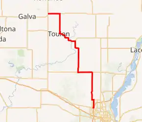
Illinois Route 91 (IL 91) is a rural state road in central Illinois. It runs from the northwest edge of Peoria at U.S. Highway 150 (US 150 to U.S. Highway 34 south of Kewanee. Illinois 91 is 40.72 miles (65.53 km) long.[1]
| ||||
|---|---|---|---|---|

| ||||
| Route information | ||||
| Maintained by IDOT | ||||
| Length | 40.72 mi[1] (65.53 km) | |||
| Existed | 1941[2]–present | |||
| History | Signed as IL 30 before 1941[3] | |||
| Major junctions | ||||
| South end | ||||
| North end | ||||
| Location | ||||
| Counties | Peoria, Stark, Henry | |||
| Highway system | ||||
| ||||
Route description
IL 91 serves the cities of Toulon, Wyoming, Princeville, and Dunlap. It travels concurrently with IL 90 around Princeville.
IL 91 does not travel in a straight line between any two major towns. IL 91's endpoints are generally northwest-to-southeast, but the route consists entirely of north–south and east–west stretches.
The Rock Island Trail State Park follows IL 91 for much of its length. This State Park trail is the former right-of-way of a Peoria branch line of the Chicago, Rock Island and Pacific Railroad.
History
SBI Route 91 was the current U.S. Route 150 from Knoxville to Peoria. Prior to 1936, Illinois Route 30 mostly followed present-day IL 91 and a part of IL 17 east of Galva.[4] Later, IL 30 was rerouted north of Toulon which entirely followed current IL 91.[5] In March 1941, the state announced that IL 91 was replacing the designation of IL 30 from Kewanee to US 150,[2] and has remained so to this day.[3][6]
Major intersections
| County | Location | mi[7] | km | Destinations | Notes |
|---|---|---|---|---|---|
| Peoria | Peoria | 0.0 | 0.0 | ||
| | 10.7 | 17.2 | South end of IL 90 concurrency | ||
| Princeville | 15.0 | 24.1 | North end of IL 90 concurrency | ||
| Stark | Wyoming | 25.5 | 41.0 | South end of IL 17 concurrency | |
| Toulon | 31.5 | 50.7 | North end of IL 17 concurrency | ||
| | 37.3 | 60.0 | |||
| Henry | | 40.72 | 65.53 | ||
1.000 mi = 1.609 km; 1.000 km = 0.621 mi
| |||||
References
- Illinois Technology Transfer Center (2006). "T2 GIS Data". Retrieved 2007-11-08.
- "New State Road Map Completed". Edwardsville Intelligencer. March 22, 1941. p. 2. Retrieved November 6, 2015 – via Newspapers.com.

- Carlson, Rich. Illinois Highways Page: Routes 81 thru 100. Last updated April 15, 2005. Retrieved April 16, 2006.
- Illinois Secretary of State; Rand McNally (1936). Road Map Illinois (Map). [c. 1:950,000 and c. 1:1,110,000]. Springfield: Illinois Secretary of State – via Illinois Digital Archives.
- Illinois Secretary of State; Rand McNally (1939). Illinois Road Map (Map) (1939–1940 ed.). c. 1:918,720. Springfield: Illinois Secretary of State – via Illinois Digital Archives.
- Illinois Secretary of State; Rand McNally (1942). Illinois Road Map (Map). c. 1:918,720. Springfield: Illinois Secretary of State – via Illinois Digital Archives.
- Google (February 24, 2015). "Overview Map of IL 91" (Map). Google Maps. Google. Retrieved February 24, 2015.
