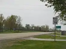
Illinois Route 78
Illinois Route 78 is a major north–south highway in western Illinois. It runs from Illinois Route 104 northwest of Jacksonville north to Highway 78 at the Wisconsin state line north of Warren. This is a distance of 215.51 miles (346.83 km).[1]
| ||||
|---|---|---|---|---|
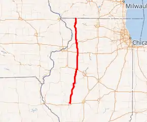
IL 78 highlighted in red | ||||
| Route information | ||||
| Maintained by IDOT | ||||
| Length | 215.51 mi[1] (346.83 km) | |||
| Existed | 1924[2]–present | |||
| Major junctions | ||||
| South end | ||||
| North end | ||||
| Location | ||||
| Counties | Morgan, Cass, Mason, Fulton, Knox, Peoria, Stark, Henry, Whiteside, Carroll, Jo Daviess | |||
| Highway system | ||||
| ||||

Route description
Jacksonville to Elmwood
Starting from IL 104 in Jacksonville, IL 78 briefly travels east, then south, and then east again. Then, it turns north via Main Street, passing the Jacksonville Municipal Airport. As it continues north, it then reaches IL 125 in Virginia. In Havana, US 136, as well as IL 97, begins to run concurrently with IL 78. US 136 then leaves the concurrency just west of the Scott W. Lucas Bridge. At the US 24 junction, IL 97 branches off west via US 24 while IL 78 travels east via US 24. In Little America, IL 78 branches off north from US 24. Then, IL 9 runs concurrently with IL 78 in Canton. In Farmington, IL 78 turns east via IL 116 and then back north again; branching off north from IL 116. In Elmwood, it follows IL 8 east and then north before branching off north.[4]
Elmwood to Wisconsin state line
Further north, IL 78 then crosses under I-74 without a direct interchange. It then turns east and then north again. As it turns back north, it then follows US 150 for 3 miles (4.8 km). After that, it then intersects IL 90 north of Laura, then briefly runs concurrently with IL 17, then with US 34, and then intersects with IL 91. In Kewanee, US 34 then branches off northeast. North of the junction, IL 81 ends at the intersection with IL 78. In Annawan, it crosses US 6 and then I-80 at a diamond interchange. Further north, IL 78 then runs concurrently with IL 92, then meets I-88/IL 110 (CKC) at a diamond interchange, and then runs concurrently with US 30 in Morrison. IL 40 ends at an intersection south of Mount Carroll. In Mount Carroll, it intersects US 52/IL 64. Further north, in Stockton, IL 78 then runs concurrently with US 20. In Warren, it then turns northwest before reaching the Wisconsin state line. At that point, IL 78 becomes WIS 78.[4]
History
Starting in 1929, IL 78 first appeared as segments while the rest were under construction.[5] Within a few years, most of IL 78 from Jacksonville to Warren was finished.[6] In 1935, IL 78 superseded portions of IL 82, IL 3, and IL 40. However, a section between Jacksonville and Virginia became part of US 67.[7] By the late 1930s, a portion of IL 78 was moved onto a more direct route between Maples Mill and West Havana.[8] It remained like that until 1968 when US 67 rerouted away from Virginia. This resulted in the extension of IL 78 from Virginia to Jacksonville.[9]
Points of interest
The following historic and geographic sites can be enjoyed on Illinois Route 78, traveling from south to north:
Major intersections
| County | Location | mi[4] | km | Destinations | Notes |
|---|---|---|---|---|---|
| Morgan | Jacksonville | 0.00 | 0.00 | Southern terminus of IL 78 | |
| Cass | Virginia | 17.7 | 28.5 | ||
| Mason | Havana | 44.2 | 71.1 | Begin/end concurrency with US 136 and IL 97 | |
| Illinois River | 44.5 | 71.6 | Scott W. Lucas Bridge | ||
| Fulton | Isabel Township | 45.3 | 72.9 | Begin/end concurrency with US 136 | |
| Waterford Township | 52.0 | 83.7 | Begin/end concurrency with US 24 / IL 97 | ||
| Little America | 55.1 | 88.7 | Begin/end concurrency with US 24 | ||
| Buckheart Township | 61.5 | 99.0 | Eastern terminus of IL 100 | ||
| Canton | 64.7 | 104.1 | Begin/end concurrency with IL 9 | ||
| 65.9 | 106.1 | Begin/end concurrency with IL 9 | |||
| Farmington | 76.2 | 122.6 | Begin/end concurrency with IL 116 | ||
| Fulton–Peoria county line | Farmington Township | 77.2 | 124.2 | Begin/end concurrency with IL 116 | |
| Knox | Salem Township | 82.8 | 133.3 | Begin/end concurrency with IL 8 | |
| Peoria | Elmwood | 85.0 | 136.8 | Begin/end concurrency with IL 8 | |
| Brimfield Township | 91.5 | 147.3 | Begin/end concurrency with US 150; connection to exit 71 (I-74) | ||
| Millbrook Township | 94.5 | 152.1 | Begin/end concurrency with US 150 | ||
| 96.5 | 155.3 | Western terminus of IL 90 | |||
| Stark | Goshen Township | 108.2 | 174.1 | Begin/end concurrency with IL 17 | |
| 108.6 | 174.8 | Begin/end concurrency with IL 17 | |||
| Henry | Wethersfield Township | 113.1 | 182.0 | Begin/end concurrency with US 34 | |
| 113.7 | 183.0 | Northern terminus of IL 91 | |||
| Kewanee | 118.3 | 190.4 | Begin/end concurrency with US 34 | ||
| 118.6 | 190.9 | Eastern terminus of IL 81 | |||
| Annawan | 129.3 | 208.1 | |||
| 129.8 | 208.9 | Exit 33 (I-80) | |||
| Yorktown Township | 140.8 | 226.6 | Begin/end concurrency with IL 92 | ||
| 141.7 | 228.0 | Begin/end concurrency with IL 92 | |||
| Whiteside | Lyndon Township | 154.6 | 248.8 | Exit 26 (I-88) | |
| Morrison | 160.8 | 258.8 | Begin/end concurrency with US 30 | ||
| 162.3 | 261.2 | Begin/end concurrency with US 30 | |||
| Carroll | Mount Carroll | 180.4 | 290.3 | Northern terminus of IL 40 | |
| 180.8 | 291.0 | ||||
| Jo Daviess | Stockton | 201.5 | 324.3 | Begin/end concurrency with US 20 | |
| Stockton Township | 202.8 | 326.4 | Begin/end concurrency with US 20 | ||
| Warren Township | 215.51 | 346.83 | Wisconsin state line; northern terminus of IL 78 | ||
| 1.000 mi = 1.609 km; 1.000 km = 0.621 mi | |||||
References
- Illinois Technology Transfer Center (2006). "T2 GIS Data". Retrieved 2007-11-08.
- Carlson, Rich. Illinois Highways Page: Routes 61 thru 80. Last updated April 15, 2005. Retrieved April 14, 2006.
- Unknown. New U.S. 67 Gallery Archived 2006-05-05 at the Wayback Machine. Last updated June 14, 2001. Retrieved April 14, 2006.
- Google (February 22, 2017). "Overview Map of IL 78" (Map). Google Maps. Google. Retrieved February 22, 2017.
- Illinois Secretary of State; H.M. Gousha (1929). Illinois Official Auto Road Map (Map). [c. 1:950,000 and c. 1:1,110,000]. Springfield: Illinois Secretary of State. Retrieved September 20, 2020 – via Illinois Digital Archives.
- Illinois Secretary of State; Rand McNally (1934). Official Road Map Illinois (Map). [c. 1:950,000 and c. 1:1,110,000]. Springfield: Illinois Secretary of State. OCLC 183709045. Retrieved September 20, 2020 – via Illinois Digital Archives.
- Illinois Secretary of State; H.M. Gousha (1935). Official Road Map Illinois (Map). [c. 1:950,000 and c. 1:1,110,000]. Springfield: Illinois Secretary of State. Retrieved September 20, 2020 – via Illinois Digital Archives.
- Illinois Secretary of State; Rand McNally (1939). Illinois Road Map (Map) (1939–1940 ed.). c. 1:918,720. Springfield: Illinois Secretary of State. Retrieved September 20, 2020 – via Illinois Digital Archives.
- Illinois Division of Highways (1968). Illinois Official Highway Map (Map). [1:772,500]. Springfield: Illinois Division of Highways. Retrieved September 20, 2020 – via Illinois Digital Archives.
External links
| Wikimedia Commons has media related to Illinois Route 78. |
