U.S. Route 150
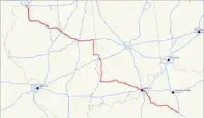
U.S. Route 150 (US 150) is a 571-mile (919 km) long northwest-southeast United States highway, signed as east–west. It runs from U.S. Route 6 outside of Moline, Illinois to U.S. Route 25 in Mount Vernon, Kentucky.
| |
|---|---|
 | |
| Route information | |
| Auxiliary route of US 50 | |
| Length | 571 mi (919 km) |
| Existed | 1926–present |
| Major junctions | |
| West end | |
| East end | |
| Location | |
| States | Illinois, Indiana, Kentucky |
| Highway system | |

Route description
Illinois
In the state of Illinois, U.S. 150 runs from the Quad City International Airport at U.S. Route 6 southeast to near Vermilion. U.S. 150 in Illinois is 267.47 miles (430.45 km) long.[1]
Between Moline and Danville, Route 150 closely parallels Interstate 74.
Indiana
In the state of Indiana, U.S. 150 runs south with U.S. Route 41 from Terre Haute. It is then concurrent with its parent, U.S. Route 50 from Vincennes to Shoals. It then runs east to New Albany before overlapping Interstate 64 into Kentucky. Between Vincennes and New Albany the road follows the original route of the Buffalo Trace.
Kentucky
U.S. 150 runs concurrently with I-64 as it enters Kentucky from Indiana, crossing the Ohio River into Louisville on the Sherman Minton Bridge and exiting the I-64 freeway at North 22nd Street in the Portland neighborhood. From there, U.S. 150 runs south to West Broadway (westbound U.S. 150 follows Dr. W. J. Hodges Street from West Broadway to West Main Street, then runs along the 22nd Street Connector to its merge with North 22nd near Garfield Avenue); U.S. 150 follows Broadway across downtown to Baxter Avenue; after a brief run along Baxter, It then follows Bardstown Road, a major radial artery running southeasterly from downtown, with interchanges at Interstates 264 and 265.
Between West Main and West Broadway in Louisville, U.S. 150 is concurrent with U.S. Route 31W; from East Broadway and Baxter to Bardstown, Kentucky, it is concurrent with U.S. Route 31E. The route along Baxter Avenue and Bardstown Road follows the former Louisville and Bardstown Turnpike through the Highlands district of Louisville and past the historic Farmington plantation at the interchange with the Watterson Expressway (I-264).
U.S. routes 150 and 31E separate at Bardstown near the Martha Layne Collins Blue Grass Parkway. U.S. 150 then continues southeast, around the city of Danville before terminating at Mount Vernon.
History
Illinois
Before 1936, Illinois Route 39 ran from Bloomington to Champaign on the current routing of U.S. 150.[2][3] In 1936, US 150 extended due northwest from Shoals, Indiana to the Quad Cities. As a result, IL 39 and IL 91 were decommissioned. Not only that, IL 16, IL 80, and IL 121 were truncated.[4] In 1954, a portion of US 150 in Peoria moved from the Franklin Street Bridge to the McClugage Bridge. As a result, US 150 City, later US 150 Bus., appeared in Peoria from 1954 to 1964.[5][6] In 1971, the decision to remove a portion of US 150 from US 67 in Rock Island to I-74 in Danville failed.[7] However, in 1976, the decision to truncate US 150 from US 67 in Rock Island to US 6 near the Quad City Airport was approved.[8][9]
Indiana
Initially, US 150 ran from Shoals, Indiana to Louisville, Kentucky.[10] In 1936, US 150 extended due northwest from Shoals to the Quad Cities in Illinois. This caused IN 46 to cut back from the Illinois state line to Terre Haute.[4]
Kentucky
| |
|---|---|
| Location | Louisville–Mount Vernon |
| Existed | 1926–1934 |
U.S. Route 168 was created in 1926 from Louisville to Mount Vernon, Kentucky, overlapping US 68 between Bardstown and Perryville. In 1934, US 150 absorbed US 168.
Major intersections
| State | County | Location | mi | km | Destinations | Notes | ||
|---|---|---|---|---|---|---|---|---|
| Illinois | Rock Island | Moline | 0.0 | 0.0 | ||||
| Henry | | |||||||
| | Western end of IL 17 overlap | |||||||
| | Eastern end of IL 17 overlap | |||||||
| Knox | Galesburg | Interchange | ||||||
| | ||||||||
| | I-74 exit 54 | |||||||
| Peoria | | |||||||
| | Western end of IL 78 overlap | |||||||
| | Eastern end of IL 78 overlap | |||||||
| | ||||||||
| Brimfield | ||||||||
| Kickapoo | ||||||||
| Peoria | ||||||||
| IL 6 exit 2 | ||||||||
| I-74 exit 89; no direct access from US 150 east to I-74 west or I-74 east to US 150 west | ||||||||
| Interchange | ||||||||
| Illinois River | McClugage Bridge | |||||||
| Tazewell | East Peoria | Interchange; western end of US 24 / IL 116 overlap; US 150 and US 24 switch carriageways | ||||||
| I-74 exit 95A; western end of IL 29 overlap | ||||||||
| Eastern end of US 24 / IL 29 / IL 116 overlap; western end of IL 8 overlap | ||||||||
| I-74 exit 95B; eastbound exit and westbound entrance | ||||||||
| Eastern end of IL 8 overlap | ||||||||
| Woodford | Goodfield | |||||||
| McLean | | I-74 exit 125 | ||||||
| Bloomington | Western end of IL 9 overlap | |||||||
| I-55 exit 160 | ||||||||
| Eastern end of IL 9 overlap | ||||||||
| Alternate route of Historic US 66 | ||||||||
| | ||||||||
| DeWitt | Farmer City | |||||||
| Piatt |
No major junctions | |||||||
| Champaign | Mahomet | Western end of IL 47 overlap | ||||||
| Eastern end of IL 47 overlap | ||||||||
| Champaign | ||||||||
| Western end of US 45 overlap | ||||||||
| Urbana | Eastern end of US 45 overlap | |||||||
| Western end of IL 130 overlap | ||||||||
| Eastern end of IL 130 overlap | ||||||||
| Ogden | Western end of IL 49 overlap | |||||||
| Vermilion | DeLong | Eastern end of IL 49 overlap | ||||||
| | I-74 exit 210 | |||||||
| Danville | Western end of IL 1 overlap | |||||||
| Tilton | I-74 exit 215 | |||||||
| 14th Street | Interchange | |||||||
| Edgar | | |||||||
| Paris | Eastern end of IL 1 overlap | |||||||
| Indiana | Vigo | West Terre Haute | Former US 40 west | |||||
| Terre Haute | Western end of US 41 overlap; former US 40 east | |||||||
| see US 41 and US 50 | ||||||||
| Martin | Shoals | Eastern end of US 50 overlap | ||||||
| Lacy | ||||||||
| Orange | Prospect | Western end of SR 56 overlap | ||||||
| Paoli | Western end of SR 37 overlap | |||||||
| Eastern end of SR 37 overlap; traffic circle around Orange County Courthouse | ||||||||
| Eastern end of SR 56 overlap | ||||||||
| Washington | Fayetteville | |||||||
| Harrison | Palmyra | |||||||
| Floyd | Greenville | |||||||
| | Western end of I-64 / SR 62 overlap; US 150 west follows exit 119 | |||||||
| | Eastern end of SR 62 overlap; I-64 exit 121; I-265 exit 0 | |||||||
| New Albany | New Albany | I-64 exit 123 | ||||||
| Ohio River | Sherman Minton Bridge | |||||||
| Kentucky | Jefferson | Louisville | I-64 exit 1; I-264 exit 0 | |||||
| Eastern end of I-64 overlap; US 150 east follows exit 3 | ||||||||
| KY 3064 west (Portland Avenue) | Eastern terminus of unsigned KY 3064; one-way westbound only | |||||||
| KY 3082 (Bank Street) | Eastern terminus of unsigned KY 3082; KY 3082 is one-way eastbound onto US 150 only | |||||||
| Western end of US 31W / US 60 overlap | ||||||||
| Eastern end of US 31W / US 60 overlap | ||||||||
| Western end of US 31E overlap | ||||||||
| see US 31E | ||||||||
| Nelson | Bardstown | Eastern end of US 31E overlap; western end of US 62 overlap; traffic circle around Old Courthouse Building | ||||||
| Eastern end of US 62 overlap | ||||||||
| Western end of US 31E Truck overlap | ||||||||
| Bluegrass Parkway exit 25; eastern end of US 31E Truck overlap | ||||||||
| | Western end of KY 605 overlap | |||||||
| Botland | Eastern end of KY 605 overlap | |||||||
| Washington | Fredericktown | |||||||
| | ||||||||
| | ||||||||
| | ||||||||
| | ||||||||
| | ||||||||
| Springfield | ||||||||
| | ||||||||
| | ||||||||
| | ||||||||
| Rineltown | ||||||||
| | ||||||||
| | ||||||||
| Boyle | Perryville | |||||||
| Western end of US 68 / KY 52 overlap | ||||||||
| Eastern end of US 68 overlap | ||||||||
| | Western end of KY 1822 overlap | |||||||
| Needmore | Eastern end of KY 1822 overlap | |||||||
| Danville | ||||||||
| Western end of KY 34 overlap | ||||||||
| Western end of US 127 overlap | ||||||||
| Eastern end of US 127 south overlap (eastbound) | ||||||||
| Eastern end of US 127 north overlap (westbound) | ||||||||
| Eastern end of KY 34 overlap | ||||||||
| Eastern end of KY 52 overlap | ||||||||
| | ||||||||
| | Western end of KY 1273 overlap | |||||||
| | Eastern end of KY 1273 overlap | |||||||
| Lincoln | | |||||||
| Stanford | ||||||||
| | ||||||||
| | ||||||||
| | ||||||||
| | ||||||||
| | ||||||||
| | ||||||||
| | Western end of KY 2750 overlap | |||||||
| | Eastern end of KY 2750 overlap | |||||||
| Rockcastle | | Fort Harrod Way | Former KY 2750 | |||||
| | ||||||||
| | ||||||||
| | ||||||||
| | ||||||||
| | ||||||||
| Maretburg | ||||||||
| | ||||||||
| | ||||||||
| Mount Vernon | ||||||||
1.000 mi = 1.609 km; 1.000 km = 0.621 mi
| ||||||||
Special routes
Springfield business loop
| |
|---|---|
| Location | Springfield |
U.S. Route 150 Business (US 150 Bus.) is a special U.S. Route in Springfield, Kentucky. The route runs through downtown Springfield while US 150 bypasses the town to the northeast. It intersects Kentucky state highways 152, 555, 528, 1584, and 1404.
Danville bypass
| |
|---|---|
| Location | Danville |
U.S. Route 150 Bypass (US 150 Byp.) is a special U.S. Route in Danville, Kentucky. The route bypasses Danville to the southwest while US 150 runs through downtown. The route is overlapped by US 127 Byp. for approximately the first half of its length. It intersects US 127, along with Kentucky state routes 34 and 37.
See also
- U.S. Route 50
- U.S. Route 250
- U.S. Route 350
- U.S. Route 450
- U.S. Route 550
- U.S. Route 650
- Roads in Louisville, Kentucky
References
- Illinois Technology Transfer Center (2006). "T2 GIS Data". Retrieved 2007-11-08.
- Carlson, Rich (2007-02-03). "Illinois Highways Page: Routes 21 thru 40". Retrieved 2007-02-23.
- Illinois Secretary of State; H.M. Gousha (1935). Official Road Map Illinois (Map). [c. 1:950,000 and c. 1:1,110,000]. Springfield: Illinois Secretary of State. Retrieved October 12, 2020 – via Illinois Digital Archives.
- Illinois Secretary of State; Rand McNally (1936). Road Map Illinois (Map). [c. 1:950,000 and c. 1:1,110,000]. Springfield: Illinois Secretary of State. Retrieved October 12, 2020 – via Illinois Digital Archives.
- Illinois Division of Highways (1954). Illinois Official Highway Map (Map). [1:805,000]. Springfield: Illinois Division of Highways. Retrieved October 12, 2020 – via Illinois Digital Archives.
- Illinois Division of Highways; Rand McNally (1964). Illinois Official Highway Map (Map). [1:757,500]. Springfield: Illinois Division of Highways. Retrieved October 12, 2020 – via Illinois Digital Archives.
- U.S. Route Numbering Subcommittee (December 3, 1971). "U.S. Route Numbering Subcommittee Agenda" (PDF) (Report). Washington, DC: American Association of State Highway Officials. p. 2. Retrieved October 30, 2020 – via Wikimedia Commons.
- Illinois Department of Transportation (1977). Illinois Highway Map (Map). [1:772,500]. Springfield: Illinois Department of Transportation. Retrieved October 12, 2020 – via Illinois Digital Archives.
- Special Committee on U.S. Route Numbering (November 12, 1976). "Route Numbering Committee Agenda" (PDF) (Report). Washington, DC: American Association of State Highway and Transportation Officials. p. 2. Retrieved October 12, 2020 – via Wikimedia Commons.
- "1932 Indiana Highway Map" (PDF). Retrieved October 12, 2020.