Interstate 376 Business
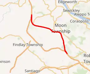
Interstate 376 Business (I-376 Bus.), commonly referred to as Business Loop 376 or simply Business 376, is a 6.88-mile-long (11.07 km) business loop of I-376 in Allegheny County, Pennsylvania. It is located almost entirely within Moon Township and serves both the township and the cargo and services areas of Pittsburgh International Airport. The road is a part of the Beaver Valley Expressway from its western terminus to University Boulevard and part of the Airport Parkway from University Boulevard to its eastern terminus.[1] It is officially known as the 99th Infantry Division Memorial Highway for its entire length.[1][2] Though mostly a freeway, a short section in the middle of the route has at-grade signalized intersections.
| |
|---|---|
| 99th Infantry Division Memorial Highway | |

I-376 Business highlighted in red | |
| Route information | |
| Business route of I-376 | |
| Maintained by PennDOT | |
| Length | 6.88 mi[1] (11.07 km) |
| Existed | 2009–present |
| History | Replaced PA 60 Business in 2009 |
| Major junctions | |
| West end | |
| East end | |
| Location | |
| Counties | Allegheny |
| Highway system | |
| |
It is one of only two business loops of an Interstate Highway in the Commonwealth of Pennsylvania, the other being I-83 Bus. Originally, the route was a part of Pennsylvania Route 60 (PA 60) before becoming Pennsylvania Route 60 Business (PA 60 Bus.) in 1992. In 2009, PA 60 was truncated to its current northern terminus as I-376 was extended in its place to Hermitage, causing the route to be redesignated as I-376 Bus.
Route description
Business Loop 376 diverges from I-376 at a partial interchange in Findlay Township, heading due south as a continuation of the Beaver Valley Expressway with a wide grass median. The road immediately turns east, meeting Flaugherty Run Road at a diamond interchange which allows indirect access to the remaining movements for I-376. Heading east, Business Loop 376 comes to a diamond interchange with International Drive, which provides access to three of the cargo areas of Pittsburgh International Airport. Further east, the median narrows and the road curves southeast before coming to a signalized intersection with Hangar Road, which connects to the airport service area, marking the end of the Beaver Valley Expressway.
Business Loop 376 turns east again as a four-lane, at-grade limited-access road before intersecting University Boulevard to the north and Horizon Drive to the south. This intersection is the beginning of the Airport Parkway, at which point a wide grass median begins again. The third and final signalized intersection on the route is with Airside Drive, leading to more of the airport's cargo areas. The median narrows again as Business Loop 376 curves south-southeast as a freeway once again. The road intersects Thorn Run Road and then Ewing Road before ending at I-376. The Airport Parkway name continues onto I-376 to the east.
History
The Airport Parkway section of the route was built in the early 1950s as a four-lane, at-grade limited-access road connecting what was then Beers School Road (today University Boulevard) at the former Pittsburgh International Airport terminals to McClaren Road at the site of the current eastern terminus of the route. In 1962, the road became part of an extended PA 60, which continued north along what is now University Boulevard to PA 51.[3]
Construction began in the late 1960s on the Beaver Valley Expressway section of the road, which opened by 1971. At the time, the freeway abruptly ended at a stub just east of the current International Drive interchange. Traffic was diverted off the mainline onto a temporary connector road which fed into the current at-grade four-lane divided portion of the route. Original plans called for the Beaver Valley Expressway to be extended east to directly connect to the freeway portion of the Airport Parkway. This plan was cancelled in the 1970s,[4] causing a short gap in the freeway portion of PA 60.
| |
|---|---|
| Location | Moon Township–Findlay Township |
| Length | 6.88 mi[1] (11.07 km) |
| Existed | 1992–2009[5][1] |
In 1992, the Southern Expressway opened, connecting to the new Pittsburgh International Airport terminal.[5] The PA 60 designation was rerouted onto it, creating PA 60 Bus. in its place.

In order to increase the accessibility of the cargo areas, International Drive was built, and with it came a new interchange. The project also involved reconstructing the road to the east of the interchange, removing the stub of the cancelled Beaver Valley Expressway extension and improving the transition from freeway to limited-access highway. Construction began in 2001 and finished in 2003.[6]
I-376 was extended to I-80 near Hermitage in 2009, and PA 60 was cut back to its current northern terminus. As a result, PA 60 Bus. was decommissioned and replaced with Business Loop 376.
Major intersections
The entire route is in Allegheny County.
| Location | mi | km | Destinations | Notes | |
|---|---|---|---|---|---|
| Findlay Township | 0.00 | 0.00 | Western terminus of I-376 Business; access only from eastbound and to westbound I-376 | ||
| Findlay Township–Moon Township line | 1.13 | 1.82 | Interchange; I-376 not signed eastbound | ||
| Moon Township | 2.21 | 3.56 | International Drive | Interchange; access to cargo areas 1, 2, and 3 | |
| 2.99 | 4.81 | Halverson Drive | Eastbound entrance only | ||
| 3.62 | 5.83 | Hangar Service Road | At-grade intersection; access to airport service area and airport maintenance facilities | ||
| 3.87 | 6.23 | At-grade intersection; western end of concurrency with Orange Belt; no left turn westbound onto Horizon Drive | |||
| 4.02 | 6.47 | Airside Drive | At-grade jughandle intersection; access to Airside Business Park and cargo areas A and B | ||
| 4.59 | 7.39 | Thorn Run Road – Sewickley, Coraopolis, Pittsburgh IAP Air Reserve Station | Interchange; access to Airport Office Park | ||
| 5.82 | 9.37 | Ewing Road – Coraopolis | Interchange | ||
| 6.88 | 11.07 | Eastern terminus of I-376 Business; eastern end of concurrency with Orange Belt | |||
1.000 mi = 1.609 km; 1.000 km = 0.621 mi
| |||||
See also
 U.S. Roads portal
 Pennsylvania portal
References
- Kitsko, Jeffrey J. (December 1, 2013). "Interstate 376 Business Routes". Pennsylvania Highways. Retrieved September 29, 2018.
- http://www.legis.state.pa.us/WU01/LI/LI/US/PDF/2001/0/0001..PDF
- Kitsko, Jeffrey J. (December 17, 2015). "PA 51–PA 100". Pennsylvania Highways. Retrieved September 29, 2018.
- Kitsko, Jeffrey J. (January 29, 2010). "Pittsburgh Highways: Beaver Valley Expressway". Pennsylvania Highways. Retrieved September 29, 2018.
- Thorner, Jim (September 16, 1992). "Airport Expressway is born". The Weekly Times. Beaver Newspapers. p. 1. Retrieved April 14, 2010 – via Google News.
- Kitsko, Jeffrey J. (December 17, 2015). "PA 51–PA 100". Pennsylvania Highways. Retrieved September 29, 2018.
External links
| Wikimedia Commons has media related to Interstate 376 Business. |
