Interstate 444
Interstate 444 (I-444) is an unsigned auxiliary route of the Interstate Highway System, with both ends at I-244 in downtown Tulsa in the U.S. state of Oklahoma. It makes up the eastern and southern sections on the square-shaped Inner Dispersal Loop.
| ||||
|---|---|---|---|---|
| Inner Dispersal Loop | ||||
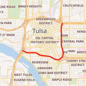
I-444 highlighted in red | ||||
| Route information | ||||
| Auxiliary route of I-44 | ||||
| Maintained by ODOT | ||||
| Length | 2.51 mi[1] (4.04 km) | |||
| Existed | early 1970s–present | |||
| Major junctions | ||||
| West end | ||||
| East end | ||||
| Location | ||||
| Counties | Tulsa | |||
| Highway system | ||||
|
Oklahoma State Highway System
| ||||
.svg.png.webp)
It is signed as US-75, with the first half of the highway also being signed as US-64 and State Highway 51 (SH-51). The I-444 designation does appear on Rand McNally maps, and also on some online maps, such as Bing Maps.
History
At the time I-44 was designated, the mile markers in the Tulsa area were in the 90s range. Rather than having their own numbers, I-244 and I-444 started their numbering based on what mile marker the highways were at when they branched off. Therefore, one exit along I-444 was labeled "94D". When the I-444 signs were removed from the highway and the "94" numbers were removed from the other markers (their gore signs simply bore the letter suffixes "A", "B", and "C") the 94D marking remained. The number became even more out of place when the other signs were replaced, bearing no exit numbers.[2]
Exit list
Exit numbers and mileposts no longer exist (see #History section above for explanation of exit numbers). The entire route is in Tulsa, Tulsa County.
| mi | km | Old exit | New exit | Destinations | Notes | ||
|---|---|---|---|---|---|---|---|
| 0.00 | 0.00 | 94A | Western terminus; I-244 exit 4B; western end of US-75 concurrency | ||||
| 94B | Westbound exit and eastbound entrance; Western end of US-64/SH-51 concurrency | ||||||
| 94C | 11th Street / Houston Avenue | Westbound exit and eastbound entrance | |||||
| 94D | 13th Street / Denver Avenue / Cheyenne Avenue | ||||||
| 95 | Eastern end of US-64/SH-51 concurrency | ||||||
| 96A | 7th Street – Downtown | ||||||
| 2.51 | 4.04 | 96B | Eastbound exit and westbound entrance | ||||
| 96C | Eastern terminus; old exit number was for I-244/US 412; I-244 exit 6B; eastern end of US-75 concurrency | ||||||
1.000 mi = 1.609 km; 1.000 km = 0.621 mi
| |||||||
References
- "Table 2: Auxiliary Routes of the Dwight D. Eisenhower National System Of Interstate and Defense Highways as of October 31, 2002". Federal Highway Administration. Retrieved October 16, 2013.
- "Tulok.net". Archived from the original on May 9, 2008. Retrieved October 16, 2013.
External links
 Media related to Interstate 444 at Wikimedia Commons
- Tulok.Net Side Trips - Wherefore Art Thou 94D
- OKHighways.com - Hidden Interstate 444
| ||