Interstate 44 in Texas
In the U.S. state of Texas, Interstate 44 (I-44) has a short but regionally important 14.77-mile (23.77 km) stretch, connecting Wichita Falls with Oklahoma. Its entire length is concurrent with U.S. Highway 277 and U.S. Highway 281. I-44 provides access to downtown Wichita Falls and Sheppard Air Force Base. Interstate 44 is known as Central Freeway in Wichita Falls and Red River Expressway in Burkburnett.
| ||||
|---|---|---|---|---|
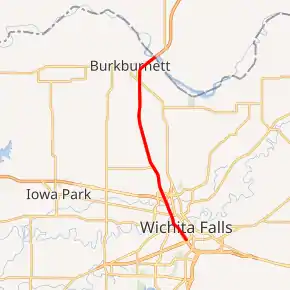
I-44 highlighted in red | ||||
| Route information | ||||
| Maintained by TxDOT | ||||
| Length | 15.398 mi[1] (24.781 km) | |||
| Existed | 1982[2]–present | |||
| Major junctions | ||||
| West end | ||||
| East end | ||||
| Location | ||||
| Counties | Wichita | |||
| Highway system | ||||
| ||||
.svg.png.webp)
Route description
I-44 begins near exit 1 in Wichita Falls concurrent with US 277, US 281 and US 287. US 281 and US 287 continue to the south while US 277 leaves the concurrency at exit 1, which also provides access to US 82. I-44 heads north through Wichita Falls to an interchange with US 287 and Spur 325. US 287 leaves the concurrency as a freeway to the west while Spur 325 leaves the interchange towards the northeast providing access to Sheppard Air Force Base and Wichita Falls Municipal Airport. I-44 continues to the north as it leaves the Wichita Falls city limits at Bacon Switch Road. The freeway enters the Burkburnett city limits south of an interchange at FM 3429. Heading north through the city, I-44 has interchanges with SH 240 and Spur 383. After passing Spur 383, I-44 begins to head towards the northeast before its final interchange in Texas at Loop 267. I-44 leaves the state of Texas at its crossing of the Red River and enters Oklahoma.[3]
History
I-44 was signed south from Oklahoma City past I-40, along the H. E. Bailey Turnpike, in 1982.[4][5] This expanded the interstate by some 100 miles (160 km) to Texas. This additional signage included the Red River Expressway in Burkburnett and the Central Freeway in Wichita Falls, to 8th street (being concurrent with US 277/281/287). For many years, the freeway ended here, forcing traffic to exit onto the service roads. In the early 2000s, the Central Freeway was extended through the downtown area, connecting directly to the Central East Freeway via the Lloyd Ruby Overpass.
Exit list
The entire route is in Wichita County.
| Location | mi[6] | km | Exit | Destinations | Notes | |
|---|---|---|---|---|---|---|
| Wichita Falls | 0.0 | 0.0 | Continuation beyond western terminus; west end of US 277/US 281/US 287 concurrency | |||
| 0.2 | 0.32 | 1 | Westbound exit and eastbound entrance, access to United Regional Healthcare System | |||
| 0.4 | 0.64 | 1A | Westbound exit and eastbound entrance | |||
| 0.8 | 1.3 | 1B | Scotland Park | Eastbound exit and westbound entrance | ||
| 1.3 | 2.1 | 1C | Texas Travel Info Center | |||
| 2.0 | 3.2 | 1D | ||||
| 2.2 | 3.5 | 2 | Maurine Street | |||
| 2.7 | 4.3 | 3A | East end of US 287 concurrency | |||
| 2.9 | 4.7 | 3B | ||||
| 3.5 | 5.6 | 3C | ||||
| 4.2 | 6.8 | 4 | City Loop | No westbound entrance; exit not signed westbound | ||
| 5.1 | 8.2 | 5 | Access Road | Eastbound exit and westbound entrance | ||
| 5.5 | 8.9 | 5A | ||||
| 6.7 | 10.8 | 6 | Bacon Switch Road | |||
| | 7.8 | 12.6 | 7 | East Road | ||
| Burkburnett | 10.9 | 17.5 | 11 | |||
| 12.4 | 20.0 | 12 | ||||
| 13.4 | 21.6 | 13 | ||||
| 14.1 | 22.7 | 14 | Former Loop 267 | |||
| | 15.4 | 24.8 | Continuation into Oklahoma | |||
1.000 mi = 1.609 km; 1.000 km = 0.621 mi
| ||||||
References
- Federal Highway Administration, Route Log and Finder List: Table 1: Main Routes of the Dwight D. Eisenhower National System Of Interstate and Defense Highways as of October 31, 2002
- Transportation Planning and Programming Division (n.d.). "Interstate Highway No. 44". Highway Designation Files. Texas Department of Transportation. Retrieved July 22, 2014.
- Google (2008-02-25). "overview map of I-44" (Map). Google Maps. Google. Retrieved 2008-02-25.
- "I-240 Section Changing to I-44". The Daily Oklahoman. 1982-10-09.
- 1983 Official State Map (Map) (1983 ed.). Oklahoma Department of Transportation.
- Google (May 9, 2018). "Route of I-44" (Map). Google Maps. Google. Retrieved May 9, 2018.
| Previous state: Terminus |
Texas | Next state: Oklahoma |