Interstate 74 in Ohio
Interstate 74 (I-74) in the U.S. state of Ohio runs for 19.47 miles (31.33 km) southeast from the Indiana border to the western segment's current eastern terminus at Interstate 75 just north of downtown Cincinnati. It is also signed with U.S. Route 52 for its entire length.
| ||||
|---|---|---|---|---|
I-74 highlighted in red | ||||
| Route information | ||||
| Maintained by ODOT | ||||
| Length | 19.47 mi[1] (31.33 km) | |||
| Major junctions | ||||
| West end | ||||
| ||||
| East end | ||||
| Location | ||||
| Counties | Hamilton | |||
| Highway system | ||||
| ||||

Route description
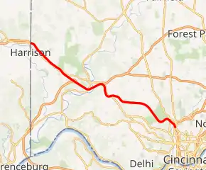
The Ohio portion of Interstate 74 begins on the Indiana border near Harrison, Ohio and travels due east. Shortly into Ohio, the interstate intersects with Interstate 275 and overlaps with I-275 for approximately 4 miles. The interstate continues for approximately 10 more miles before reaching its eastern terminus at the intersection with Interstate 75.
Future
Long term plans call for Interstate 74 to be continued through Ohio and into West Virginia, concurrent with Interstate 73; with both of these roads continuing through Virginia and North Carolina to end in Myrtle Beach, South Carolina. Due to funding concerns, there are no concrete plans for this to occur.
However, several plans are in the running for the extension through the Cincinnati metro area. They include: 1. Run along Interstates 75 and 275, then onto Ohio 32; 2. Interstate 75 between I-74/75 interchange and I-75/Ohio 562 interchange, then Ohio 562, Interstate 71 between Ohio 562 and Red Bank corridor, down the Red Bank corridor, and along a new highway connector to Ohio 32; and 3. I-74/75 interchange to I-75/Ohio 562 interchange, then Ohio 562, then along Interstates 71 and 275 before connecting to Ohio 32.
The second route was eliminated due to opposition regarding part of its completion: a $366.2 million highway that would need to be constructed. Total costs would have been $809.1 million. Improvements to existing roads have been proposed instead.
The Norwood Lateral would need to be reconstructed in order to become part of Interstate 74. It needs the following: a third travel lane in each direction (two each currently), overpasses that might need to be replaced, upgraded ramp extensions at interchanges and widened shoulders.
Exit list
The entire route is in Hamilton County.
| Location | mi[2] | km | Exit | Destinations | Notes | |
|---|---|---|---|---|---|---|
| Harrison | 0.00 | 0.00 | Indiana state line | |||
| 1.60 | 2.57 | 1 | New Haven Road – Harrison | |||
| 3.58 | 5.76 | 3 | Dry Fork Road | |||
| Whitewater Township | 5.85 | 9.41 | 5 | West end of I-275 overlap; I-275 exit 25 | ||
| 7.76 | 12.49 | 7 | ||||
| Colerain Township | 9.33 | 15.02 | 9 | East end of I-275 overlap; I-275 exit 28 | ||
| Green Township | 11.16 | 17.96 | 11 | Rybolt Road, Harrison Pike | ||
| 14.66 | 23.59 | 14 | North Bend Road – Cheviot | |||
| Cincinnati | 17.44 | 28.07 | 17 | Montana Avenue | Westbound exit and eastbound entrance | |
| 18.40– 18.52 | 29.61– 29.81 | 18 | No direct access from I-74 west to Beekman Street south or from Beekman Street north to I-74 east, however, a legal U-turn allows both of these accesses to be achieved. | |||
| 19.08 | 30.71 | 19 | Elmore Street, Spring Grove Avenue | Former westbound exit and eastbound entrance to I-75 south; closed 2013 | ||
| 19.47 | 31.33 | I-75 exit 4; US 27 and US 52 overlaps end east; Unsigned US 27 | ||||
| 19.47 | 31.33 | 20 | Former eastern end of US 27 overlap; closed prior to 2015 | |||
1.000 mi = 1.609 km; 1.000 km = 0.621 mi
| ||||||
References
- Federal Highway Administration (2002-10-31). "FHWA Route Log and Finder List: Table 1". Retrieved 2009-02-24.
- "Hamilton County Roadway Description Inventory Report — DESTAPE" (PDF). Ohio Department of Transportation. June 24, 2015: 31–33. Retrieved September 12, 2015. Cite journal requires
|journal=(help)
| Previous state: Indiana |
Ohio | Next state: West Virginia |