Iowa Highway 44
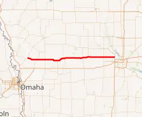
Iowa Highway 44 (Iowa 44) is an east–west highway in the central and west-central portions of the state. It runs parallel to Interstate 80, which runs 10 miles (16 km) to the north for most of its route. Iowa 44 begins at its junction with U.S. Highway 30 four miles (6 km) northeast of Logan. It ends at an interchange with the Iowa Highway 141 freeway at Grimes. Iowa 44 was created in 1969 when Iowa Highway 64 was shortened to its current route in eastern Iowa. Most of the route is a part of the Western Skies Scenic Byway.
| ||||
|---|---|---|---|---|
Iowa 44 highlighted in red | ||||
| Route information | ||||
| Maintained by Iowa DOT | ||||
| Length | 104.524 mi[1] (168.215 km) | |||
| Existed | January 1, 1969[2]–present | |||
| Tourist routes | Western Skies Scenic Byway | |||
| Major junctions | ||||
| West end | ||||
| ||||
| East end | ||||
| Location | ||||
| Counties | ||||
| Highway system | ||||
| ||||

Route description
Iowa Highway 44 begins between Logan and Woodbine on U.S. Highway 30. It goes east to Portsmouth, where it intersects Iowa Highway 191, then continues east to Harlan, where it intersects U.S. Highway 59. It continues east from Harlan and intersects Iowa Highway 173 at Kimballton and U.S. Highway 71 at Hamlin. It then continues to Guthrie Center, where it intersects Iowa Highway 25 and Panora, where it intersects Iowa Highway 4. It then intersects U.S. Highway 169 three miles (5 km) before entering Dallas Center and ends at a freeway interchange with Iowa Highway 141 in Grimes in the Des Moines metropolitan area.
History
Iowa 44 was created on January 1, 1969, when the Iowa State Highway Commission reorganized the state's primary highway system. Iowa 44 was one of 26 state highways to receive a new route number.[3] Prior to 1969, what is now Iowa 44 was part of two highways, Iowa 64 and Iowa 39.[4] Since its designation, the route has undergone few changes.
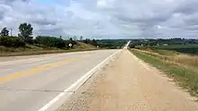
The westernmost 74 miles (119 km) of Iowa 44 are part of the state's Western Skies Scenic Byway.[5]
Major intersections
| County | Location | mi[1] | km | Destinations | Notes |
|---|---|---|---|---|---|
| Harrison | Jefferson Township | 0.000 | 0.000 | ||
| Shelby | Portsmouth | 11.547 | 18.583 | ||
| Harlan | 20.873 | 33.592 | |||
| Audubon | Kimballton | 35.337 | 56.869 | ||
| Hamlin | 45.225 | 72.783 | |||
| Guthrie | Guthrie Center | 66.448 | 106.938 | ||
| Panora | 74.023 | 119.128 | |||
| Dallas | Dallas Center | 91.586 | 147.393 | ||
| Polk | Grimes | 104.524 | 168.215 | ||
| 1.000 mi = 1.609 km; 1.000 km = 0.621 mi | |||||
References
- 2009 Volume of Traffic on the Primary Road System of Iowa (PDF) (Report). Iowa Department of Transportation. January 1, 2009. Retrieved January 20, 2011.
- Iowa State Highway Map (PDF) (Map). Iowa Department of Transportation. 1969. Retrieved February 12, 2011.
- "New Iowa Map Goes On Sale". Telegraph-Herald. Dubuque, Iowa. January 14, 1969. p. 7. Retrieved February 12, 2011.
- Iowa State Highway Map (PDF) (Map). Iowa State Highway Commission. 1968. Retrieved February 12, 2011.
- Iowa Department of Transportation. "Western Skies Scenic Byway" (PDF). Retrieved July 17, 2011.