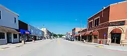
Logan, Iowa
Logan is a city and county seat of Harrison County, Iowa, United States, along the Boyer River. The population was 1,534 at the 2010 census.
Logan, Iowa | |
|---|---|
 | |
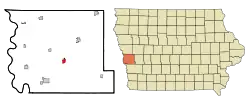 Location of Logan within Harrison County and Iowa | |
| Coordinates: 41°38′41″N 95°47′24″W | |
| Country | United States |
| State | Iowa |
| County | Harrison |
| Incorporated | April 22, 1876 [1] |
| Government | |
| • Mayor | Clint Mcdonald [2] |
| Area | |
| • Total | 1.00 sq mi (2.60 km2) |
| • Land | 1.00 sq mi (2.60 km2) |
| • Water | 0.00 sq mi (0.00 km2) |
| Elevation | 1,086 ft (331 m) |
| Population | |
| • Total | 1,534 |
| • Estimate (2019)[5] | 1,418 |
| • Density | 1,413.76/sq mi (545.72/km2) |
| Time zone | UTC-6 (CST) |
| • Summer (DST) | UTC-5 (CDT) |
| ZIP codes | 51546, 51550 |
| Area code | 712 |
| FIPS code | 19-46155 |
| GNIS feature ID | 0458561 |
| Website | www |
History
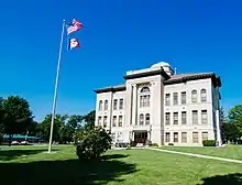
Logan was platted in 1867 when Chicago and North Western Railway was extended to that point.[6] It was named for John A. Logan, a Union Army general.[7]
Geography
Logan's longitude and latitude coordinates in decimal form are 41.644614, -95.789931.[8] According to the United States Census Bureau, the city has a total area of 1.00 square mile (2.59 km2), all of it land.[9]
Demographics
| Year | Pop. | ±% |
|---|---|---|
| 1880 | 644 | — |
| 1890 | 827 | +28.4% |
| 1900 | 1,377 | +66.5% |
| 1910 | 1,453 | +5.5% |
| 1920 | 1,637 | +12.7% |
| 1930 | 1,654 | +1.0% |
| 1940 | 1,700 | +2.8% |
| 1950 | 1,550 | −8.8% |
| 1960 | 1,605 | +3.5% |
| 1970 | 1,526 | −4.9% |
| 1980 | 1,540 | +0.9% |
| 1990 | 1,401 | −9.0% |
| 2000 | 1,545 | +10.3% |
| 2010 | 1,534 | −0.7% |
| 2019 | 1,418 | −7.6% |
| Source:"U.S. Census website". United States Census Bureau. Retrieved 2020-03-29. and Iowa Data Center Source: | ||
2010 census
As of the census[4] of 2010, there were 1,534 people, 595 households, and 397 families living in the city. The population density was 1,534.0 inhabitants per square mile (592.3/km2). There were 649 housing units at an average density of 649.0 per square mile (250.6/km2). The racial makeup of the city was 98.6% White, 0.1% African American, 0.1% Native American, 0.4% Asian, and 0.8% from two or more races. Hispanic or Latino of any race were 0.8% of the population.
There were 595 households, of which 35.0% had children under the age of 18 living with them, 54.1% were married couples living together, 9.1% had a female householder with no husband present, 3.5% had a male householder with no wife present, and 33.3% were non-families. 27.2% of all households were made up of individuals, and 14.1% had someone living alone who was 65 years of age or older. The average household size was 2.49 and the average family size was 3.07.
The median age in the city was 38.5 years. 26.9% of residents were under the age of 18; 6.1% were between the ages of 18 and 24; 25.5% were from 25 to 44; 24.9% were from 45 to 64; and 16.7% were 65 years of age or older. The gender makeup of the city was 48.7% male and 51.3% female.
2000 census
As of the census[11] of 2000, there were 1,545 people, 608 households, and 395 families living in the city. The population density was 1,522.8 people per square mile (590.6/km2). There were 660 housing units at an average density of 650.5 per square mile (252.3/km2). The racial makeup of the city was 99.29% White, 0.13% African American, 0.13% Native American, 0.13% Asian, 0.13% from other races, and 0.19% from two or more races. Hispanic or Latino of any race were 0.65% of the population.
There were 608 households, out of which 32.4% had children under the age of 18 living with them, 53.8% were married couples living together, 8.6% had a female householder with no husband present, and 35.0% were non-families. 32.2% of all households were made up of individuals, and 18.1% had someone living alone who was 65 years of age or older. The average household size was 2.43 and the average family size was 3.09.
Age spread: 27.1% under the age of 18, 6.1% from 18 to 24, 27.5% from 25 to 44, 18.2% from 45 to 64, and 21.1% who were 65 years of age or older. The median age was 38 years. For every 100 females, there were 90.0 males. For every 100 females age 18 and over, there were 79.9 males.
The median income for a household in the city was $35,455, and the median income for a family was $44,375. Males had a median income of $30,347 versus $20,625 for females. The per capita income for the city was $18,709. About 5.6% of families and 9.5% of the population were below the poverty line, including 10.0% of those under age 18 and 11.6% of those age 65 or over.
Education
Logan-Magnolia Community School District operates local public schools.[12]
See also
References
- "Logan, Iowa". City-Data. Retrieved May 14, 2011.
- "Harrison County Development Corporation". Harrison County, IA. Archived from the original on September 6, 2008. Retrieved 2008-12-13.
- "2019 U.S. Gazetteer Files". United States Census Bureau. Retrieved July 17, 2020.
- "U.S. Census website". United States Census Bureau. Retrieved 2012-05-11.
- "Population and Housing Unit Estimates". United States Census Bureau. May 24, 2020. Retrieved May 27, 2020.
- History of Western Iowa, Its Settlement and Growth. Western Publishing Company. 1882. pp. 315.
- Chicago and North Western Railway Company (1908). A History of the Origin of the Place Names Connected with the Chicago & North Western and Chicago, St. Paul, Minneapolis & Omaha Railways. p. 95.
- "US Gazetteer files: 2010, 2000, and 1990". United States Census Bureau. 2011-02-12. Retrieved 2011-04-23.
- "US Gazetteer files 2010". United States Census Bureau. Archived from the original on 2012-07-02. Retrieved 2012-05-11.
- "Census of Population and Housing". Census.gov. Retrieved June 4, 2015.
- "U.S. Census website". United States Census Bureau. Retrieved 2008-01-31.
- "LOGAN-MAGNOLIA" (PDF). Iowa Department of Education. Retrieved 2020-08-31.
External links
| Wikimedia Commons has media related to Logan, Iowa. |
- City of Logan
- Logan-Magnolia Community Schools
- City-Data Comprehensive Statistical Data and more about Logan
Municipalities and communities of Harrison County, Iowa, United States | ||
|---|---|---|
| Cities | Map of Iowa highlighting Harrison County | |
| Townships | ||
| CDPs | ||
| Other unincorporated communities | ||
| Footnotes | ‡This populated place also has portions in an adjacent county or counties | |
| ||
Metropolitan area of Omaha–Council Bluffs | ||||||
|---|---|---|---|---|---|---|
| Primary cities |
|  | ||||
| Cities over 10,000 (per 2010 Census) |
| |||||
| Cities of 5,000 to 10,000 (per 2010 Census) |
| |||||
| Cities of 1,000 to 5,000 (per 2010 Census) |
| |||||
| Census-designated places |
| |||||
| Cities and villages of fewer than 1,000 (per 2010 Census) |
| |||||
| Counties |
| |||||
| Authority control |
|---|