Isabelle Glacier
Isabelle Glacier is an alpine glacier located .25 mi (0.40 km) southwest of Shoshoni Peak, in Roosevelt National Forest in the US state of Colorado.[2] The glacier is immediately east of the Continental Divide on the opposite side of the divide from Fair Glacier. Isabelle Glacier is the source of the South Saint Vrain Creek and can be reach by trail and is a 8.4 mi (13.5 km) round-trip hike from the trailhead.[3]
| Isabelle Glacier | |
|---|---|
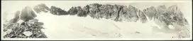 Isabelle Glacier as photographed in the 1920s | |
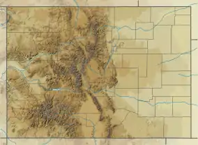 Isabelle Glacier Location in Colorado | |
| Type | Mountain glacier |
| Location | Boulder County, Colorado, United States |
| Coordinates | 40°03′48″N 105°38′42″W[1] |
| Length | .15 mi (0.24 km) and .30 mi (0.48 km) wide |
| Terminus | Talus/proglacial lake |
| Status | Retreating |
References
- "Isabelle Glacier". Geographic Names Information System. United States Geological Survey. Retrieved August 18, 2012.
- Monarch Lake, CO (Map). TopoQwest (United States Geological Survey Maps). Retrieved August 18, 2012.
- "Isabelle Glacier Trail". Summitpost. Retrieved August 18, 2012.
This article is issued from Wikipedia. The text is licensed under Creative Commons - Attribution - Sharealike. Additional terms may apply for the media files.