Ithriya
Ithriya (Arabic: أثريا), Roman "Seriana". is a Syrian village located in Al-Saan Nahiyah in Salamiyah District, Hama. According to the Syria Central Bureau of Statistics (CBS), Ithriya had a population of 2118 in the 2004 census.[1]
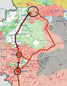
Situation of land access in Northern Central Syria during Syrian Civil War in early 2017.
Ithriya
أثريا | |
|---|---|
Village | |
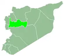
 Ithriya Location in Syria | |
| Coordinates: 35.3692°N 37.7859°E | |
| Country | |
| Governorate | Hama |
| District | Salamiyah District |
| Subdistrict | Al-Saan Nahiyah |
| Population (2004) | |
| • Total | 2,118 |
| Time zone | UTC+2 (EET) |
| • Summer (DST) | UTC+3 (EEST) |
| City Qrya Pcode | C3273 |
History
In Roman times in Near Antiquity, Seriana housed a temple, known as the Church of Seriana.
During the Syrian Civil War, Ithriyah became a strategically important point. It lays on the last highway under government control connecting the city of Aleppo to Khanasir and the Salamiyah region. In the Ithriyah-Raqqa offensive (February–March 2016) and Ithriyah-Raqqa offensive (June 2016), the town was used as a launching point for offensives against IS.
References
- "General Census of Population 2004". Retrieved 2014-07-10.
This article is issued from Wikipedia. The text is licensed under Creative Commons - Attribution - Sharealike. Additional terms may apply for the media files.
