Jablana, Zagorje ob Savi
Jablana (pronounced [ˈjaːblana]) is a settlement in the hills west of Zagorje ob Savi in central Slovenia. The area is part of the traditional region of Upper Carniola. It is now included with the rest of the Municipality of Zagorje ob Savi in the Central Sava Statistical Region.[2]
Jablana | |
|---|---|
 | |
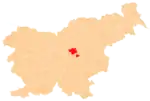
 Jablana Location in Slovenia | |
| Coordinates: 46°7′16.91″N 14°57′1.12″E | |
| Country | |
| Traditional region | Upper Carniola |
| Statistical region | Central Sava |
| Municipality | Zagorje ob Savi |
| Area | |
| • Total | 2.48 km2 (0.96 sq mi) |
| Elevation | 770.7 m (2,528.5 ft) |
| Population (2002) | |
| • Total | 90 |
| [1] | |
Geography
Jablana is a clustered village on a slope on the east side of Jablana Peak (Slovene: Jablanski vrh; 902 meters or 2,959 feet).[3] It includes the hamlets of Vodice to the northeast[3] and Mala Peč to the east. Kal was formerly a hamlet of Jablana, but it became a separate village in 2000.[4] The soil is sandy.[3]
Church
The local church is dedicated to the Holy Cross and belongs to the Parish of Šentlambert. It dates to the second half of the 16th century.[5]
References
- Statistical Office of the Republic of Slovenia
- Zagorje ob Savi municipal site Archived 2012-03-06 at the Wayback Machine
- Savnik, Roman (1976). Krajevni leksikon Slovenije, vol. 3. Ljubljana: Državna založba Slovenije. p. 453.
- "Naselje Kal". tatistični urad Republike Slovenije. Retrieved April 19, 2018.
- Slovenian Ministry of Culture register of national heritage reference number ešd 2466
External links
- Jablana on Geopedia
 Media related to Jablana, Zagorje ob Savi at Wikimedia Commons
This article is issued from Wikipedia. The text is licensed under Creative Commons - Attribution - Sharealike. Additional terms may apply for the media files.