Jacó, Costa Rica
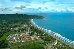
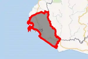
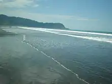
Jacó is a district of the Garabito canton, in the Puntarenas province of Costa Rica.[1][2] Jacó has a black sand beach that is 4 km (2.5 mi) long and is popular among surfers.[3]
Jacó | |
|---|---|
 Jacó Beach | |
Jacó district | |
 Jacó Jacó district location in Costa Rica | |
| Coordinates: 9.6200496°N 84.6044399°W | |
| Country | |
| Province | Puntarenas |
| Canton | Garabito |
| Creation | 16 September 1965 |
| Area | |
| • Total | 141.11 km2 (54.48 sq mi) |
| Elevation | 7 m (23 ft) |
| Population (2011) | |
| • Total | 11,685 |
| • Density | 83/km2 (210/sq mi) |
| Time zone | UTC−06:00 |
| Postal code | 61101 |
History
Jacó was created on 16 September 1965. Segregated from Puntarenas.[2]
Geography
Jacó has an area of 141.11 km²[4] and an elevation of 7 metres.[1]
Jacó lies between several mountains, and is neighbored by the beaches of Herradura Bay to the North, and Playa Hermosa to the South (not to be confused with another beach by the same name, but located in Guanacaste). About 35 kilometers north of Jacó, lies the Carara National Park, recognized for its exuberant wildlife and dense rain forest. Carara is home to one of the largest remaining populations of wild scarlet macaws in the country. The ecotourism park Rainforest Adventures, NatGeo´s top ten of adventure trips,[5] is just 5 minutes from the beach and it features an aerial tram through the transitional forest. The Manuel Antonio National Park is located 75 kilometres south of Jacó.
Jacó lies about 100 kilometers (a little less than two hours via Route 34) from the capital San José and an hour and a half from Costa Rica's primary international airport, Juan Santamaría International, accessed via Route 27 and Route 34.
Climate
As Jacó lies on the seashore, climate is normally humid, with relative humidity around 80%, reaching 90% in June. Temperature is 24–32 °C (75–90 °F) during the day and 24–26 °C (75–79 °F) at night. During the dry season, away from the water, the temperature may consistently reach 35 °C (95 °F) or above.
Jacó lies in a tropical climate zone mainly defined by distinct dry and wet seasons. Generally speaking, August through early December are wet, and late December through early April are dry; the remaining months have irregular rainy spells.
Demographics
| Historical population | |||
|---|---|---|---|
| Census | Pop. | %± | |
| 1973 | 2,959 | — | |
| 1984 | 3,144 | 6.3% | |
| 2000 | 6,371 | 102.6% | |
| 2011 | 11,685 | 83.4% | |
|
Instituto Nacional de Estadística y Censos[6] |
|||
For the 2011 census, Jacó had a population of 11,685 inhabitants. [8]
Transportation
Economy
Surfing
The beach in Jacó hosts several surfing schools and various shops that sell and rent equipment for surfing. Jacó is also near beaches for more professional surfers, such as Hermosa Beach, which is just five minutes away, with pipes and beach break for experienced surfers only.[9]
Things to do
Jacó is not only known for its beaches and nightlife, but is near several national parks. Manuel Antonio National Park is only about an hour to the south. There are several excursions available in Jacó, such as ATV and horseback riding tours, snorkeling cruise to Tortuga Island, hiking, and ziplining.
References
- "Declara oficial para efectos administrativos, la aprobación de la División Territorial Administrativa de la República N°41548-MGP". Sistema Costarricense de Información Jurídica (in Spanish). 19 March 2019. Retrieved 26 September 2020.
- División Territorial Administrativa de la República de Costa Rica (PDF) (in Spanish). Editorial Digital de la Imprenta Nacional. 8 March 2017. ISBN 978-9977-58-477-5.
- Stater, Adam. "Jacó". Archived from the original on 2013-06-16.
- "Área en kilómetros cuadrados, según provincia, cantón y distrito administrativo". Instituto Nacional de Estadística y Censos (in Spanish). Retrieved 26 September 2020.
- http://travel.nationalgeographic.com/travel/photos-top-10-adventure-trips/#/costa-rica-adventure-zip_86051_600x450.jpg
- "Instituto Nacional de Estadística y Censos" (in Spanish).
- "Sistema de Consulta de a Bases de Datos Estadísticas". Centro Centroamericano de Población (in Spanish).
- "Censo. 2011. Población total por zona y sexo, según provincia, cantón y distrito". Instituto Nacional de Estadística y Censos (in Spanish). Retrieved 26 September 2020.
- "8 best surfing beaches in costa rica".
External links
 Jacó travel guide from Wikivoyage
- Playa Hermosa (Garabito) travel guide from Wikivoyage