Corredores (canton)
Corredores is a canton in the Puntarenas province of Costa Rica.[2][3] The head city is Ciudad Neily in Corredor district.
Corredores | |
|---|---|
 Seal | |
Corredores canton | |
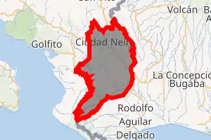
 Corredores Corredores canton location in Costa Rica | |
| Coordinates: 8.5380105°N 82.9457347°W | |
| Country | |
| Province | Puntarenas |
| Creation | 19 October 1973[1] |
| Head city | Ciudad Neily, Corredor |
| Districts | |
| Government | |
| • Type | Municipality |
| • Body | Municipalidad de Corredores |
| Area | |
| • Total | 620.6 km2 (239.6 sq mi) |
| Elevation | 58 m (190 ft) |
| Population (2011) | |
| • Total | 41,831 |
| • Density | 67/km2 (170/sq mi) |
| Time zone | UTC−06:00 |
| Canton code | 610 |
| Website | www |
History
Corredores was created on 19 October 1973 by decree 5373.[1]
Geography
Corredores has an area of 620.6 km²[4] and a mean elevation of 58 metres.[2]
The lowland canton shares its eastern border with Panama. The Conte River marks the western limit. The northern boundary runs through the Zapote Ridge, one of the coastal mountain ranges.
Districts
The canton of Corredores is subdivided into the following districts:
Demographics
| Historical population | |||
|---|---|---|---|
| Census | Pop. | %± | |
| 1984 | 28,366 | — | |
| 2000 | 37,274 | 31.4% | |
| 2011 | 41,831 | 12.2% | |
|
Instituto Nacional de Estadística y Censos[5] |
|||
For the 2011 census, Corredores had a population of 41,831 inhabitants. [7]
Transportation
Road transportation
The canton is covered by the following road routes:
References
- Hernández, Hermógenes (1985). Costa Rica: evolución territorial y principales censos de población 1502 - 1984 (in Spanish) (1 ed.). San José: Editorial Universidad Estatal a Distancia. pp. 164–173. ISBN 9977-64-243-5. Retrieved 5 October 2020.
- "Declara oficial para efectos administrativos, la aprobación de la División Territorial Administrativa de la República N°41548-MGP". Sistema Costarricense de Información Jurídica (in Spanish). 19 March 2019. Retrieved 26 September 2020.
- División Territorial Administrativa de la República de Costa Rica (PDF) (in Spanish). Editorial Digital de la Imprenta Nacional. 8 March 2017. ISBN 978-9977-58-477-5.
- "Área en kilómetros cuadrados, según provincia, cantón y distrito administrativo". Instituto Nacional de Estadística y Censos (in Spanish). Retrieved 26 September 2020.
- "Instituto Nacional de Estadística y Censos" (in Spanish).
- "Sistema de Consulta de a Bases de Datos Estadísticas". Centro Centroamericano de Población (in Spanish).
- "Censo. 2011. Población total por zona y sexo, según provincia, cantón y distrito". Instituto Nacional de Estadística y Censos (in Spanish). Retrieved 26 September 2020.
This article is issued from Wikipedia. The text is licensed under Creative Commons - Attribution - Sharealike. Additional terms may apply for the media files.